| NOTE:
This is an old catalogue and many of these items are probably sold. Please contact as I may have similar items in stock. It shows the range of items I specialise in BUYING and SELLING. |
Bristol
RARE HAND-COLOURED PLAN Ashmead (G.C) ASHMEAD'S MAP OF THE CITY AND BOROUGH OF BRISTOL, Reduced from the Original Survey and corrected to 1871. Fine engraved plan, dissected and mounted on linen, folding into original 8vo, unlettered cloth boards, overall size of map approx. 38" x 34". Scale approx. 1" to 1 furlong. With Reference tables of Public Buildings, Schools, Almshouses, Dissenting Chapels, Principal inns and Hotels etc. With the wards hand-coloured, and outlined in a deeper shade. Published by G.C. Ashmead & Son, 11 Small Street, Bristol: March, 1871. £550.00 -- See Illustration
¶ Ashmead issued his first plan of Bristol in 1828. This was largely based on the work of Joseph Plumley who died after only issuing the prospectus for his map. This first Ashmead map measured 75" x 58" with a scale of 200 feet = 1 inch. Ashmead went on to issue smaller, reduced scale, plans of Bristol in 1833, 1846, 1855, 1871 and 1882. This edition extends from Windmill Hill to Cold Harbour Farm in the north, from the Black Swan on Stapleton Road to Nightingale Valley in the West.
Chilcott (J) A NEW PLAN OF BRISTOL, CLIFTON and the Hot-Wells. Engraved plan size 9" x 11", with Key to References, listing 150 churches, public buildings, schools, etc. Dissected and mounted on linen, folding into cloth boards, 5" x 4", gilt titled. Coat of arms, scale bar, compass rose. Engraved by S. Hall, Bloomsbury, c1840. £34.00
Kingsdown SKETCH PLAN of 'Revd. Mr Foot's Gout. Top Part of St. Michael's Hill. May 1772.' Manuscript sketch plan, with measurements and crude compass rose, size 15" x 6", folds, showing road from 'Road to or from Gallows' at top to 'Mr Tendals Field' at the bottom, showing 'Pavement' and 'Main House', 'Bare Premises', 'Bare Stables', 'dung Hole' 'Pool 10ft by 12ft.''Gout covered to Pool', 'Willett's Garden', 'Holmses Garden'. The various features are described in more detail on verso with key letters, e.g. 'F. A kind of Reservoer or Pool into whitch the Gout empties itself. From this Pool to the ditch in Mr Tendals field is a open gout with only a small Canall Cutt in the Suface of the Garden'. 1772. £40.00 -- See Illustration
Lander's ELECTORAL DISTRICT MAP OF THE CITY AND COUNTY OF BRISTOL. This Map, (Comprising a Circuit of Nine Miles from the Guildhall,) Includes the Qualifying Residences of the Constituences of the City of Bristol, Both Parliamentary and Municipal. Accurately Copied from the Ordnance Survey with Additions & Corrections to the Year 1850. Hand coloured folding map, folding into original cloth boards, gilt title on top board, label inside front board with engraving of the Guildhall. Engraved surface of map approx. 19" x 19", attractive border. Bristol: 1850. £130.00
Lavars (J) LAVARS'S NEW MAP OF BRISTOL AND CLIFTON Lithographed and Published at his Offices, 18, Bridge Street Bristol. Map size 11" x 17", plus margins, key to buildings down left and right margins. With 12pp street index. Folding into 12mo cloth boards with attractive yellow printed label with coat of arms, etc. Lavars advert. with picture of lithographic roller inside front board. Two or three tiny splits where folds meet. Lavars, Bristol. 1870's. £50.00
A further selection of BRISTOL Items on Main Site
Back to the Top
Cornwall
Bodmin Road to Bodmin Railway GREAT WESTERN RAILWAY. CORNWALL RAILWAY. BODMIN BRANCH 2 CHAIN SURVEY 1904. M 274 to M 280. Containing sheets Nos. 1-2 inclusive and with 2 sheets not numbered. 4 hand-coloured lithograph printed sheets, each sheet mounted on linen with a single vertical fold, overall size approx. 25" x 40", recently bound in half cloth paper boards, paper label on top board. Size of the volume approx. 25" x 23". There are two plans of the railway line, each showing 1 mile of track, on each Sheet. Scale 2 chains to 1". Compass rose and scale bar on each sheet. Verso of maps very slightly dusty, otherwise a clean set, small piece missing from foot of last leaf, not affecting the lithographed surface. London: Thos. Kell and Son, Lithographers. 1904. £180.00 -- See Illustration
¶ The plans show the route of the railway from Bodmin Road Station to Bodmin Station, and include fine detailed plans of each station, and a small separate plan of Boscarne Junction. They include the adjacent buildings, houses, signal boxes, goods sheds, cranes, taps, troughs, smithies, oil tanks, etc. The plans also show viaducts, bridges and their span, tunnels, parish boundaries, woodland, wells, quarries etc. The names of the landowners adjacent are shown with details of leases or conveyances. There are occasional later details of land transactions neatly written in red ink, up to the 1950's. The distance from Paddington is shown at quarter of a mile intervals.
Christopher Consols SECTION ON THE ENGINE LODE Plan, in ink, with a little shading, size 30" x 45", linen backed, showing the engine house and adjacent buildings in elevation, with the engine shaft and other shafts. Some light shading, some rough figures in pencil, cross-course marked. No scale bar or other reference. Rusty stab holes along top edge where once attached to roller, edges rather ragged, dusty overall. c1840. £80.00
Dean (Charles), Survr., Cathedral Yard, Exeter MANOR OF DEANSTURSDON IN THE PARISH OF MORWENSTOW CORNWALL 1823 Manuscript map in ink and full wash colour, on Whatman paper, size 25" x 32", folded, scale 1" = 5 chains. Scale bar, compass arrow, title in variety of lettering styles, the word 'Devon' crossed out and 'Cornwall' added. Comprises five areas of land: Dassell; Stursdon; Lapthorne; Centre; and two 'Bartons', one near the church and another adjoining the road from Woolley to Cross Town. Indicates buildings (coloured red), including Morwenstow Church, fields, hedges, roads and yards (coloured buff), woodland, adjoining owners. Fields shaded green, with a darker greyish colour shewing higher land. Fields numbered 1-25, with a later Reference Key added in pencil to all the numbers. The paper inside the 'O' in 'Cornwall' of the title has formed a small hole, 10" tear from left hand margin re-inforced on verso with paper, short splits at folds repaired on verso with archival tape. Some grubby marks at edges in a few places, old ink blot in one field, a few ragged edge tears at left hand side. 1823. £200.00 -- See Illustration
Lostwithiel to Burngullow Station Railway GREAT WESTERN RAILWAY. CORNWALL RAILWAY 2 CHAIN SURVEY 1908. M 277 to M 295. Volume 137. Containing sheet Nos. 17-24 inclusive. 8 hand-coloured lithograph printed sheets, each sheet mounted on linen with a single vertical fold, overall size approx. 27" x 41", recently bound in half roan, paper boards, with the gilt title from the original wraps laid down as a label on the front board. Size of the volume approx. 27" x 23". There are two plans of the railway line, each showing 1 mile of track on each Sheet. Scale 2 chains to 1". Compass rose and scale bar on each sheet. Verso of maps very slightly dusty, light waterstain to the top of four plans, not affecting the lithographed surface, otherwise a clean set. London: Waterlow and Sons Lithographers. 1908. £240.00 -- See Illustration
¶ The plans show the route of the railway from just before Lostwithiel Station to Burngullow Station and on to the Fal and Coombe Viaducts, and include fine detailed plans of Lostwithiel, Par, St. Austell, and Burngullow stations, including the adjacent buildings, houses, signal boxes, goods sheds, cattle pens, cranes, taps, troughs, smithies, oil tanks, etc. The plans also show viaducts, bridges and their span, tunnels, parish boundaries, woodland, wells, mine shafts, quarries etc. The names of the landowners adjacent are shown with details of leases or conveyances. There are occasional later details of land transactions neatly written in red ink, up to the 1950's. The distance from Paddington is shown at quarter of a mile intervals.
Lostwithiel to Fowey to Bugle Mineral Railways GREAT WESTERN RAILWAY. CORNWALL MINERAL RAILWAYS 2 CHAIN SURVEY. 1909-12. Containing sheet 10 hand-coloured lithograph printed sheets, each sheet mounted on linen, overall size approx. 25" x 43", lacks covers disbound. There are two plans of the railway line, each showing 1 mile of track on each Sheet. Scale 2 chains to 1". Compass rose and scale bar on each sheet. Verso of maps very slightly dusty, otherwise a clean set, fore-edges slightly ragged, some short tears, corners curled and paper chipped. London: Robert J. Cook and Hammond, Lithographers. 1910-12. £260.00 -- See Illustration
¶ The plans show the route of the railway from Lostithiel to Bugle, with fine detailed plans of Fowey, St. Blazey, Par, Luxulyan and Bugle stations and various sidings including:- Wheal Virgin Clay Works, East Goonbarrow Clay Works, Ponts Mill Clay Works. The plans include the adjacent buildings, houses, signal boxes, goods sheds, cattle pens, cranes, taps, troughs, smithies, oil tanks, etc. The plans also show viaducts, bridges and their span, tunnels, parish boundaries, woodland, wells, clay works, quarries etc. The names of the landowners adjacent are shown with details of leases or conveyances. There are occasional later details of land transactions neatly written in red ink, up to the 1950's. The distance from Paddington is shown at quarter of a mile intervals.
Martyn (Thos.) A NEW AND ACCURATE MAP OF THE COUNTY OF CORNWALL, From an Actual Survey Made by Thos. Martyn. Folding engraved map, scale half an inch to 1 mile, hand-coloured in outline, dissected and mounted on linen, marbled endpapers, rubbed, folding to 8vo. Engraved area approx. 28" x 40", plus margins. Scale approx. half inch to one mile. Hand-coloured in outline. With inset of Isles of Scilly, decorative title, compass rose, scale bar, numerous sailing ships, decorative oval cartouche with Explanation, large ornamental cartouche with dedication to Robert Hoblyn of Nanswhyden, showing seated classical figure with baskets of pilchards, nets, book open at illustration of St. Michaels Mount. Down the right hand side are three insets each approx. 5" x 3" illustrating incribed stones. Small area of rubbing in blank sea area at bottom, about a quarter of an inch wide and six inches long, some browning of linen between some sections, title written in crayon on back of map. Second Edition, Corrected, Printed for James Wyld, Geographer to the Queen, Charing Cross East, 1842. £580.00 -- See Illustration
¶ This is a reprint of Faden's map of 1784. This edition is not in Quixley's 'Antique Maps of Cornwall and the Isles of Scilly', or Boase and Courteney's 'Bibliotheca Cornubiensis.'
Menheniot to Bodmin Road Railway GREAT WESTERN RAILWAY. CORNWALL RAILWAY 2 CHAIN SURVEY 1906-8. M 261 to M 277. Volume 136. Containing sheet Nos. 9-16 inclusive. 8 hand-coloured lithograph printed sheets, each sheet mounted on linen with a single vertical fold, overall size approx. 27" x 47", recently bound in half roan, paper boards, with the gilt title from the original wraps laid down as a label on the front board. Size of the volume approx. 27" x 23". There are two plans of the railway line, each showing 1 mile of track, on each Sheet. Scale 2 chains to 1". Compass rose and scale bar on each sheet. Verso of maps very slightly dusty, otherwise a clean set, title and scale bar slightly shaved on one sheet. London: Waterlow and Sons Lithographers. 1906-8. £250.00
¶ The plans show the route of the railway from just before Menheniot Station to just after Bodmin Road Station, and include fine detailed plans of Menheniot, Liskeard, Doublebois, and Bodmin Road stations, including the adjacent buildings, houses, signal boxes, goods sheds, cattle pens, cranes, taps, troughs, smithies, oil tanks, etc. The plans also show viaducts, bridges and their span, tunnels, parish boundaries, woodland, wells, mine shafts, quarries etc. The names of the landowners adjacent are shown with details of leases or conveyances. There are occasional later details of land transactions neatly written in red ink, up to the 1950's. The distance from Paddington is shown at quarter of a mile intervals.
Ordnance Survey THE THIRD PART OF THE GENERAL SURVEY OF ENGLAND AND WALES Containing Cornwall and a Portion of the adjoining County. Done by The Surveyor of His Majesty's ordnance under the Direction of Col. Mudge, of The Royal Artillery, F.R & A.S. Eight map sheets, bound in atlas folio, maps mounted on guards. Half calf, gilt, marbled boards, spine gilt, titled. Paper on boards, rubbed, with a small piece of paper missing at corner of back board, lacks 4" of calf at bottom of spine. part of spine lifting, with some splits in calf, corners slightly rubbed. Marbled endpapers, with key map inside front board. Comprises: Title sheet in decorative Gothic lettering, Sheets XXIV (5" repaired tear bottom left in sea area), XXVI, XXX, XXV, XXXIII, XXI, XXI, XXXII. A very light waterstain at the centre of the margin of the last two plates, sheets numbered 1-8 in small ink figures under Roman numerals. With inscription 'Cory Kingdon 1817' on flyleaf. Published 11th October 1809 and 5th Jany. 1813 by Lt. Col. Mudge, Tower. £650.00
¶ A fine set of early impressions, some corresponding to Margary State 2, some to State 3. Cory Kingdon was a doctor who lived in Poughill.
Porkellis United Mines, Wendron COUNTERPART SETT of Porkellis and part of Porkellis Moor, The Rt. Honorable Frances Baroness Basset to Messrs. Francis Ommanney, W.C. Winterbottom and Francis Bottrall. Distribution 1/18th in money. 3 vellum sheets, size 20" x 28", 3 wax seals. On verso of last sheet is a manuscript plan, coloured in outline, showing the village of Porkellis, with fields, buildings, stream, paths, Basset's Old Stamps, and Porkellis Wastrell. Boundaries of sett coloured, showing bound posts referred to in text, adjoining owners. Size of plan 26" x 13". 1851. £85.00
¶ The bounds are set out in detail. Stipulations included that a suitable steam engine be erected 'of power equal to one with a sixty inch cylinder.'
Redruth to Penzance Railway GREAT WESTERN RAILWAY. WEST CORNWALL RAILWAY 2 CHAIN SURVEY 1904. M 309 to M 326. Volume 140. Containing sheets Nos. 5-12 and 12a-13 inclusive. 10 hand-coloured lithographically printed sheets, each sheet mounted on linen with a single vertical fold, overall size approx. 24" x 42", recently bound in half roan, paper boards, with the gilt title from the original wraps laid down as a label on the front board. Size of the volume approx. 24" x 23". There are two plans of the railway line, each showing 1 mile of track, on each Sheet. Scale 2 chains to 1". Compass rose and scale bar on each sheet. Verso of maps very slightly dusty, small portion of top corner of last map missing, slightly affecting last 2 letters of 'Railway'. Few minor marks, scale bar to one sheet shaved. London: Martin, Hood and Larkin, Lithographers. 1904. £250.00
¶ The plans show the route of the railway from just before Redruth Station to Penzance Station, showing the shore line where the Railway is near the sea, and good details of the mines near the track, such as Straypark Mine at Camborne, where shafts, engine houses, mine refuse, overhead tramway, elevator, drying shed. With fine detailed plans of Redruth, Carn Brea, Camborne, Gwinear Road, Hayle, St. Erth, Marazion, and Penzance stations (including Albert Pier), including the adjacent buildings, houses, signal boxes, goods sheds, cattle pens, cranes, taps, troughs, smithies, oil tanks, etc. The plans also show viaducts, bridges and their span, tunnels, parish boundaries, woodland, wells, mine shafts, quarries etc. The names of the landowners adjacent are shown with details of leases or conveyances. There are occasional later details of land transactions neatly written in red ink, up to the 1950's. The distance from Paddington is shown at quarter of a mile intervals.
Roche to Newquay Mineral Railways GREAT WESTERN RAILWAY. CORNWALL MINERAL RAILWAYS 2 CHAIN SURVEY. 1910-12. Containing sheet 8 hand-coloured lithograph printed sheets, each sheet mounted on linen, overall size approx. 25" x 42", disbound, lacks covers. There are two plans of the railway line, each showing 1 mile of track on each Sheet. Scale 2 chains to 1". Compass rose and scale bar on each sheet. Verso of maps very slightly dusty, otherwise a clean set, fore-edges have a few, some short tears, corners curled and paper chipped, last leaf slightly dusty and some ink spots and splashes to lower edge. London: Martin, Hood and Larkin, Lithographers. 1910-12. £250.00
¶ The plans show the route of the railway from Roche to Newquay, with fine detailed plans of Roche, St Columb Road and Newquay stations, and Newquay Harbour. Shows adjacent buildings, houses, signal boxes, goods sheds, cattle pens, cranes, taps, troughs, smithies, oil tanks, etc. The plans also show viaducts, bridges and their span, tunnels, parish boundaries, woodland, wells, clay works, quarries etc. The names of the landowners adjacent are shown with details of leases or conveyances. There are occasional later details of land transactions neatly written in red ink, up to the 1950's. The distance from Paddington is shown at quarter of a mile intervals.
Rutger (I.H.), Surveyor A PLAN OF THE PARISH OF SENNEN in the County of Cornwall. 1839. Lithographed map, size 16" x 24", plus wide margins. Scale 10 chains to 1". Compass rose, scale bar. Shows buildings, each field numbered, rocky areas along shore indicated with hachures. Small repaired tear in margin, some slight creasing in margin at bottom right. Dean and Co. Lithr., Threadneedle St., 1839. £65.00 -- See Illustration
Sayer (Robert) PLAN OF THE ROAD AND HARBOUR OF FOWEY OR FOY. by Lieut. James Cook of the Royal Navy. in Cornwall. Fine copper plate engraving with wide margins, engraved surface approx. 25" x 19", scale 1" = 1 mile. Single fold. Printed for Robert Sayer, Map & Chartseller, No 53 Fleet Street, as the Act directs, Decmr. 1st 1786. £400.00
¶ Shows Mixto, Pendennick, Polruan, Menabilly, Coomb, good plan of Fowey with Place House and Tower shown in elevation. Shows features such as Hewitts Rope House, Windmill, Gun Batteries, St. Catherine's Castle, Poulrudman, etc. There are also 3 sections, including an attractive view size 1" x 9", of buildings in Fowey with surrounding hills.
A further selection of CORNISH Items on Main Site
Back to the Top
Cumberland
Kirkcambeck, nr. Brampton LANDOWNER'S RECORD BOOK WITH SKETCH PLANS recording leases and cultivation of the Farms of Ceracrop, High Green Hill, South Green Hill, North Green Hill, Patty's Hill, Dorry Field Farm. 4to notebook, stiff marbled wraps, comprises sketch plan of farm on right hand page, in ink showing named fields with acreage, wooded areas, buildings, roads, and on facing page 'A Register of the Annual Mode of Cultivation' for that farm, with columns for years 1808-1814 to the right of list of fields, below are details of the tenant and lease with details of lease such as acreage to be fallowed, repairs, hunting rights, etc. Only Cracrop farm has details in table filled in, for the first two years. Dorryfield farm does not have details of the lease. 1808. £120.00
Westward, near Wigton HAZELSPRING FARM The Property of The Right Honble. Lord Leconfield. 1864. Traced from unfinished Ordnance Plans of the Parish Westward. Lightly coloured manuscript plan in brownish tracing paper mounted on paper then on linen, size 28" x 30", folding into 8vo marbled wraps. Scale 25" to 1 mile. Shows buildings at Wallace Lane, Hazelspring, Hilltop, Studholme Rigg Wood, fields with acreage etc., river, streams, roads... together with... HILL TOP FARM The Property of the Right Honble Lord Leconfield. 1864. Similar plan, size 33 " x 55", folding into 8vo marbled wraps. The two plans fit together, with some overlap. The area of Hazelspring Farm is coloured pink and Hill Top Farm green. 2 items. Neat manuscript labels on wraps. Signed W.L.M. 12th March 1864. £80.00
A further selection of CUMBERLAND Items on Main Site
Back to the Top
Devon
Bere Ferrers PLAN OF RUMLEIGH BRICK FIELDS Showing Encroachments of Arsenical Works Built by Mr Thos. Westlake. 1885. Surveyed by R. Walters Land and Mining Surveyor. Tavistock August 1885. Manuscript plan in ink and full colour on cartridge paper, size 21" x 28", scale 1 chain to an inch. Border, decorative compass rose, scale bar. Shows River Tamar, sluice, furnaces, refining house, stack, smithy, flues, brick kiln, hedges, hedges destroyed, land occupied by Mr Martin. Reference table with coloured key showing leases, Arsenical Works encroaching on land leased for Brick Making, etc. Small piece torn away top right affecting corner of border. Folds, small repaired tear at one fold, two small splits in paper at another. Together with a small coloured basic sketch plan 'Land proposed to be leased as Rumleigh Brickfield 1879'. 1880. £95.00 -- See Illustration
Bere Ferrers QUANTITY OF LAND IN THE BARTON OF RUMLEIGH AND PHILLY in the Parish of Beer Ferrers in the County of Devon the Property of James Young Esq. Book of manuscript plans, 4to, full blindstamped reversed calf, decorative calligraphic title page, 6 pages of manuscript plans, on thick stiff paper, coloured in outline, with Schedules on facing page written in red and black, in tabular form, giving letter and number on plan, name of field, wood etc., acreage. Comprises full page 'Plan of the Barton of Rumleigh' showing River Tamar, house and surrounding estate; and the following small plans of individual holdings, two to a page, 'Plan of Rumleigh Kiln', 'Plan of Helwell Tenement', 'Plan of Rumleigh Bridge', 'Plan of Stockmans Cottage Mr Kendal', 'A Plan of Richard Palmers', 'A Plan of James Fowls', 'A Plan of John Brays', 'A Plan of Kimsons', plus 'A Plan Philly' full page. Each plan showing orchard and woodland, fields outline in colour, each plan with coloured compass rose, borders in red and black. Two small splits at joints at top of spine. Title page loose. 1769. £370.00 -- See Illustration
Mosley (Charles), Sculp. THE CITADEL OF PLYMOUTH To The Hon. Charles Churchill Esqr.... Governour of Plymouth and Member of Parliament for Castle Rising in Norfolk, This View of the Royal Citadel of Plymouth is humbly presented by His Most obliged Grateful & most Obedient servt. Sandford Mace. Finely engraved view, size 18" x 27", plus margins, shows Citadel looking from the sea, large ship bottom right, and boat in harbour, with features such as Guardhouse, Storekeeper's House, New Harbour etc., labelled with small letter, key below, with list of Governors either side of dedication and coat of arms. Inset plan of Plymouth Sound top right, size 6" x 9", and a view of ships in the Sound top left, size 3" x 7", with key. A very feint mark approx. 2" x 1", in sky area, central fold, some old paper strips placed at fold on verso for reinforcement. Published July 25th, 1737. £700.00 -- See Illustration
¶ A good strong impression. See Somers Cocks ('Devon Topographical Prints') 2014; Stuart ('Lost Landscapes of Plymouth') 95. Scarce.
A further selection of DEVON Items on Main Site
Back to the Top
Dorset
WITH MANUSCRIPT PLAN Charmouth GRANT AND RELEASE of the Manor of Charmouth, Dorset, Matthew Liddon and others to George Frean of Plymouth, Corn Merchant. 6 vellum sheets, size 24" x 28". On the fourth sheet is a fine fully hand-coloured printed plan of the property and lands concerned, size 14" x 24", showing the coast and Under Cliff, River Char, Langmoor House with ponds, roads, pasture, arable etc., shaded in different colours, woodland shown, numbers refer to Schedule on last page, listing 39 numbers. There is also a Schedule of deeds from 1783. 4 wax seals. Loosely inserted is a list of documents produced in support John Coulton's title to the Manor, from the sixteenth century onwards. 1854. £80.00
Ordnance Survey DORSET A complete set covering the whole of Dorset except for the small portions appearing on Devon Sheets XXII and XXI. Comprises Sheet Nos. XV, XVI, XVII, XVIII. Engraved surface size of each sheet approx. 24" x 31", dissected and mounted on linen, blue silk edging tape, folding to 12" x 9", inserted in full dark blue morocco slipcase in book form, with stiff card lining with index map, gilt title on spine, Ordnance arms on front, gold 'fore-edges', corners rubbed. Sheet XV with pasted on borders top and right, Sheet XVI with pasted on borders bottom and right, Sheet SVI with pasted on border bottom and left, Sheet XVII with pasted on border left and top. A few occasional light foxing spots Sheet XVII. Pub. Lt. Col. Mudge at the Tower, 10th April & 1st Aug. 1811. £420.00 -- See Illustration
¶ Corresponds with Margary State 1. See 'The Old Series Ordnance Survey' Vol. III pages xlix - li.
A further selection of DORSET Items on Main Site
Back to the Top
Durham
MANUSCRIPT PLAN ON VELLUM Fulwell PLAN OF THE TOWNSHIP OF FULWELL J. Fryer, Surveyor, 1818. Manuscript plan in ink and outline colour, on vellum, size 30" x 27", scale 5" = 20 miles. Shows roads, buildings, turnpike gate, lime kiln, windmill, fields with acreage. Large decorative compass rose, Reference table referring to numbers on plan, divided into Grounds of George Forster, Mr Swann, Messrs. Thompson and Sir Hedworth Williamson. Traces of folds. 1818. £165.00 -- See Illustration
¶ John Fryer is noted in Eden's 'Dictionary of Land Surveyors' as having compiled estate, inclosure, river and military plans, active in Durham, Cumberland, Northumberland.
ARMOURER DONKIN'S COPY Greenwood (C.G) MAP OF THE COUNTY PALATINE OF DURHAM From An Actual Survey Made in the Years 1818 & 1819 By C. Greenwood, Dedicated to the Nobility, Clergy & Gentry of the County by the Proprietors Greenwood, Pringle & Co.... 1st August 1820. Engraved map, scale 1" to 1 mile, on two sheets, dissected and mounted on linen, each sheet size 20" x 50", folding to 10" x 9", edged with silk tape, small morocco label with sheet number. In card slip case with book plate of Armourer Donkin, inserted in blindstamped calf slip case, rubbed, lacks calf on one narrow edge. With compass rose, large vignette view of Durham looking across city from fields with cows, etc., Explanation, List of polling places. Outline colouring of boundaries of wards. The map is the slightly later issue of the first edition, with railways, coloured in red and shaded in yellow, pink, blue, some lines marked with dotted lines, some small branch lines shown with thin blue line with no shading. c1825. £750.00 -- See Illustration
¶ Railways include Stockton and Darlington, Clarence Railway, Great North of England (southern part is a dotted line), Stanhope and Tyne, Durham and Sunderland, Durham Junction, Brandling Junction (dotted line). There is a pencil note near the title 'joins the Lancaster and Carlisle by which with other railways there is a direct communication with Liverpool'. Some railways drawn in yellow and nun-named. Armourer Donkin (1779-1851) was a prominent Newcastle solicitor, friend of writers and artists such as Leigh Hunt, William Cobbett, Baily the sculptor, mentor of William Armstrong the engineer.
Hurworth A PLAN OF AN ESTATE BELONGING TO JAMES N. COLLYER ESQ. SITUATED AT HURWORTH in the County of Durham Surveyed in 1825 by R. Otley. Hand drawn plan in ink on vellum, size approx. 12" x 21", scale 6 chains to an inch, decorative cartouche, table listing the land and acreage, and a second table listing the acreage of the river and bank. The land borders the River Tees. Very slightly dusty. 1825. £95.00 -- See Illustration
¶ An R. Otley is listed in Eden's 'Dictionary of Land Surveyors' as working in North Yorkshire and being 'prominent in the development of Middlesborough with Henry Pease'.
Pilmore Hall, Hurworth CERTIFICATE OF THE CONTRACT FOR THE REDEMPTION OF LAND-TAX..... CONTRACTED AND AGREED WITH ALFRED BACKHOUSE OF PILMORE HALL, HUNWORTH ON TEES.... Being the Land-Tax charged upon All that Capital messuage or Mansion house.... called Pilmore House, or Pilmore Hall.... Large single sheet, folded, partly printed with manuscript additions, signed by the two commissioners, attached to which is a folded printed plan in ink, on waxed linen, with boundaries, buildings, roads and river hand-coloured, size approx. 33" x 22", scale 25.344 inches to a mile. At the foot of the plan is the indelible stamp of 'George Dickinson and Son, Civil Engineering Surveyors, &c, Darlington'. 1879. £45.00 -- See Illustration
Reed (A. & R.) MAP OF PART OF THE COUNTY OF DURHAM Shewing the Several Railways in the District Embraced and Particularly Those From the Southern Coal Field of The County To The River Tees and Hartlepool by A. & R. Reed 1847. Finely lithographed map, size 48" x 53", scale 1" to 1 mile, dissected and mounted on linen folding into 8vo calf boards. Decorative title, compass rose, water features, sandy areas, parkland, and roads and railways hand-coloured. Shows towns and villages, woodland, rocky areas shown in details along coast, such as Salt Scar and East Scar, Seal sand and Bran sand marked. High ground shown in careful grey shading to give hachured effect. Railways shown in different colours, with small branch lines to the various collieries, with the collieries named in very small red print, ends of the branch lines of the Clarence Railway marked with the distances from Port Clarence. Some spot heights above sea level marked. Villages and Towns marked with a 'P' and a number (presumably population), and some also with a 'T' followed by a figure. 1847. £380.00 -- See Illustration
¶ Covers an area from North Shields to Darlington and River Tees, Stanhope to the Coast.
A further selection of DURHAM Items on Main Site
Back to the Top
Essex
WITH COLOURED PLAN South Weald CONVEYANCE of Hullets Farm in the Parish of South Weald, Revd. Arthur Trazer and Emanuel Keating to Arthur Toovey. Four vellum sheets, size 20" x 26", wax seals, with schedules of fields, etc., plus good manuscript plan on vellum, fully coloured, size 19" x 29", with nos. referring to schedules. Plan shows Bentley Mill, Pilgrim Hall, Hullets Farm, Canterbury Tye Farm. 1866. £65.00
A further selection of ESSEX Items on Main Site
Back to the Top
Gloucestershire
Siston COUNTERPART LEASE OF THE CROWN COLLIERY and the Coal Clay Building and Ironstone under certain Lands situate at Warmley in the parish of Siston, Charles Davidson and others to William Marsden and Moses Stewart of Swansea. 7 pages on 6 vellum sheets, size 23" x 28", wax seals. On first sheet is a fully coloured manuscript plan, size 17" x 17"; the last page consists of two Schedules, the first listing fields, quarry, etc with acreages, with numbers relating to plan, the second listing the machinery, (31 items) with value of each piece, including 'Pumping Engine and Boiler in work to the end of the beam... �750', 'a ten inch plunger pump clack seats and three metallic clacks thirty fathoms of 8 inch slides weight about twenty eight tons in work... �224', '4 wrought iron carriages with wheels for under ground working', winding engine, capstain chains, ropes, etc. 1851. £110.00 -- See Illustration
¶ The Crown Colliery was sunk in 1830.
A further selection of GLOUCESTERSHIRE Items on Main Site
Back to the Top
Hampshire
Wood (William Bryan), Surveyor, Chippenham MAP OF THE FOREST OF WOOLMER in the County of Hants. 1856. Lithographed plan with light wash colour and additional information in manuscript. Size 57" x 28", scale 8 chains = 1 inch. Sale of allotments added in neat manuscript in red ink. Forest boundary shown with dotted line. Shows roads, buildings, streams, ponds. individual trees named along boundary 'Weavers Oak', 'yew Tree', 'Crab Tree', etc. Areas have been shaded in yellow, pink and blue to show 'Old Inclosures belonging to the Crown', 'Old Inclosure not Part of the Forest', 'Inclosure made under 52 Geo.c71 vested in the Crown', 'Residue vested in Commoners', 'Allotments to the Crown', etc. Allotments are lettered in red ink, with acreages. Some slight dustmarking at bottom 3" of map, one 1" edge tear at top. 1856. £275.00 -- See Illustration
¶ Covers area from Bordon Lodge in the north to Black-bridge in the south.
A further selection of HAMPSHIRE on Main Site
Back to the Top
Herefordshire
Stanton, near Kington A MAP OF AN ESTATE AT STANTON in the County of Hereford the Property of Charles Cambridge Esq. in the Occupation of Mr. Samuel Winde, Survey'd Feby. 1803. Manuscript plan in ink and monochrome wash, with roads in dull pink. On thick paper, size 20" x 20", overall size including title and large Reference Table 20" x 25". Scale 4 chains to 1 inch. Compass rose, scale bar with large pair of dividers, and ruler. Shows roads, buildings, fields with hedges, wood and parkland indicated by small trees, each with shadow, orchards, stream, arable and meadow land shown with different shading, hedges and trees along the roadway and between fields very carefully drawn. Adjoining owners named. Brief note signed by Samuel Winde, 24th May, 1839, witnessed 'P.H. Fisher, Stroud' (the Gloucestershire author), certifying that 'the above map is a correct map of the estate.... rented by me of Charles Cambridge....' Traces of old folds, the plan had split along central horizontal fold, without loss, and has been professionally laid down on conservation paper. 1803. £220.00 -- See Illustration
A further selection of HEREFORDSHIRE Items on Main Site
Back to the Top
Huntingdonshire
Bowen (E) AN ACCURATE MAP OF THE COUNTY OF HUNTINGDON Divided into its Hundreds.... Illustrated with Historical Extracts relating to its Trade, Manufactures, Natural History &c. not extant in any other Map.... Engraved map, coloured in outline, size 28" x 21", dissected and mounted on linen, trimmed to coloured border, inserted in marbled slipcase, edges rubbed. Decorative cartouche with title on masonry, winding river in background, men cutting turf and women and children loading it onto a cart. With table bottom right listing villages with columns for map reference, Lord of Manor, Deanery. Geographical and historical information around map. French label on verso. c1790. £155.00 -- See Illustration
¶ 'Ramsey Meer produces larger Fish and more in quantity than any of the Meers and Pools in the Fenns... here Pikes of a wonderful bigness are caught...'
Greenwood (C. & J) MAP OF THE COUNTY OF HUNTINGDON From an Actual Survey Made in the Year 1830, by C. & J. Greenwood. Most Respectfully Dedicated to the Nobility Clergy and Gentry of the County by the Proprietors, Regent Street, Pall Mall. Large scale engraved map on four sheets, scale 1" to 1 mile, size of engraved surface of each sheet 23" x 20", plus wide margins. With large vignette of Kimbolton Castle, Explanation, large decorative compass rose. Greenwood & Co., London. 18th March, 1831. £450.00 -- See Illustration
¶ An exceptionally clean and crisp copy.
A further selection of HUNTINGDONSHORE Items on Main Site
Back to the Top
Lancashire
Broughton in Furness PLAN OF AN ESTATE AT MIRR SIDE near Broughton in Furness Belonging to Richard Jackson. Surveyed and Drawn by T. Hodgson Land Surveyor Lancaster, 1822. Manuscript plan in ink and full colour, on paper backed with linen, size 21" x 25". Very decorative large calligraphic title, 'Terrier' with table of fields and measure. Scale 3 chains to an inch. Shows roads, buildings, streams, fields, hedges, woodland. High ground shown with light hachures in wash. The wood to the east of the main house is shown in a very realistic way, painted as in a watercolour. Old split along horizontal fold, with some minor chipping of paper, traces of vertical folds at left hand side in blank area. The map has been backed with linen at a later date. With notes in a later hand as to sale of various fields etc. to 3 named buyers and information on ownership: 'This estate was the property of Sarah Ann the wife of Richard Jackson who was the daughter of The Rev. Robert Biggs.' 1822. £150.00 -- See Illustration
Cartmel area PLAN OF ESTATES IN THE TOWNSHIPS OF BROUGHTON WOOD, BROUGHTON STAVELY AND UPPER ALITHWAITE Belonging to Thomas Kew Esquire. J. Kelly, Surveyor. 1848. Manuscript plan in ink and full wash colour on paper backed with linen, size 21" x 77", edged with blue silk tape. Scale 3 chains = 1 inch. Scale bar, unusual decorative compass rose. Covers area from Thompson Wood and the Stavely & Windermere Road to Sunny Green and Moss Allotment. Shows fields, shaded in pink, with name and acreage, roads, buildings (including named inns), woodland, chapel, smithy, stiles, ownership of fences. Two tables of Reference to 41 fields etc., numbered on plan, showing value per acre in 1848, Annual Value, Statute Measure and Annual Value & Value per Acre valued for Poor Rate etc. in 1813, with totals. Two fields added later in darker shade of pink, labelled in a different hand. 1848. £240.00
¶ An unusual feature of this plan is the coloring of the woodland with the trees shown in bold shades of green and brown, and that individual isolated trees are actually identified as 'The Hollie', 'Ash', 'Alderberry'.
Collins (H.G) Published by LIVERPOOL From an Actual Survey. Plan, size 14" x 22", scale 6" = 1350 yds. Traces of having been folded in 8, small repair to bottom margin, two small repairs on verso with archival tape at small splits in folds. Title top right with small vignette. 1851. £55.00
¶ Streets and main buildings, docks, warehouses, etc, named. Shows owners of open land and large houses. Covers area from Everton Road to the river, Lightbody Street to Park Street.
Davies (B.R), drawn & engraved by MANCHESTER, SALFORD AND THEIR ENVIRONS. Engraved plan, size 16" x 21" plus margins. With Reference to the Public Buildings in bottom margin and Reference to Districts in top left. Scale one and threequarter inches = 500 yards. Decorative border, small compass rose. Horizontal split along centre professionally repaired on verso, so as to be practically invisible, traces of two vertical folds, right-hand margin slightly trimmed, some very light browning along 4" of old fold at centre. Fisher, Son and Co., 1833. £180.00 -- See Illustration
¶ Shows canal, existing and proposed railway, coal works, cotton mills, street names, wooded areas, wooded areas. Covers Charlestown, Cheetham Cottage, Medlock Dam, White House.
LARGE SCALE HAND-COLOURED MAP Hennett (G) A MAP OF THE COUNTY PALATINE OF LANCASTER, Divided into Hundreds and Parishes, From an Actual Survey made in the Years 1828 & 1829. Large engraved map, hand-coloured in hundreds, with an engraved inset view of the New Custom House, Liverpool. Scale three-quarters of an inch to 1 mile. Overall engraved surface approx. 63" x 43", plus margins, on single sheet, dissected and mounted on linen, folding to roy 8vo, contained within a contemporary full calf box, in the form of a book, rubbed. There are some tiny ink spots scattered in blank areas, mainly at top of map. Published by Henry Teesdale and Co, 302 Holborn, May 1, 1830. £450.00
Hills (G.H) and Sweny (M.A) CHART OF THE RIVER MERSEY From Rock Lighthouse to Warrington Bridge, From a Survey Made by order of the Mersey Docks and Harbour Board. 1881. Printed and Published by Order of the Board. In 6 Sheets. Lithographed plan on six sheets, each sheet with scale bar (4" = 4000 feet) comprising: Title sheet, size 23" x 18", plus margins; Sheet 2, 23" x 40", plus margins; Sheet 3, 23" x 35", plus margins; Sheet 4, 23" x 35", plus margins; Sheet 5, 23" x 38", plus margins; Sheet 6, 18" x 23", plus margins. Liverpool Printing & Stationery Co. Ltd., Engineering Lithographers, Liverpool 1889. £180.00 -- See Illustration
¶ As well as details of docks shows buildings along shore such as soap works, etc., timber yards, magazines, churches, bridges, ferries, and hundreds of depths in feet.
Manchester INDEX TO THE FIVE FEET ENGRAVED SHEETS of the City of Manchester. Engraved at the Ordnance Survey Office, Southampton. Col. H. James, Superintendent. Scale of the Index 6" to 1 mile. Plan of the city, titled as above, overall size 36" x 25", linen backed, not dissected, rolled. Water features hand coloured. Streets named. Printed from an Electrotype Plate. c1880. £95.00 -- See Illustration
¶ Covers 49 sheets. Extends to Stapleton Brook, Holt Town, Rusholme, Seedley.
Railway Clearing House OFFICIAL RAILWAY MAP OF THE LANCASHIRE & DISTRICT Folding colour-printed map, size 46" x 30", dissected and mounted on linen, folding into 8vo morocco boards, gilt title, spine rubbed and chipped at top and bottom. Prepared and Published at the Railway Clearing House. London. 1913. £75.00
Urswick, near Ulverston PLAN OF WELLHOUSE, BARDSEA in the Parish of Urswick The Property of T. Petty Esq. Suveyed and delineated by W. Mitchell, 1828. Manuscript plan in ink and light outline colour, on paper, size 16" x 20", scale 4 chains to one inch), affixed to wooden roller on left side, edges bound with green silk tape. 1" tear at right hand edge, repaired on verso, affecting sea area only. Compass rose, scale of chains, title in a variety of lettering styles. Shows buildings, roads, fields, gardens, wooded areas, light hachuring in wash to indicate high ground. Fields named, with acreage. Some later pencilnotes in Sunbrick area relating to purchase of field. 1828. £140.00
¶ An attractive plan showing Morecombe Bay, with beach, Mill and Dam Head, large house with gardens, orchard and well, school, limekiln, copper mine. The Petty family purchased the land for the building of Bardsea Church, and Thomas Petty became its first curate.
A further selection of LANCASHIRE Items on Main Site
Back to the Top
London
Laurie (R.H) SURVEY OF THE COUNTRY AROUND LONDON To the Distance of Thirty Two Miles from St. Pauls. Engraved map, scale roads, parkland and county boundaries hand coloured, size 24" x 31", dissected and mounted on linen, folding into 8vo paper wraps. Published by R.H. Laurie, 53 Fleet Street, London, 1853. £75.00
Stanford's NEW MAP OF METROPOLITAN RAILWAYS and Miscellaneous Improvements. Deposited at the Private Bill Office, Nov. 30th 1863, For Session 1864. Map printed in brown with railways in red, size 28" x 34", dissected and mounted on linen, folding into sm. 8vo cloth boards, printed label, rubbed. Scale 1" to 1 mile. Inset is list of plans deposited, with name of railway, the engineer, and length. Published by Edward Stanford, 6 Charing Cross. 1864. £70.00
¶ Plan has much detail, including street names.
Virtue (G) A SURVEY AND GROUND PLOT OF THE ROYAL PALACE OF WHITEHALL with the Lodgings and Apartments Ao. D. 1680. Survey'd by Jno. Fisher. Copper engraved plan, size 21" x 28", on thick paper, backed with linen, central fold. Some slight rubbing in margin at extreme top corner, linen on verso rather grubby, small brownish mark just intruding onto engraved surface above title, some slight rubbing of imprint bottom left. Large title cartouche with coats of arms at top, decorative architectural elements at sides, dedication to William Duke of Northumberland in decorative cartouche in the centre at the bottom, two small-scale plans at top corners showing River Thames, The Strand, Scotland Yard, Charing Cross etc. With Reference Key at left and right side listing the lodgings of various people, and key to the different buildings ('The Poulterers office', 'The Chandlery', 'The Duke of York's Wood Yard, etc.) at the bottom,. Drawn and published by G. Virtue Ano. Dom. 1747. £180.00
¶ Covers an area from 'The Canal' in the north, to the Thames, with the various 'Stairs', in the south. Shows Bowling Green, Privy Garden, Sun dial, The Wharf, Deal Yard, Scotland Dock, The Cock Pit, Tennis Court, Tilt Yard, and a large number of apartments.
A further selection of LONDON Items on Main Site
Back to the Top
Norfolk
MANUSCRIPT MAP ON VELLUM Harvey (Richard) Surveyor MAP OF AN ESTATE IN THE PARISH OF KIRSTEAD in the County of Norfolk belonging to Robert Whall, Gent, containing 134a. 3r. 5p. A fine manuscript map in ink on vellum, size approx:- 25" x 33, on rollers, very slightly dusty, small splash mark, a few spots, and a very light greyish splash mark stretching across most of the width of the map at one point, mostly about a quarter of an inch deep. Surveyed by Richard Harvey of Bungay 1776. £720.00 -- See Illustration
¶ A very decorative map within ruled borders, the title in a fine cartouche of scrolls and flowers with a bird perched on the top. There is a bird of prey holding a scale, 2 chains to an inch, in the middle on the right, and another holding a pair of compasses in the bottom right hand corner. There are also fine detailed drawings of birds of prey in the top right and the top left, one carrying off a hare in its talons, the other carrying off a largish bird, possibly a pheasant. In the centre at the top is a small depiction of Kirstead Church, and to the right of this is a man leaning over a fence brandishing a broom. Just below this is a fox carrying off a duck. There is also a compass rose, a table with the field names and acreages within a fine cartouche. Shows buildings drawn in elevation, hedges, gates, orchard, pools and streams, bound stone, roads, footpath, names of fields with acreage. The names of owners of the adjacent land are shown as well as 'Bangley Causeway', with the 'Green Man' (with its Dutch gables) and 'Town House' depicted in elevation beside it.
MANUSCRIPT MAP ON VELLUM Hawkes (Thos.) Surveyor A SURVEY OF NORTH BASHAM MANNOR Belonging to the Right Honourable Horatio Walpole. By Thos. Hawkes in Wells. 1741. A fine manuscript map on vellum, outline colour, showing the Walpole lands at what is now called North Barsham. Size approx. 29" x 23", scale 2" = 10 chaines. The vellum has been laid down on linen, and is very slightly dusty, with some light creasing down the centre. Scale approx. 5 chains to 1". Survey by Thos. Hawkes, in Wells, 1741. £450.00 -- See Illustration
¶ A decorative map within ruled borders, with the title in a fine cartouche of acanthus leaves and scrolls, flanked by nude classical figures of a man and woman, shown from the waist up. At the top of the cartouche is a compass point. The map shows buildings in red, with The Hall near the bottom at the centre, water features, roads in brown, carefully drawn hedges and trees in green, wooded areas. The whole estate is outlined in yellow, and adjoining owners named. The names and acreages of each field are shown, and higher ground indicated by hachures. The church is shown by a small drawing. Horation Nelson's mother was born in the Rectory, and was related to the Walpoles.
A further selection of NORFOLK Items on Main Site
Back to the Top
Northumberland
Lambert (M & W), Lithographers, Newcastle PLAN OF NEWCASTLE UPON TYNE TOWN MOOR & PARK 1863. Finely lithographed plan, size 30" x 24", plus margins, scale approx. 5" = 2000ft. Partly coloured in buff, pink and green. Title with decorative lettering, border with decorative corners, compass rose, scale bar. Covers Dukes Moor, St. Andrews Cemetery, the north east portion of Newcastle, as far south as Buckingham Street, Clayton Street, and as far west as Cowgate Windmill. Shows roads, buildings, quarry, brick-field, reservoirs, areas with trees, parkland, quary, footpaths, ponds, racecourse and grandstand. 'Limit ofdeviation and boundary' shown by dotted line. An area East of the Turnpike Road is washed in pink showing 'the portion for Building Ground and Roads'. 1863. £180.00 -- See Illustration
¶ Includes Spital Tongues Colliery and Ropery, Cavalry Barracks, Timber yards, Chimney Mills, Deaf and Dumb Asylum.
Mac-Lauchlan (Henry) MAP OF THE EASTERN BRANCH OF THE WATLING STREET in the County of Northumberland, From Bewclay near Portgate on the Roman Wall to Berwick upon Tweed, together with a branch extending from High Rochester to Whittingham, with Enlarged Plans of the Adjacent Camps. From a Survey made by direction His Grace the Duke of Northumberland, K.G., in the Years 1857, 1858, and 1859, by Henry Mac-Lauchlan. Scale to the Map, 2 inches to a mile, scale to the enlarged plans, 8 chains to an inch. 5 double page engraved map sheets, drawn on Stone by J. French, in folio volume, half morocco, gilt title on front board, morocco rubbed. The line of the road is in red. Inscribed 'With the Duke of Northumberland's Compliments' on flyleaf. Printed for Private Distribution. 1864. £300.00
¶ The plans of the camps are very finely drawn, showing buildings, woodland etc., with delicate hachuring. Mac-Lauchlan published 'A Memoir written during a Survey of the Watling Street from the Tees to the Scotch border in 1850 and 1851...' in 1852, and later 'A Map of the Roman Wall' in 1860, and 'A Map of Northumberland shewing the Ancient Camps & Roads....' in 1866.
A further selection of NORTHUMBERLAND Items on Main Site
Back to the Top
Shropshire
Rocque (J) TO HIS ROYAL HIGHNESS GEORGE PRINCE OF WALES etc. This Actual Survey of the County of Salop is most humbly Inscribed.... Published according to Act of Parliament by John Rocque in the Strand. 1752. -Engraved map, dissected and mounted on linen, in two parts, each size 24" x 40", folding to 10" x 6". Scale 1" to 1 mile. Main roads coloured brown. Large title cartouche top right, with coat of arms, trees, cherub, vignette of fishing scene, seashells and seaweed, Explanation bottom right. Title in English and French. Small hole in linen at two points where folds meet, 1" split in linen at fold on the other sheet. No slipcase. A Londres chez l'Auteur dans le Strand Par Acte du Parlement. 1752. £900.00 -- See Illustration
¶ Rare. The only edition. This was Rocque's first large county survey, and the first of Shropshire at this scale.
Worfield PLAN OF HILTON TOWNSHIP in the Parish of Worfield in the County of Salop. Plan in grey watercolour and ink on vellum, many folds, size 20" x 24", folds. Scale 6 chains to 1 inch. Decorative and fanciful title cartouche with angels blowing trumpets, trees etc. Compass rose with sword. Shows wooded areas, hedges, buildings, roads in light brown, fields shown in detail with shading, heavier shading representing steep ground. Reference table listing names of 15 Proprietors with a letter, used on plan to indicate ownership, each field numbered. Slight browning of vellum along the word 'Worfield' in the title, and the word 'Reference' above table (possibly where a mistake was corrected). Verso rather dusty. n.d. c1840. £200.00 -- See Illustration
¶ The largest Proprietors were Thomas Smith, Mrs Congreve, and John Bradney.
A further selection of SHROPSHIRE Items on Main Site
Back to the Top
Somerset
Bridgwater Bay GEOLOGICAL SURVEY Sheet XX. Fully hand-coloured, scale 1" to 1 mile, dissected and mounted on linen, overall size approx. 25" x 37", folding to 8vo marbled paper sides. Key in margin. c1860. £90.00
¶ Shows Porlock, Huntspill, Worle, and part of South Wales.
Cruse & Son, Land Surveyors, Bath A PLAN OF AN ESTATE ADJOINING COMBE GROVE WITHIN THE PARISH OF MONKTON COMBE in the County of Somerset The Property of William Vaughan Esq. 1817. Manuscript plan on vellum, size 17" x 24". Scale 3 chains to 1". Title in a variety of lettering styles, compass rose, scale bar, Table of Reference referring to 11 fields etc., with state and acreage. Shows estate to the East of the Claverton Down road, with fields (ownership of fences indicated), house and outbuildings, garden, trees (with shadows), well, adjoining owners named. Fields coloured buff or blue to show arable or pasture land. The shading is made up of hundreds of very fine wavy lines. Some dustmarking down right hand edge in Reference Table, some 'cockling' of vellum, and some slight fading of ink in names of 'adjoining owners'. 1817. £165.00 -- See Illustration
¶ A Jeremiah Cruse is listed in Eden's 'Dictionary of Land Surveyors' as having made plans in Dorset, Somerset and Wiltshire, (including Longleat in 1792). He was in partnership at Trim Bridge in Bath with William Smith the geologist. Smith left the partnership in 1804. The Combe Grove estate was owned by the Vaughan Jenkins family from 1810 - 1968.
Ilett (R), Surveyor MAP OF THE PARISH OF HILLFARRANCE in the County of Somerset, P.B. Ilett, Surveyor, 1821. Manuscript map in ink and colour on vellum, size 21" x 25", folds, scale 6 chains to 1". Large title in a variety of lettering styles, attractive border with twining oak leaves, large compass rose, scale bar. Covers area between Brooms in the bottom left of the map, to the Milverton - Taunton road top right. Shows dwelling houses in red, outhouses, meadow and pasture, arable, orchards, in different colours or shadings, water features, roads, footpaths, private plough roads, hedges. Light browning of vellum in an area approx 3" x 15" at top edge, some minor grubby marks in vellum. Small ink collection stamp dated 1839 at top corner. 1821. £225.00 -- See Illustration
¶ Phillip Ilett is listed in Eden's 'Dictionary of Land Surveyors'.
Pawlett A PLAN OF AN ESTATE IN THE PARISH OF PAWLETT AND PURITON. in the Counties of Somerset the Property of Mr Smallbone. T. Jones, Surveyor. Hand drawn in ink on paper, size approx. 25" x 21", with a fine decorative watercolour cartouche depicting a putto holding a cornucopia, trees amd a cottage in background, size approx. 8" x 7". Scale 10 furlongs to 2", with a reference table, giving acreage of each plot, notes added at a later date in ink and in pencil. Few short splits and small holes at folds. 1801. £125.00 -- See Illustration
¶ Shows 4 areas of lands, with roads, fields, shaded differently to indicate cultivation, building occupied by Goodins, hedges, small wood, adjoining owners named. There have been amendments at a later date in slightly different ink, which is also used for the reference table and notes on exchanges and change in ownership etc., 1804-1811. A lengthy note below the reference table is signed by W. Smallbone. The paper is watermarked 179? with the last number hidden by the cartouche. On the Reference table there are dates of 1801 and another of 1814.
A further selection of SOMERSET Items on Main Site
Back to the Top
Suffolk
Monson (E) IPSWICH, 1848. Compiled, Drawn and Published by E. Monson, Land Surveyor &c, Berners Street, Ipswich. Map printed by the Anastatic process, size 25" x 19". Key to Public Buildings, Schools, Chapels, at the bottom. Blank key with key to colours of wards (presumably it was intended to handcolour the wards in outline). Printed by Rudolph Appel, Anastatic Printing Office, Ipswich. 1848. £150.00 -- See Illustration
¶ Shows buildings, roads with street names, orchards, parkland, rough ground, windmills, milestones, etc., railway. Rudolph Appel was the inventor and patentee of the Anastatic printing process.
A further selection of SUFFOLK Items on Main Site
Back to the Top
Surrey
(Edwards, James) MANUSCRIPT MAP OF THE MITCHAM AREA corresponding to a plate from James Edwards 'A Companion from London to Brightelmston', covering Epsom, Mitcham, Croydon. Manuscript plan on Whatman paper, scale two and a quarter inches to one mile, size 13" x 20", in ink and watercolour. Buildings coloured red, roads in buff, water features coloured. Shows field outlines, gardens, woods, race course, windmill, obelisk, shading to show high ground. Signed at bottom right 'T.W. Green, Assistant to the Quarter Master General.' Small edge tear repaired on verso. On the map at Epson Downs, Bansted Downs, north of Haling House, on Mitcham Common and Croydon Common are long thin rectangles, some marked with lengths (3065 Paces or yds') such as are used on military maps etc. General Burgoyne is named at Lambert's Oaks. c1800. £220.00
¶ Edwards work was published in parts commencing about 1796. There were nine maps of the route, dated 1787 - 1800. The work was republished in parts beginning in 1817. This manuscript map may have been used for planning some kind of military exercise.
North Downs, Weald GEOLOGICAL SURVEY Sheet No. VIII. Fully hand-coloured map, size 24" x 36", scale 1" to 1 mile, key in margin. Linen-backed, folding into marbled wraps which are faded and rubbed, Stanford label. Geologically surveyed the Secondary rocks by F. Drew, the Tertiary beds by T.R. Polwhele... Published 1862. The Drift surveyd by W. Whitaker... Published December 1887. £95.00 -- See Illustration
A further selection of SURREY Items on Main Site
Back to the Top
Wiltshire
HAND-COLOURED LARGE SCALE MAP Greenwood (C. & J) MAP OF THE COUNTY OF WILTS. From an Actual Survey made in the Years 1819 & 1820. Large hand-coloured engraved map, coloured in hundreds, with an engraved inset view of Salisbury Cathedral. Scale 1" to 1 mile. Engraved surface approx. 56" x 43", plus margins, on two sheets, dissected and mounted on linen, folding to roy 8vo. Marbled endpapers, marbled paper worn and chipped at edges, and creased, silk tape missing from edges in parts. No slipcase. Published by the Proprietors Greenwood, Pringle & Co, 13, Regent Street, Pall Mall, London, Dec. 12th 1820. £560.00 -- See Illustration
NETTLETON ENCLOSURE Nettleton ENCLOSURE ALLOTMENT WITH MANUSCRIPT MAP Manuscript plan on vellum, in ink and outline colour, size 36" x 48", scale 4 chains to an inch. Shows roads, bridleways, church, fields, each field numbered, with acreage and occupier, fields outlined in colour, red showing Commonable Land allotted, blue indicating old enclosures exchanged. With Table of Reference bottom left giving Allotments and Exchanges with names of parties involved. Attached with thread and with large wax seals, with signature of Robert Hall and Young Sturge, Surveyors, is the written award on 17 large vellum sheets, with Schedule of roads, etc, signed by Sturge and the 16 people involved. Some light dustmarking of margins, vellum of map rather crumpled along 10in. at bottom right, affecting margins only. 1812. £325.00 -- See Illustration
¶ Refers to the Act for Inclosing Lands in Nettleton of the fifty-second year of George III.
Stone (E.H) DEVIZES CASTLE Notes on the Fortifications and General Features of the Design. Plates. Book of 12 plans, hand coloured, reproduced in a non-letterpress reproduction process, with all the lettering from hand written notes, some plans with neat additions in pencil, or black ink. Cloth covered boards, gilt title on front board, small splash mark on board below title. Binder's label inside front board of Woodward, Devizes. 1916. £250.00 -- See Illustration
¶ Very scarce. Pencil note on title page 'First copy'. Opposite the list of plates is printed 'The explanatory letter-press belonging to these plates is bound up separately'. Plates include: The Pre-Historic Fortress; The Castle and Borough in the Thirteenth Century (Scale 25.34ft to 1in.); The Castle, General Plan (scale 41.66 ft. to 1in.); The Outer Defences; The Gateway (Scale 20ft to 1in.).
Warminster, Bishopstone MAP OF LANDS in the Parishes of Warminster, Bishopstrow, Sutton Veny, Norton Barcent, and Upton Scudamore in the County of Wilts The Property of Sir Frances Astley, Baronet, 1862. Lithographed plan, fully hand-coloured, size 25" x 36", dissected and mounted on linen, folding into large 8vo endpapers, scale 1" = 6 chains. Shows buildings, gardens, streams, roads, woodland, hedges, footpaths, railway station. Border, decorative compass rose, scale bar. Light pencil markings as to cultivation and acreage of fields added. Some slight dustmarking in blank corners, and some pale rust spots in bottom left corner, in blank area. 1862. £165.00 -- See Illustration
¶ Covers Butlers Coomb Farm, Five Ash Cottage, river with four Mills, Eastleigh, Oldfields Farm, part of Bishopstrow village. Other landowners such as Lord Bath and Lord Heytesbury are indicated.
A further selection of WILTSHIRE Items on Main Site
Back to the Top
Worcestershire
Bromesberrow, Redmarley and Berrow PLAN OF THE BROMESBERROW PLACE ESTATE in the Parishes of Bromesberrow, Redmarley and Berrow in the County of Worcester. Printed map, parish boundaries coloured in outline, dissected and mounted onto linen, size approx:- 84" x 73", folding to large 4to, lacks the top left hand blank section, scale 3 chains to an inch (approx. 26 inches to a mile), occasional spotting and slight staining. Walton and Lee, surveyors, 20 Mount Street, London. c.1870. £75.00
A further selection of WORCESTERSHIRE Items on Main Site
Back to the Top
Yorkshire
Bowen (E) AN ACCURATE MAP OF THE NORTH RIDING OF YORKSHIRE Divided into its Wapontakes.... Illustrated with Historical Extracts relative to its Natural produce, Mines, Minerals, Manufactures, Trade and present State of the City of York and its principal Towns.... Engraved map, coloured in outline, size 27" x 21", dissected and mounted on linen, inserted in marbled slipcase, printed label. Decorative cartouche showing travellers watering horses at fountain, attractive vignette of the city of York, 3" x 10", with notable buildings named. Printed for John Bowles in Cornhill, Carrington Bowles in St. Paul's Churchyard & Robt. Seyer in Fleet Street. c1790. £145.00
Cruchley (G), Publisher MAP OF 40 MILES ROUND RIPON Composite map with border all round made of reprint of Cary's half-inch map sheets, overall size 35" x 50", fully hand-coloured. Dissected and mounted on linen, folding to large 8vo, marbled endpapers, lacks one morocco board. With pasted-on printed title at top, and name of John Lennox, Commercial Street, Leeds. c1860. £65.00
¶ Cary's half-inch map sheets were originally published in 1832.
Curley (T) MAP AND GEOLOGICAL SECTIONS OF THE SKIPTON Local Board of Health District, Shewing the Lines of New Sewers and the New Reservoir and Filter Bed. Designed and Carried Out by T. Curley, C.E., F.G.S. 1860. Hand coloured lithographed map, size approx.:- 39" x 29" plus margins. Scale 24 inches to 1 mile. Central horizontal fold, few small marginal tears, some ink splash marks to verso. Designed and Carried Out by T. Curley, C.E., F.G.S. 1860. £180.00 -- See Illustration
¶ A fine plan of the town, with a compass rose, and geological sections at the bottom and top of the map, and a section through the new reservoir, with key to soils etc. Extends from Eller Beck and Cross Bank in the north to Snaygill Turnpike Gate in the south, from Craven Baths and the New Reservoir in the East to Ings Lane in the west.
Greenwood (C) MAP OF THE COUNTY OF YORK made on the Basis of Triangles in the County & determined by Lieut. Col. Mudge, Royal Arty. F.R.S. and Captn. Thos. Colby, Royal Engrs. in the Trigonometrical Survey of England, by Order of the Honourable Board of Ordnance, and Surveyed in the Years 1815, 1816 & 1817 By C. Greenwood, Wakefield. Engraved by S.J. Neel & Son, London. With list of mountains with heights, Explanation, elaborate title, large compass rose. Scale three quarters of an inch to 1 mile, dissected and linen-backed in six sheets, each size 25" x 39", and each folding into marbled sides. Inserted in full calf slipcase, 8vo, in the form of a book, title on spine, surface of calf very rubbed. Published by the Proprietors, June 4th 1817. £600.00
¶ A nice clean uncoloured copy.
White (I.T) PLAN OF THE PARLIAMENTARY AND MUNICIPAL BOROUGH OF WAKEFIELD Comprising the Township of Wakefield and Parts of the Townships of Alverthorpe cum Thornes & Stanley cum Wrenthorpe all in the parish of Wakefield Distinguishing the Wards, Ecclesiastical and Rating Districts into which it is divided; with Contour Lines by I.T. White Land and Mineral Surveyor Wakefield. Folding map, dissected and mounted on linen, size 48" x 40". Scale approx. 1" = 400 feet. Folding to 4to, marbled wraps, much of silk tape at edges missing, only one morocco board. Ownership inscription on linen on verso. Original wash colour, vignette of West Riding Proprietary School top left. Scale bar, compass rose, Table giving the Population of the Borough at the Census of 1851, and a Table of Reference to the Public Buildings. Published by Charles Hicks, Bookseller, Wakefield and Longman & Co., London, 1851. £450.00 -- See Illustration
¶ Streets named, shows high ground with hachuring, contours marked in feet above the centre of the Soke Mill Weir. Orchards, gardens, woods, footpaths shown, and parliamentary, borough, parish and ward boundaries.
A further selection of YORKSHIRE Items on Main Site
Back to the Top
Scotland
LEADHILLS MINES Dumfries BOOK OF PLANS bound in faded limp cloth wraps, size 12" x 9", worn at hinges. Plans, all linen-backed and folded, as follows: (i) Plan of the Mineral District of Leadhills 1848. Decorative printed title, outline colour. Shows area from March Dyke to Bale Gill Burn, with buildings, watercourses, shafts, veings, washing floor etc. Size 22" x 55", scale 8 chains to 1". Some slight foxing along fold. (ii) Plan of Part of the Mining District at Leadhills May 1851. Scale 8 chains to an Inch. Schenk and McFarlane, Lithrs. Edinburgh. Plan coloured in outline, size 17" x 23", Reference to Levels and Leases back to 1772. (iii) Plan of Part of the Leadhills Company's Mines by Mr. Gill. Section and Plan. Scale 2 chains to 1". Size 19" x 28". (iv) Plan of the Water Courses by which water is conveyed from Short Cleugh Burn... to the Machinery and Washing Stations of The Scots Mines Compy. & The Leadhills Mining Compy. Drawn from a Survey taken by Command of Daniel Vere Esq., by David Wilson. 1838. Fine fully shaded lithograph plan, with hachuring to show high ground. Covers Green Lowther, Five Cairns, Lady Manners' Scar. Shows ponds, dams, watercourses, buildings, engine shafts, veins etc. (v) Section of the Raick Vein from Deskford Shaft to 11 fathoms North of High Work Shaft... Lithograph plan, coloured, size 1" x 75", scale approx. 4" = 40 fathoms. (vi) Plan referred to in Process of Suspension & Interdict. No. 4. 20 fathoms to an inch. Size 15" x 28". 1838 - 1848. £320.00 -- See Illustration
Edinburgh PLAN OF THE ESTATE OF DRUM the Property of Robert Cathcart Esq. Edinburgh 19th August 1808. This is the Plan referred to in the Feu Disposition of the Coal of Drum granted by Robert Cathcart W.S to Alexr. Wright... Printed plan, size 28" x 19", fully hand-coloured. Shows road to Edinburgh, Gilmeth village, the house in the centre, shown pictorally in elevation, formal garden, ponds, stable and offices, two lime stone quarries in the North, areas with trees, four coal pits and 'Engine' near the Deer Park. Different areas shaded in bright green, pale pink and buff. 'Orchard Park' seems to have been overpainted in a different colour at a later date. Table of Content with key, giving number on plan, name of park etc., with acreage. No scale bar. Edge of paper slightly chipped and dusty down 18" of right hand edge, affecting margin only. Folds. Printed in cursive below the title are references to other transactions signed Cathcart. 1808. £250.00
Renwick (R) and McDonald (A.B) MAP OF THE CITY OF GLASGOW Shewing the Original Area In The Twelfth Century, And The Areas Which Have Been Added From That Period Until The Present Time. Plan printed in brown with delicate colour shading to show areas added at various dates, size 36" x 40", dissected and mounted on linen, folding into printed boards, faded, small area of rubbing on front board, some edges rubbed, relevant news-cutting pasted inside front board. Shows buildings, street names, woodland, lochs dry in summer, railways, gas works, timber yards, factories etc. Decorative title top right, compass rose. City Chambers, Glasgow, May 1909. £110.00 -- See Illustration
Smith (David), Surveyed and Planned by PLAN OF THE LANDS OF BLAIR O'ER The Property of Alexander Gow, Esq. Finely executed manuscript plan, in ink and watercolour, size 36" x 24", on cartridge paper stuck firmly to hardboard. Scale approx. 2" = 3 Scots chains. Large compass rose, scale bars in Scots chains and in Feet. Shows house, garden, woodland and arable meadow and pasture land (shaded green, lined brown etc.) to differentiate), woodland and hedges shown with trees, cottages, Burn of Dalquhurr. Shading shows steep banks. Adjoining lands and owners named. Attractive watercolour border " wide with 'dentelle' effect. A few small foxing spots, and a few light smudges. 1819. £200.00 -- See Illustration
¶ A David Smith is listed in the Eden's 'Dictionary of Land Surveyors' as being active in the Glasgow area, 1819-44. The estate was near Drymen. Among the adjoining lands named are Lands of Blairwood, Property of The Duke of Montrose, Lands of Dramhead, Property of Alexander Millar of Dalnairm, Drumquhastle, Property of Robert Govan of Park.
Stockdale (John) SCOTLAND From the Latest Surveys. London, Published by John Stockdale, Piccadilly, 31st January 1806. Engraved by S.J. Neele. Finely engraved map covering the whole of Scotland, including the Orkney Islands, part of Northern England as far south as Crossthwaite and Bishop Auckland, and part of Northern Ireland. Dissected and mounted on linen, in two large sheets, each sheet size 48" x 81", edges bound with tape, folding into marbled wraps, 4to. Scale approx. 1" = 3 miles. Scale bars for English and Scotch miles and French leagues, large compass rose. High ground shown by hachures. Published by John Stockdale, Piccadilly, 31st January 1806. £280.00 -- See Illustration
¶ A detailed map, naming even very small settlements.
A further selection of SCOTTISH Items on Main Site
Back to the Top
Wales
Green (James) MAP OF CARDIFF HARBOUR with Projected Improvements by James Green Civil Engineer. 1829. Lithographed map, size 31" x 38". Scale 80 chains = 1 mile. Dissected and mounted on linen, folding into morocco wraps, 8vo, gilt title. With facsimile signatures of Thos. Telford and James Green. Covers an area from Sully Island in the South to Llandaff Mill in the North. Shows Bristol Channel, River Ely, River Taff, Entrance Canal, Glamorganshire Canal, Proposed Basin, Cardiff Castle. Small churches and a windmill shown at outlying villages. Names of landowners. The dotted red line showing intended Feeder has not been added. Some browning at edges of one section to left of title. 1829. £220.00
¶ James Green worked on numerous canals in the West Country. Lord Bute had asked his advice about improving the port of Cardiff.
Penson (Thomas) GENERAL MAP OF THE SEVERAL DISTRICTS OF TURNPIKE ROADS in the Counties of Montgomery, Merioneth, Salop and Denbigh As arranged under the Provisions of the Act of Wm. 4th intituled An Act for Improving and Maintaining Certain Roads in the Counties of Montgomery, Merioneth, Salop and Denbigh. Prepared by the Orders of the Trustees of the Several Districts of Montgomeryshire Roads by Thomas Penson Surveyor of the Counties of Montgomery and Denbigh. Lithographed map, scale 1" to 1 mile, size 31" x 44", plus margins, linen backed, rolled. With key to the colouring of the roads in the various districts, outline colouring of borders in five shades. Day and Haghe, Lithrs. to the Queen. Original survey c1834, this map later, probably circa 1850. £260.00 -- See Illustration
¶ Extends to Machynlleth, Llanidloes, Alberbury, Llangynnog. Shows rivers, canals, and towns, villages and hamlets along the roads, lead mines, public houses, castles, vicarages, mills, country houses, numerous markings 'T.G' (presumably 'Turnpike Gate') along the roads. Indicates even very small settlements, such as Gregynnog Hall.
Roberts (Thomas) MAP OF LANDS IN THE PARISH OF LLANGOLLEN in the County of Denbigh the property of Jno. Wynne. Manuscript map on vellum, size 19"x 23", folds. Scale 3 chains to an inch. Finely drawn very decorative plan in ink and wash, highly decorative title cartouche with leaves and two 'putti', one dressed as Mercury, compass rose. Shows buildings in red, fields, hedges, fields shaded to show gardens, pasture, rough ground etc., woodland shown by finely drawn trees, with shadows, adjoining owners named. With Table of Reference bottom left showing names of fields and quantity, for Bryn newydd and Ty draw. Vellum shrivelled over about one square inch at top corner, not affecting drawing. May 1807. £255.00
A further selection of WELSH Items on Main Site
Back to the Top
General
Board of Trade pub. SKELETON MAP OF ENGLAND AND WALES Having Delineated Thereon The Course of the Several Projected Railways, Which Have Been Deposited at the Board of Trade for the Session 1846. Lithographed map, linen-backed, dissected and folding into 4to paper wraps, overall size approx. 70" x 55". Shows Railways in Operation; in Progress; Standing over Session 1845; Railways Projected, with colour key. Coast colour washed. (1846). £250.00
¶ With no publisher's name or date. Railways are numbered but there is no key to numbers.
[Bowen and Kitchen] AN ACCURATE MAP OF THE COUNTIES OF GLOUCESTER AND MONMOUTH Divided into their Respective Hundreds collected from the Best Materials and Illustrated with Historical Extracts relative to their Natural Produce Trade Manufactures &c. Size approx. 20" x 27", folded to small 4to. Scale ten miles to three and five eighths inches. Outlines of hundreds and border coloured, ornamental cartouche in top left-hand corner, with dedication to The Hon. John Thynne How, with three columns of notes to the right; title at bottom right, on a piece of masonry with trees, figure holding wheat, above it notes referring to Fairford, Stow etc. Key shows churches, rectories, vicarages or curacies, charity schools, hamlets, parks, woods, roads with distances between the towns. Tiny hole at point where folds meet in descriptive text top left, affecting a couple of letters. A few other very small splits reinforced on verso with archival tape. Pr. For John Bowles in Cornhill, Carrington Bowles in St. Paul's Church Yard, Robt. Sayer at the Golden Buck in Fleet Street. n.d. 1760, or slightly later. £180.00
Bowen (E) A NEW MAP OF THE COUNTIES OF CUMBERLAND AND WESTMORELAND Divided into their respective Wards From the Best Surveys and Intelligences, Illustrated with Historical Extracts relative to Natural History, Produce, Trade and Manufactures Shewing also the Rectories & Vicarages With various other Improvements. Engraved map, size 27" x 20", folded, not dissected. Original colouring of borders of Hundreds and border of map. Decorative cartouche, and dedication top right to Sir James Lowther. Descriptive text around edge of map. Map trimmed to within a quarter of an inch of border, losing imprint (as was often done with folded maps). Two tiny splits in paper where folds meet reinforced on verso with archival tape. Small light brown spot in border bottom right. 1760. £200.00
Bradshaw (George) MAP & SECTIONS OF THE RAILWAYS OF GREAT BRITAIN. Dedicated by Permission to James Walker, R.F.S. L & E. Scale 10 miles = 1". Size approx. 63" x 38", dissected and mounted on linen, folding into large 8vo cloth boards with floral gilt decoration, lacks spine. Fully hand coloured. Inset map of London. Silk edging tape missing in places, a 1" split at edge of one fold, brownish line along one fold where silk tape has off-set where folded. With separate booklet, 1839, of 'Tables of the Gradients to Bradshaw's Map of the Railways.... Containing Particulars of the Lengths, Levels, and Gradients of All the Principal Railways in the The Kingdom', 27pp, cloth boards, back board detached. Published 9th March 1845 by Blacklock & Bradshaw, Manchester and W. Adams, London. £380.00 -- See Illustration
Cheffins's MAP OF THE RAILWAYS IN ENGLAND & SCOTLAND Accurately Delineating All the Lines at Present Opened, and Those Which are in Progress, Corrected to the Present Time. The Map also shews the Main Roads.... Lithograph map, hand-coloured in outline, key showing lines opened, in progress, projected. Size 26" x 22", mounted on linen, folding into 8vo cloth boards, large attractively printed decorative label. C.F. Cheffins. Office for Lithography, 9 Southampton Buildings, Holborn. Sixth Edition, c1860. £90.00
Devon and Somerset GEOLOGICAL SURVEY Sheet No. XXI. Covering Crediton, Dulverton, Axminster. Scale 1" to 1 mile, engraved surface 25" x 37". Hand-coloured. Dissected and mounted on linen, folding into marbled endpapers, small 4to. Printed from an Electrotype. Key in margin. O.S. blindstamp 1873. £95.00 -- See Illustration
Dorset and Somerset GEOLOGICAL SURVEY Sheet No. XVIII. Scale 1" to 1 mile, size 24" x 31", fully hand-coloured, key down left hand margin. Three small brownish stains in margins, one obtruding onto border. Some glue marks on verso of linen, not affecting the map. Published 1875. O.S. blind-stamp 1907. £80.00
Gloucestershire and Wiltshire GEOLOGICAL SURVEY SHEET Sheet XXXIV. Hand-coloured folding map, dissected and mounted on linen, overall size including margins 27" x 33", coloured key in margin. Scale 1" to 1 mile. O.S. Blindstamp 1857. £95.00
¶ Minchinhampton, Tetbury, Chippenham, Lechlade, Cirencester
Holmes (Thomas), Surveyed by MANUSCRIPT PLAN on stiff vellum, size 25" x 31", scale 3 (chains?) to an inch. In bright outline colour, shows twenty fields bordering Green Street Lane, outlined in bright colours, some named, and three areas of woodland, all with acreages, a house on yellow ground in the centre, with the initials 'W.B', shown pictorally and fully coloured, in elevation, two other houses shown in elevation. Large very decorative compass rose painted in bright yellow, blue, and red, over 6" in diameter, with globe marked with lines of latitute and longitude at the centre, scale bar with dividers and curling ribbon, half inch wide maroon painted border. Names areas in the occupation or tenure of Wm. Battman, Thos. Burgess, P. Surman. Strangely, for such an elegant map, there is no title, but 'Surveyed by Tho. Holmes' is written neatly inside dividers. No date. Possibly early to mid-eighteenth century. £550.00 -- See Illustration
¶ A Thomas Holmes is listed in Eden's 'Dictionary of Land Surveyors' as having been active in the Hertfordshire area, around 1800. However this map appears to be rather earlier. There is no clue as to what part of the country the map relates to. Names of fields include Starve Goose, Noggs Croft, Welch Meade, Maple Spring.
Huddersfield Narrow Canal OBSERVATIONS on the Proposed Huddersfield Canal. Single sheet, size 16" x 12", printed on one side only, folds, comprising an engraved map titled 'Proposed Huddersfield Canal and its Communications', size 7" x 11", by J. Cary, Scale 1" = 5 miles. Lines of canals handcoloured in different colours to show completed navigations, canals now cutting, proposed Huddersfield Canal, and proposed Peak Forest Canal. Under the map are 24 lines of text, printed in two columns, explaining the proposed route and the advantages of the canal. c1793. £180.00 -- See Illustration
¶ 'The present price of carriage by land from Huddersfield to Manchester is twenty-five shillings per ton; and by the proposed Huddersfield Canal.... will not exceed ten shillings per ton.... The Huddersfield Canal will also form a communication with the proposed Canal from Ashton underlyne to the Limestone rocks at Peak-forest in Derbyshire, and will be of great utility in procuring Lime at a cheap rate....' Benjamin Outram was appointed Engineer for the proposed canal, the shortest waterway yet proposed across the Pennines. A company was formed in 1784 and work began in July of that year.
Hydrographic Office ENGLAND. WEST COAST. SHEET IV Inner Part. Surveyed by Lieuts. Denham and C.G. Robinson R.N. 1832. Chart engraved by J. & C. Walker, size 19" x 25", plus margins. Dissected and mounted on linen, folding into small 4to paper endpapers. 16 sections of Barry Island, Steepholm, Flatholm, Brean, Portishead, Watchet Pier, etc. Covers area from Mumbles and Martinhoe to Aust, Bristol, Tintern, and shows inland towns and villages, roads etc., such as Bridgwater, Williton, Brent Knoll, Landaff. Some brownish offsetting, minute amendment in red ink in sea area. Publihsed according to Act of Parliament at the Hydrographic Office of the Admiralty May 24th, 1839. £75.00
Jordan (Henry K.) SOUTH WALES COALFIELD Three large colour-printed geological sections, linen-backed, rolled, comprising: Glamorganshire Area. Horizontal Section, Cefn Coed-y-Cymmer to Pencoed, scale 16 chains to one inch. Size 90" x 22" printed in 7 colours, with small index map and geological key; Monmouthshire Area. Horizontal Section, Rhymney to Cwmbran. Scale 880 feet - 1 inch; Size 96" x 22", printed in 7 colours, index map and geological key; South Wales Coalfield, Vertical Sections. Scale 100ft. to 1 inch. Sections of Swansea and Neath, Tondu, Ogmore-Fach, Monmouthshire Pen-y-Fan and Forest of Dean districts. South Wales Institute of Engineers, 1908. £300.00 -- See Illustration
¶ Scarce. Shows collieries, rivers, veins, position of roads, faults etc.
Lewis (S), Publisher A MAP OF ENGLAND & WALES Divided into Counties, Parliamentary Divisions & Dioceses, Shewing The Principal Roads, Railways, Rivers & Canals and the Seats of the Nobility and Gentry, with the Distance of each Town from the General Post Office, London. Projected from the Survey made under the Direction of The Honorable The Board of Ordnance. Drawn by R. Creighton. Finely engraved map, fully hand-coloured, on 4 sheets, each approx 40" x 34", dissected and mounted on linen, each section folding into 8vo boards, full red morocco, gilt floral borders on boards, titles on spines, spines faded, 2" split at spine one one volume, with loss of small amount of morocco at head. Scale 5 miles to an inch. With inset of Scilly Isles, Table showing distances from main ports, decorative border, large engraved vignette of The General Post Office, by Allom, at top left, table at bottom right showing arms of the 27 dioceses. A few section edges slightly browned... together with... A MAP OF SCOTLAND Divided into Counties Shewing the Principal Roads, Railways, Rivers, Canals, Lochs, Mountains, Islands &c. on a Scale of Five Miles to an Inch. Engraved map on three sheets, outline colour, each sheet 26" x 48". Large title, view of Melrose Abbey bottom left, scale bar, scale 5 miles to 1". Folding into morocco boards uniform with above. Some minor browning spots around title, some light browning at section edges in view of Abbey. 7 sheets in all. c1845. £680.00
Macauley (Z) STATION MAP OF THE RAILWAYS OF GREAT BRITAIN designed by Z. Macaulay and Corrected by the Companies. Scale 10 miles to 1 inch. Size 55" x 35", dissected and mounted on linen, folding into blindstamped cloth boards with gilt title, spine faded, cloth split at hinges. Full light hand-colouring of counties and coast, railway lines hand-coloured to show different systems, lines in progress. Smith & Ebbs, Tower Hill. c1880. £150.00
Middlesex and Surrey ORDNANCE SURVEY MAP Scale one inch to one mile. Fully hand-coloured composite map, border all rounds, counties very lightly shaded, parkland roads, railways and water features coloured, county boundaries shaded, size approx. 46" x 44", dissected and mounted on linen, folding into tall 8vo marbled wraps. Covers most of London, Reading, Watford, Haslemere. Printed from an Electrotype in 1880-4. £85.00
¶ With circles in pink wash drawn at every mile radius around a house named 'Silverlands', which is approximately 1 mile south-west of Chertsey. The lines at 10, 20, 30 and 40 miles are in a thicker pink line.
Railway Clearing House OFFICIAL RAILWAY MAP OF ENGLAND & WALES Colour printed map size approx., 58" x 48", scale 1" = 7 miles. Dissected and mounted on linen, folding into 8vo morocco boards, gilt title, marbled endpapers. 1897. £85.00 -- See Illustration
Somerset and Devon GEOLOGICAL SURVEY Sheet XXI. Hand-coloured map size 24" x 36", scale 1" to 1 mile. Dissected and mounted on linen, folding to sm. 4to, marbled wraps. Key down right-hand margin. Printed from an Electrotype, c1880. £85.00
¶ Covers Crediton, Dulverton, Taunton, Ilminster.
HAND-COLOURED GEOLOGICAL MAP Walker (J & C) A GEOLOGICAL MAP OF ENGLAND AND WALES AND PART OF SCOTLAND Showing also the Inland Navigation by means of Rivers and Canals with their elevation in feet above the Sea, together with the Rail Roads & Principal Roads. Fully hand-coloured, with full explanation of colours, with Mineral Character, Subdivisions, and a section from Land's End to the German Ocean. Size approx. 46" x 38", dissected and mounted on linen, folding into blind-stamped paper-covered slip-case, size 10" x 7", later morocco labels. Some slight foxing in a few areas at edges. Published by J. & C. Walker, No. 9 Castle Street, Holborn, London. September 18th, 1835. £580.00 -- See Illustration
¶ Shows railroads completed or in progress, and projected railroads, copper, tin, lead, zinc, coal and salt mines.
Wallis (John) WALLIS'S TOUR THROUGH ENGLAND AND WALES A New Geographical Pastime Engraved map, fully hand coloured in counties, border, rules for playing and 117 numbered 'Directions' printed at the sides of the map, corresponding to small numbered circles along the route of the tour. Size 21" x 26" overall, mounted on linen, dissected and folding to 8vo. Some rust spots in printing down sides, and a few at edges of map. Paper rather grubby at right and left edges, no slip-case. J. Pittman, Printer, Warwick Square. Published 24th December, 1794, by John Wallis at his Map Warehouse, no. 16 Ludgate St. £140.00
¶ The object of the game was to get from Rochester, around England and Wales, as far north as Berwick, to London.
Wiltshire and Staffordshire DEED OF EXCHANGE ... of certain Farms and lands situate at Braydon in the County of Wilts belonging to His Majesty in right of his Duchy of Lancaster for certain Farms and Lands situate at Needwood in the County of Stafford belonging to the Earl of Clarendon, His Majesty and The Chancellor of the Duchy of Lancaster with The Earl of Clarendon. 6 vellum sheets, size 22" x 26", plus two fully coloured manuscript plans on last sheet, showing the two estates, scale 5" = 60 chains. Shows roads, buildings, boundaries, woodland, adjoining owners indicated. Numbers on plans refer to detailed Schedules on 3 of the vellum sheets. Some minor yellowing of vellum in places. 1826. £90.00
Wyld (James) MAP OF THE SUPERFICIAL GEOLOGY of the British Isles, with the Physical and Topographical Features, The Line of Railways... Stations.... Steam Packet Routes.... Compiled from the Ordnance Surveys and other Authentic information. Size 51" x 19", dissected and mounted on linen, folding into marbled wraps. County boundaries hand-coloured, large decorative title. A few small foxing spots in blank areas, slight darkening of paper along some section edges, a 1" split in linen at one fold. London: Published by Jas. Wyld, 457 Strand. c1870. £80.00
A further selection of GENERAL Items on Main Site
| NOTE:
This is an old catalogue and many of these items are probably sold. Please contact as I may have similar items in stock. It shows the range of items I specialise in BUYING and SELLING. |
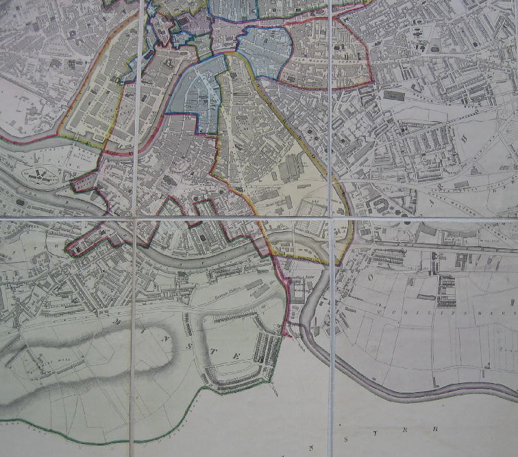
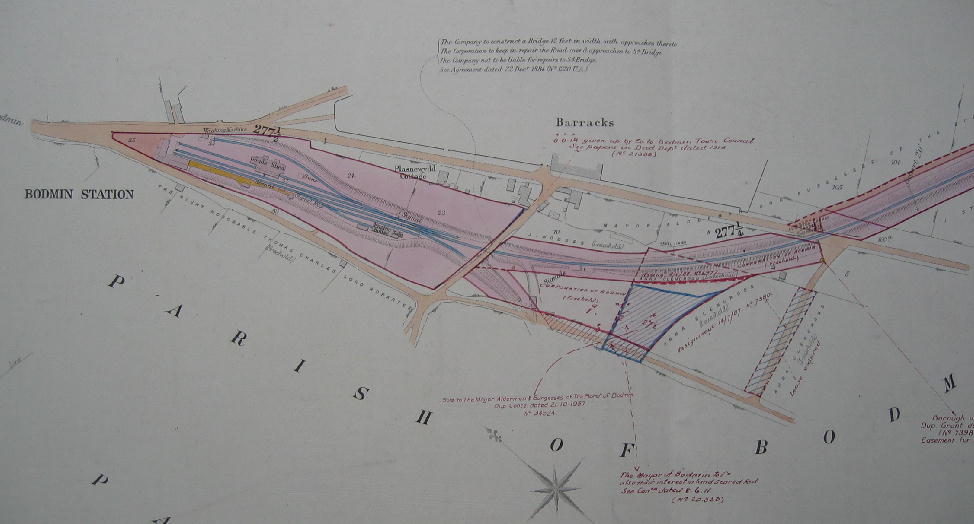
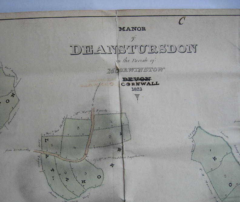
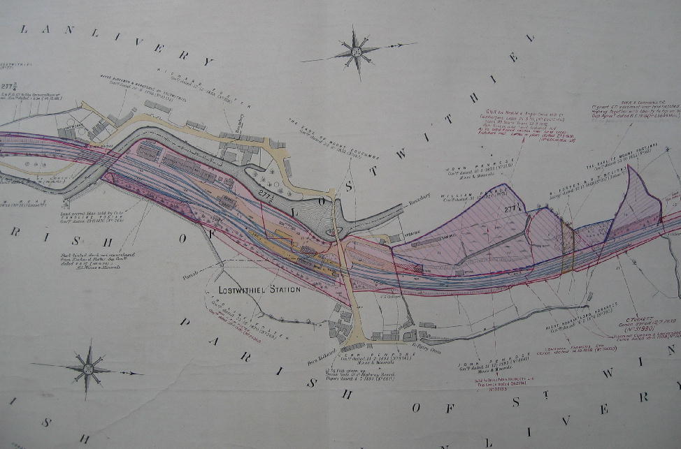
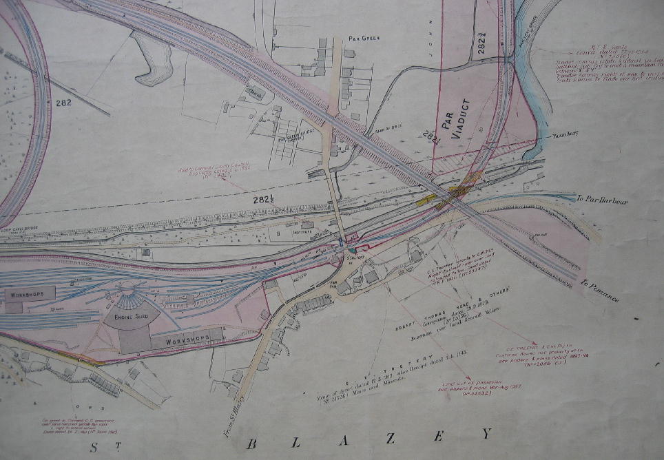
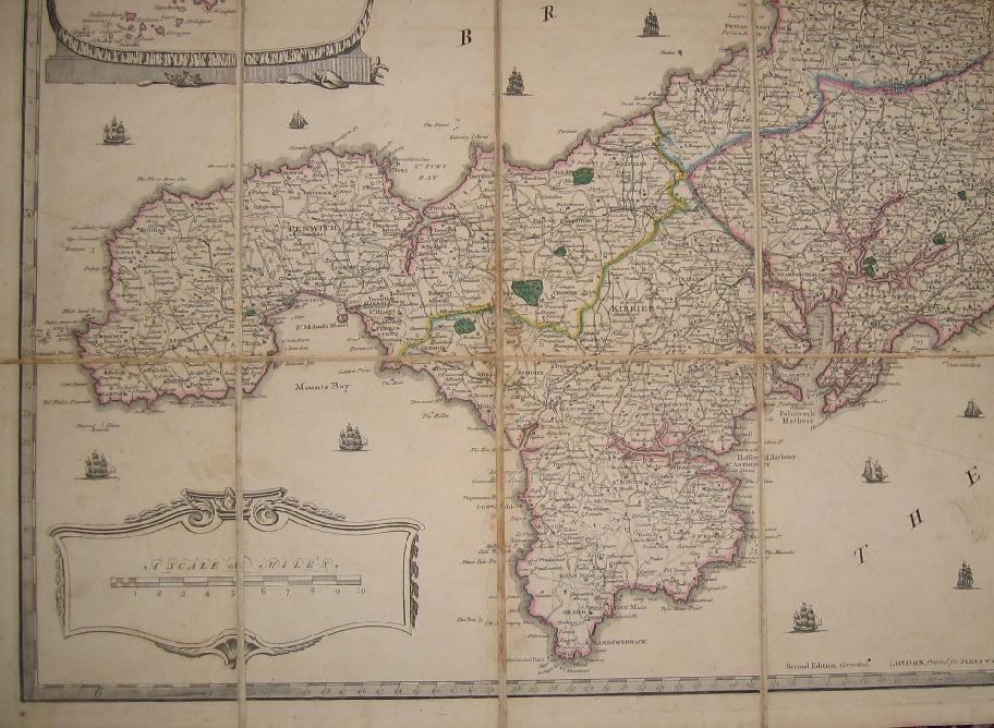
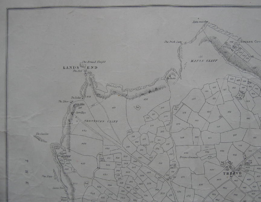
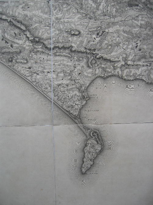
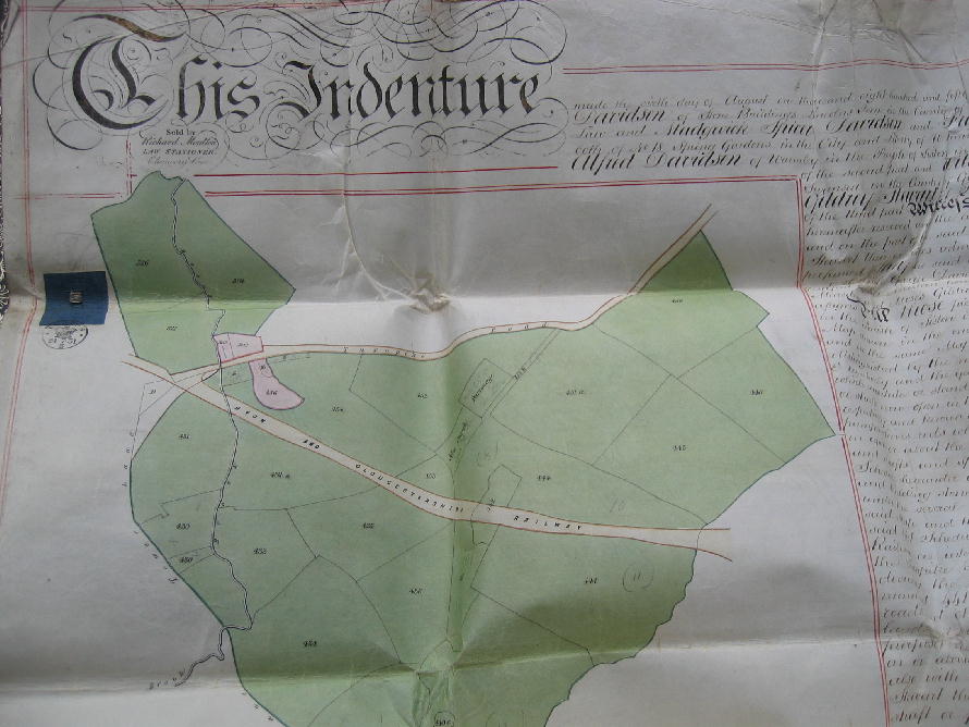
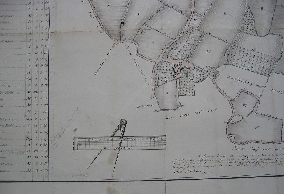
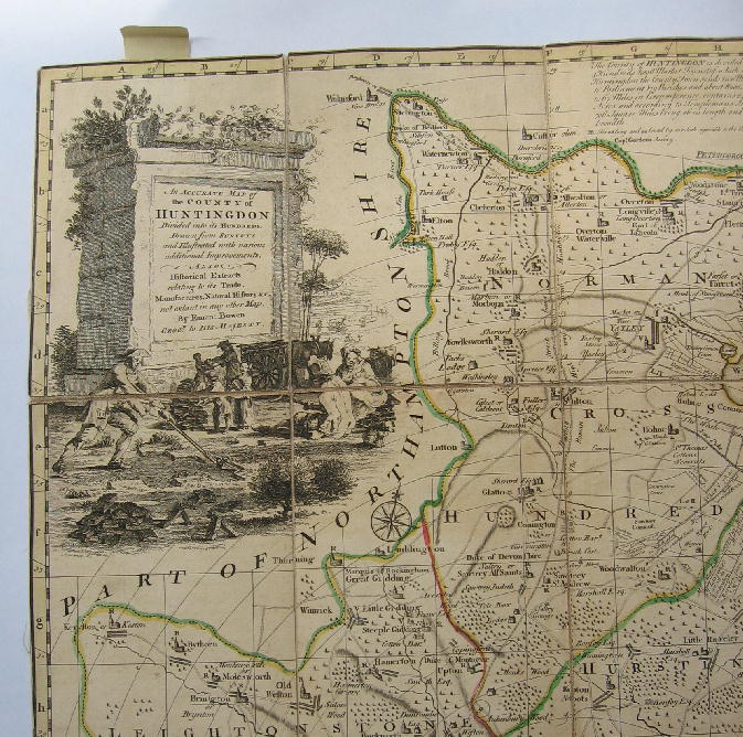
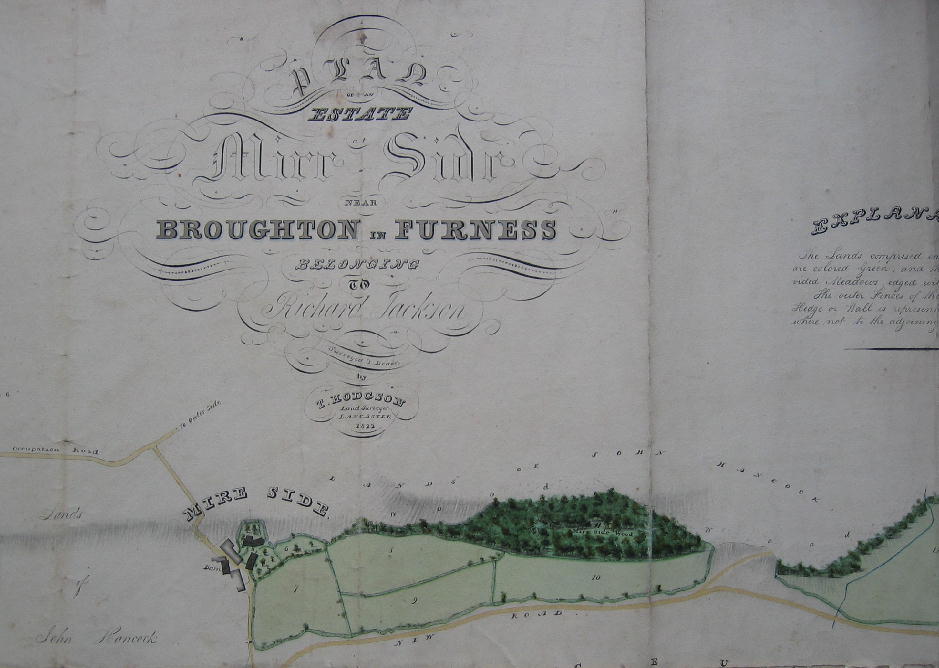
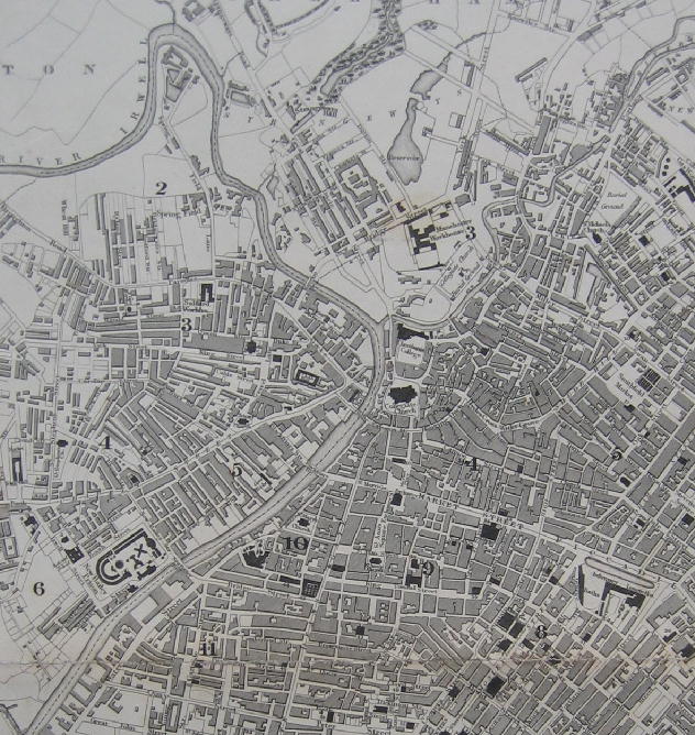
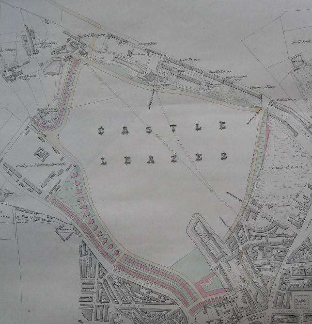
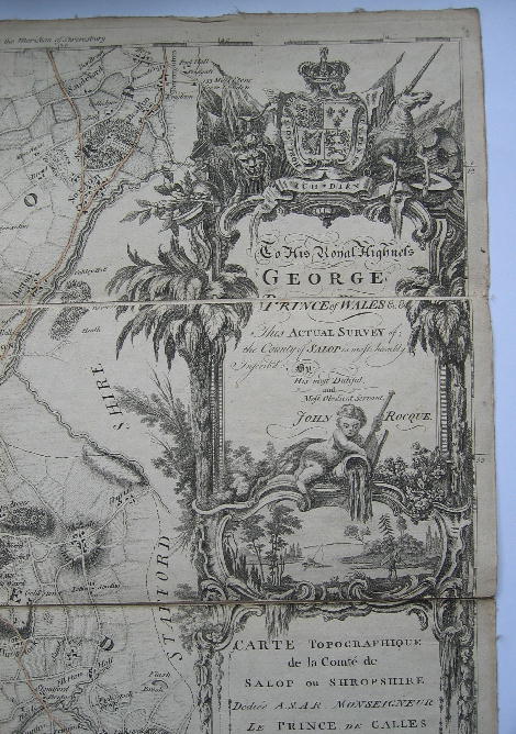
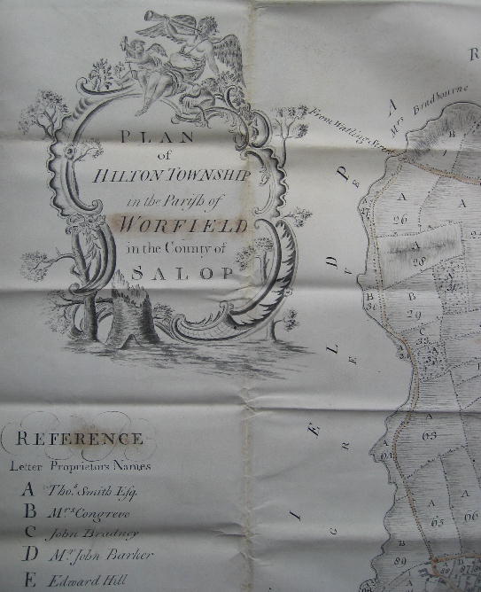
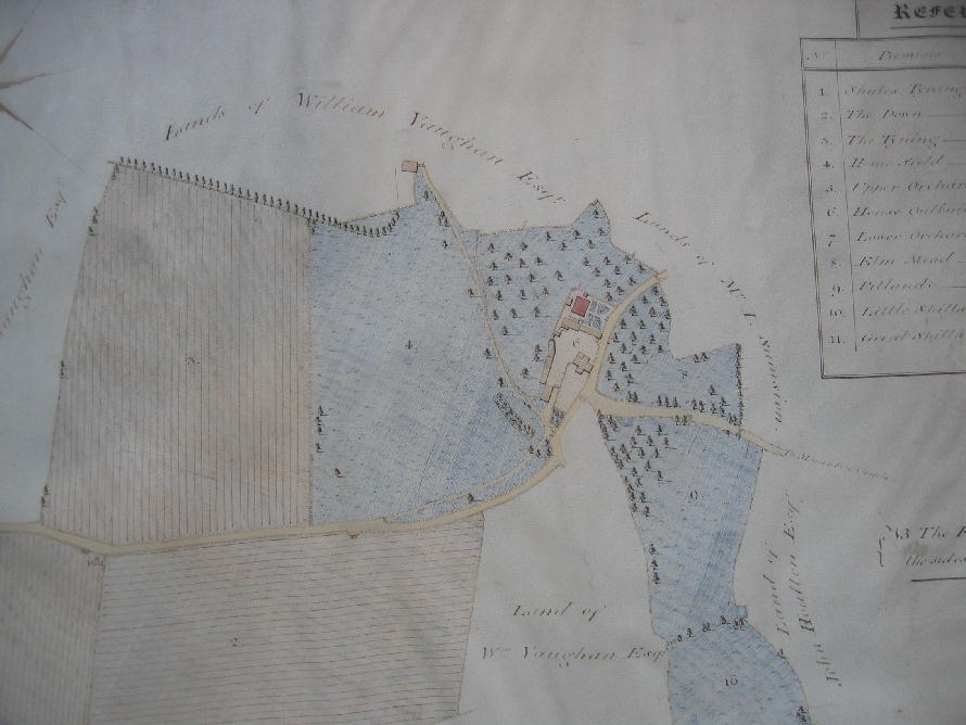
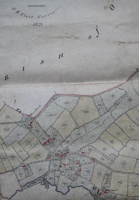
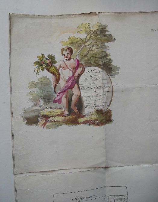
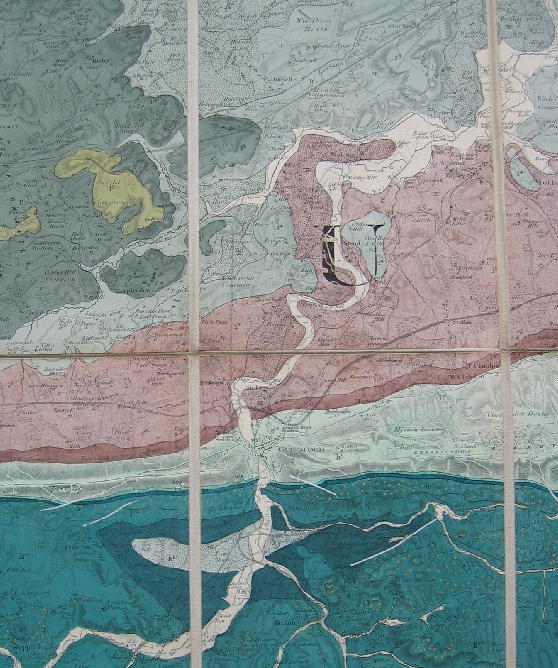
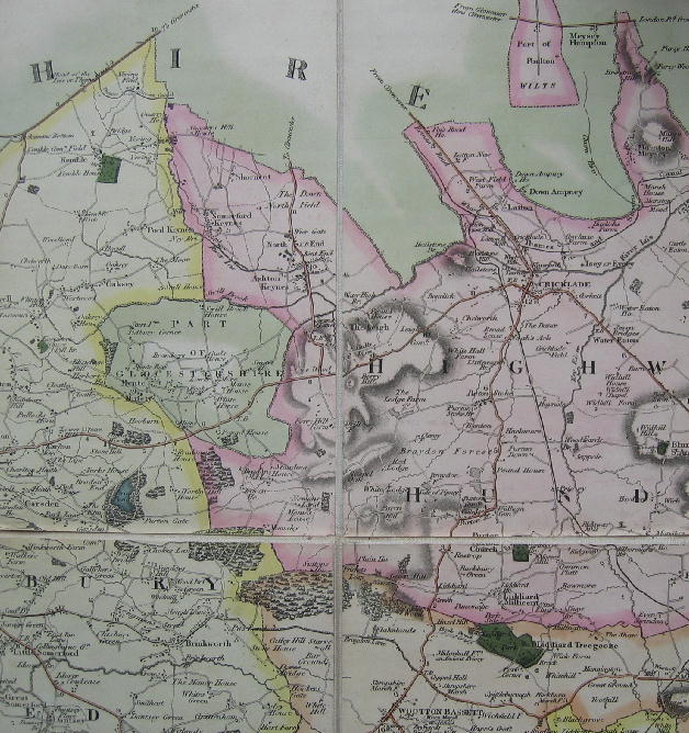
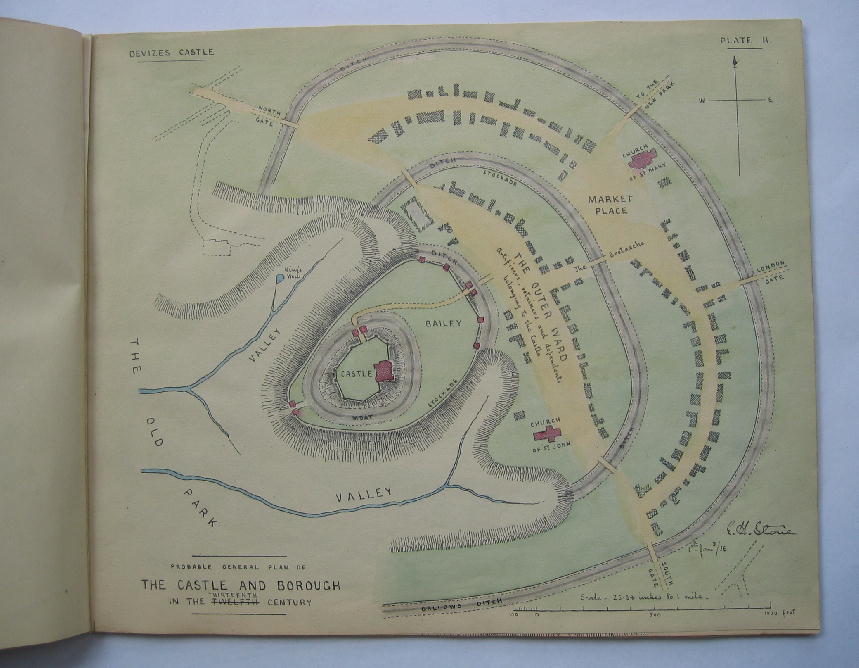
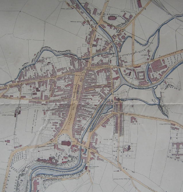
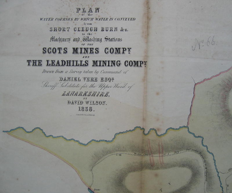
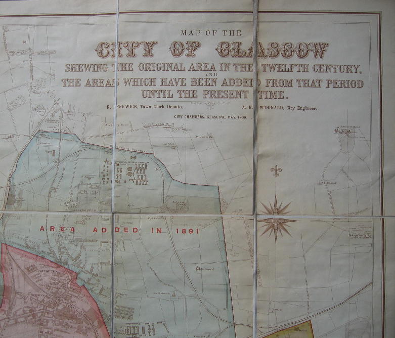
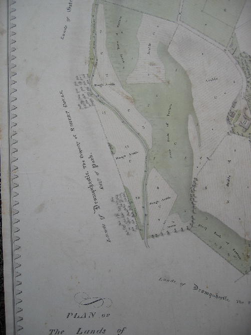
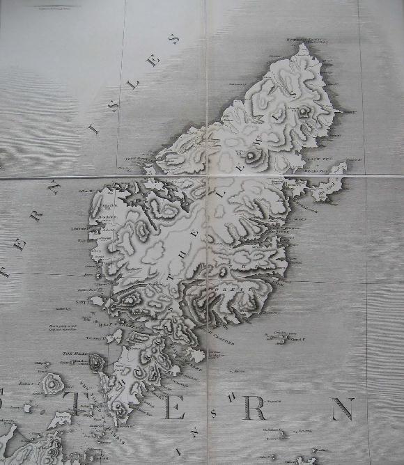
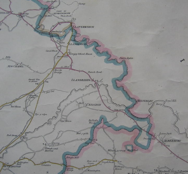
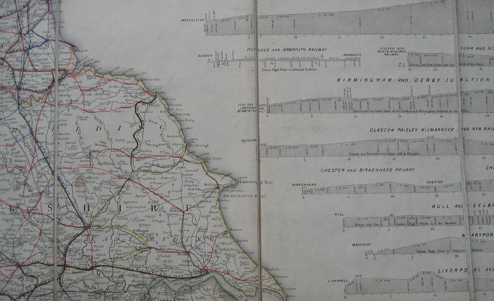