| NOTE:
This is an old catalogue and many of these items are probably sold. Please contact as I may have similar items in stock. It shows the range of items I specialise in BUYING and SELLING. |
Berkshire
Walter (Henry) TO THE KINGS MOST EXCELLENT MAJESTY THIS MAP OF WINDSOR FOREST and Its Vicinity from Actual Survey is humbly dedicated by His Majesty's most dutiful and obedient Subject and Servant H. Walter. Engraved map, size 35" x 47", scale two and three eighths inches to one mile, mounted on linen, on wooden roller, wooden stretcher at top. Map extends to Blackwater, Twyford, Maidenhead, Eton, Staines. Large calligraphic title, compass rose. Shows, parkland, county, parochial and Forest Boundaries, open and enclosed roads and green lanes. Many splits in paper along top 4" of map, some in paper, and some splits in linen, mainly in blank area, with some slight loss of paper at top left margin, split in paper and linen along 10" at top of map at centre, in blank area, with some vertical splits leading downwards from this tear, one of which, approx. 6" long, goes into map area. Light linen pasted across top edge of map on verso to stabilise tears. Paper at top corners of map slightly dusty. Pub. August 2nd 1823 by the Proprietor... Sold by E. Mogg. £250.00
¶ A scarce map. This is the first edition. A new edition was published in 1856.
A further selection of BERKSHIRE Items on Main Site
Back to the Top
Cornwall
Bodmin, Falmouth, Penzance FOUR ORDNANCE SURVEY MAPS Sheets XXX, XXXI, XXXII, XXXIII. Scale 1" to 1 mile, on thick paper, engraved surface approx. 23" x 33, plu wide margins. Folded to 13" x 5". As follows: (i) Sheet XXX. (Corresponds to Margary State 3). Paper slightly darkened, dusty, with some pinholes in margins, and one small pin-hole in printed area, 2" tear in top margin at fold, small repaired tear in map area. (ii) Sheet XXXI. Two or three minor edge tears, two very small tears and some slight rubbing at one point in sea area at central fold. Corresponds to Margary State 3. (iii) Sheet XXXII. Corresponds to Margary State 3. Tear along platemark top left, 10" long, repaired on verso. (This sheet covers the tip of the Lizard only.) (iv) Sheet XXXIII. 1" split at fold, repaired on verso, and a three wormholes in sea area. Two sheets watermarked 1801. None of the sheets have borders. Published 5th Jany. 1813 by Lt. Col. Mudge, Tower. £120.00
¶ 'the imprint date on the Cornish sheets, 5th January 1813, becomes a purely notional one, which may offer a clue to the relative rarity today of early impressions of the sheets' (Harry Margary)
Cawsand MANUSCRIPT MAP of Cawsand Bay. Manuscript map in full watercolour, size 19" x 26", on paper firmly stuck to thick card. Scale bar showing fathoms and miles (10" = 1 mile), small compass arrow. Shows Penlee Point with the proposed pier, with a lighthouse at the end of it, buildings represented in elevation including the tower on Penlee point, old fish house south of Cawsand, houses at Cawsand and Kingsand, Maker Church and the signal house with red flag flying, redoubt west of Maker. Shows roads, wooded area on Redden point with trees, rocky shore, high ground with darker shading. 26 ships shown in plan form in the bay, indicated as being at chain moorings or with their own anchor (tiny anchors and chains shown), and the Napp and Panther rocks. There is a Reference on a decorative scroll bottom right, with explanation of 13 letters on the map. The reference states 'depths at low water figured in the circles' but this has not been done. There is an area about half an inch square in the top left (on the hill above Cawsand) where the paper seems to have been rubbed at some point and possibly painted over at some time - the colour is slightly different. (1798). £420.00
¶ In 1798 Sir J.B. Warren made a proposal to the Admiralty for a pier from Penlee point to protect Cawsand bay 'the best Anchorage for Ships of War and has the greatest depth of Water of any near, and further to the Westward than any other place in the Channel either for bringing squadrons or Convoys...'. Quoted in Elisabeth Stuart's 'Lost Landscapes of Plymouth', which illustrates the 'rudimentary sketch of the Sound' accompanying the proposal, now in the Public Record Office. The map illustrated in Stuart's book is much smaller and sketchier, and at a smaller scale than this one.
Collins (Capt. Grenville) FOWEY & MOUNTS-BAY Is most Humbly Presented & Dedicated To the Right Reverend Father in God Jonathan Lord Bishop of Bristoll... Fully hand-coloured chart, scale 1" to 1 mile, size 17" x 22", plus margins. Large decorative cartouche with coat of arms and figures either side, waves with mermen. Small compass rose, ship bottom left, rhumb lines. Shows Fowey with small houses along coast, Pendennick, Polruan, Menabilly, Coomb, St. Katherine's Castle, Dovehouse, Becon etc. Inset is a plan of Mounts Bay, scale 2 miles to an inch. With section below showing the 'going into Fowey when Fowey Castle beareth N6 W3 Miles', with windmill, castles etc. Trace of central fold. c1740 or earlier. £300.00
Stithians BOOK OF PLANS Nine coloured sketch plans, two on waxed cotton, the others on tracing paper, each size approx. 10" x 10", sewn in plain paper wraps titled 'Stithians' Maps 1862, folded vertically. Fields shaded in different colours, and numbered. Front wrap and first 2 plans spotted with damp, not affecting tissue paper plans. Comprises: Penhalveor, Nampean (this plan with key to field numbers, giving name of field, tithes payable); Crellow (shows many houses, foundry, church, areas marked with tenants' names); Treweege; Treseverne, Treweege, Treskewis (some tenants names marked); Treseverne Estate; Rosemenewas (shows Granite Quarry); Kennal Farm (shows wooded areas); Trembroath, Treskewes; Tregonning, Vellandruckie. 1862. £90.00
Wendron PLAN OF TOLCARNE WARTHA in the Parish of Wendron the property of John Borlase Esq., Surveyed 1832 by P. Priske. Manuscript plan in ink and full wash colour on vellum, size 12" x 17", scale 4 chains to 1", folded. Scale bar, decorative title. Vellum discoloured and spotty from damp. Sewn to the edge are three pages 'Reference to Tolcarne Wortha' (1 with repaired tear), giving number on plan, name of enclosures etc., measurement of hedges and waste, clear ground. Plan shows houses, roads, stream and pool, names of adjoining owners. 1832. £40.00
¶ The lessees were John and Nicholas Reed.
A further selection of CORNWALL Items on Main Site
Back to the Top
Devon
Belstone, Throwley FOUR ORDNANCE SURVEY MAPS Sheets LXXVII S.W., S.E., N.E., N.W. Scale 6" to one mile. Size of each map 12" x 18", plus margins, linen-backed and folding into plain card boards, 8vo. Roads have been hand-coloured. Second Edition 1906. £36.00
¶ Covers South Zeal, Wonson, South Tawton Quarries, Sticklepath, Fatherford.
Mosley (Charles), Sculp. THE CITADEL OF PLYMOUTH To The Hon. Charles Churchill Esqr.... Governour of Plymouth and Member of Parliament for Castle Rising in Norfolk, This View of the Royal Citadel of Plymouth is humbly presented by His Most obliged Grateful & most Obedient servt. Sandford Mace. Finely engraved view, size 18" x 27", plus margins, shows Citadel looking from the sea, large ship bottom right, and boat in harbour, with features such as Guardhouse, Storekeeper's House, New Harbour etc., labelled with small letter, key below, with list of Governors either side of dedication and coat of arms. Inset plan of Plymouth Sound top right, size 6" x 9", and a view of ships in the Sound top left, size 3" x 7", with key. A very feint mark approx. 2" x 1«", in sky area, central fold, some old paper strips placed at fold on verso for reinforcement. Published July 25th, 1737. £700.00 -- See Illustration
¶ A good strong impression. See Somers Cocks ('Devon Topographical Prints') 2014; Stuart ('Lost Landscapes of Plymouth') 95. Scarce.
Senex (John), Harris (John), Wilson (Henry) PLIMOUTH SOUND Engraved map, outline hand-colouring, size 11" x 10«", trimmed to borders and mounted on thick card. Covers area from Mewstone, Penlee Pount, to Kings Dock and Froward Point. Coloured compass rose with rhumb lines at bottom, scale bar (approx. 2«" = 1 mile). Villages etc shown with churches in elevation, houses, coloured red, coast shaded blue and yellow, with beach areas buff. Shows the Citadel, town of Plymouth, Stone House, Mt. Wise, Mt. Edgecombe, White Leate, Stone henge, Maker, Cats Denn, Radford, St. Nicholas Island. Shows soundings. 1728. £60.00
¶ From the scarce 'Atlas Maritimus'. There is no title, and this was probably an inset map.
South Devon GREAT WESTERN RAILWAY. SOUTH DEVON RAILWAY. 2 Chain Survey 1909. 215M to 227M. Vol. 119. Containing 5 sheets Nos. 12-17, hand-coloured lithographically printed, each sheet mounted on linen, size of the volume approx. 25" x 41". Scale 2 chains to 1". Compass rose and scale bar on each sheet. Stiff maroon cloth wraps with morocco spine and gilt lettering on front wrap, approx. one quarter of back wrap missing, wraps chipped at edges, corners of some pages dogeared and worn, in one case with some wear to some words in title of sheet in top right-hand corner, but not to plan. Thos. Kell and Son, Lith., 40 King St., Covent Garden. £270.00
¶ The plans show the route of the railway from the Quarry at Stoneycombe to Totnes, showing Dainton Quarry, Fishacre Mill, Little Hempston Quarry, Totnes Station, buildings and streets in Totnes including Cider Stores, Seven Stars Hotel, Mill Leat, Timber Yard, etc. Detail includes adjacent buildings, houses, signal boxes, goods sheds, cranes, troughs, platforms, tunnels, parish boundaries, woodland, wells, etc. The names of the landowners adjacent are shown with details of leases or conveyances, mineral rights. There are occasional later details of land transactions neatly written in red ink, up to the 1950's. The distance from Paddington is shown at quarter of a mile intervals.
A further selection of DEVON Items on Main Site
Back to the Top
Dorset
Barnstow MAP OF THE MANOR OF BARNSTOW Manuscript map, in ink on paper, backed with linen, mounted on mahogany roller with finials, size 18" x 28". Scale 1" = 4 chains. Sides edged with silk tape. Large title with initials 'G.F.' below in a small garland, large compass rose. Paper slightly darkened uniformly, a few very small chips in paper at top left border, and a few small creases in the middle at the top. c1840. £130.00
¶ Shows roads, stream, buildings, areas with trees, fields, all numbered. Adjoining owners named. Shows stile and footpaths at 'Vere Cross'. A George Forrester is recorded in the 'Dictionary of Land Surveyors' as having worked in Dorset in the 1840's.
Portland ORDNANCE SURVEY MAP Sheet No. XVII. Scale 1" to 1 mile, size 24" x 31", dissected and mounted on linen and folding to 8vo, silk edging tape. 6 small red circles, approx. a quarter of an inch diameter, drawn at various points. c1836. £36.00
¶ Covers Bridport, Dorchester, Lulworth. Corresponds to Margary State 4.
A further selection of DORSET Items on Main Site
Back to the Top
Durham
Chopwell, Ryton PLAN OF AN ESTATE SITUATE AT CHOPWELL in the Parish of Ryton in the County of Durham Belonging to Robert Thorp Esqr. Surveyed by Edward Grace in 1825. Finely drawn manuscript plan in ink and some outline colour, on vellum, size, 32" x 24", edges bound with tape. Large decorative title with variety of calligraphic styles, scale bar (5" = 20 Chains), compass rose, Reference Table on left listing fields etc. with acreage for Horse Gate Farm, Broom Field Farm, Chopwell Hall Farm, Plantations. Areas of different farms outlined in colour. Shows buildings, plantations with numerous neatly-drawn trees, streams, high ground with light hachuring in watercolour, small mounds indicated in some fields, adjoining owners named. Field names and acreage given on map. Small water-stain bottom left, and small grey spots along bottom border and on Reference Table, with some slight cockling of vellum, area of dark grey spotting over compass arrow, thin line of spotting half way across top edge. Staining does not affect legibility. Verso of plan very dusty at bottom 12". 1825. £200.00
¶ Shows Chopwell Hall, Horse Gate Broom Fields, Mason's House. Areas of different farms outlined in colour.
ARMOURER DONKIN'S COPY Greenwood (C.G) MAP OF THE COUNTY PALATINE OF DURHAM From An Actual Survey Made in the Years 1818 & 1819 By C. Greenwood, Dedicated to the Nobility, Clergy & Gentry of the County by the Proprietors Greenwood, Pringle & Co.... 1st August 1820. Engraved map, scale 1" to 1 mile, on two sheets, dissected and mounted on linen, each sheet size 20" x 50", folding to 10" x 9", edged with silk tape, small morocco label with sheet number. In card slip case with book plate of Armourer Donkin, inserted in blindstamped calf slip case, rubbed, lacks calf on one narrow edge. With compass rose, large vignette view of Durham looking across city from fields with cows, etc., Explanation, List of polling places. Outline colouring of boundaries of wards. The map is the slightly later issue of the first edition, with railways, coloured in red and shaded in yellow, pink, blue, some lines marked with dotted lines, some small branch lines shown with thin blue line with no shading. c1825. £750.00 -- See Illustration
¶ Railways include Stockton and Darlington, Clarence Railway, Great North of England (southern part is a dotted line), Stanhope and Tyne, Durham and Sunderland, Durham Junction, Brandling Junction (dotted line). There is a pencil note near the title 'joins the Lancaster and Carlisle by which with other railways there is a direct communication with Liverpool'. Some railways drawn in yellow and nun-named. Armourer Donkin (1779-1851) was a prominent Newcastle solicitor, friend of writers and artists such as Leigh Hunt, William Cobbett, Baily the sculptor, mentor of William Armstrong the engineer.
LARGE SCALE HAND-COLOURED MAP Hobson (William Colling) THIS MAP OF THE COUNTY PALATINE OF DURHAM, is most respectfully dedicated to the Nobility, Clergy, Gentry, &c. &c. Large engraved map, fully hand-coloured in hundreds, scale three-quarters of an inch to 1 mile, engraved surface approx. 31" x 39", plus margins. Dissected and mounted on linen, folding to roy 8vo, contained within a contemporary grained cloth box, in the form of a book, leather lettering piece on spine. Some slight off-setting, a few small foxing marks, names of previous owner written twice in ink in top margin. Engraved by J. & C. Walker. 1840. £360.00
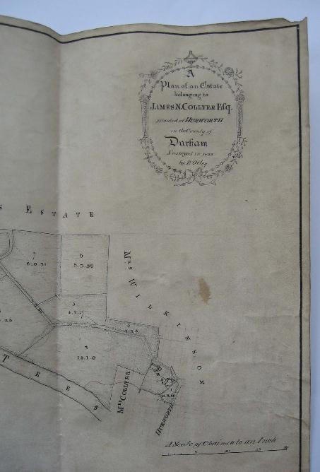
Hurworth A PLAN OF AN ESTATE BELONGING TO JAMES N. COLLYER ESQ. SITUATED AT HURWORTH in the County of Durham Surveyed in 1825 by R. Otley. Hand drawn plan in ink on vellum, size approx. 12«" x 21«", scale 6 chains to an inch, decorative cartouche, table listing the land and acreage, and a second table listing the acreage of the river and bank. The land borders the River Tees. Very slightly dusty. 1825. £110.00 -- See Illustration
¶ An R. Otley is listed in Eden's 'Dictionary of Land Surveyors' as working in North Yorkshire and being 'prominent in the development of Middlesborough with Henry Pease'.
A further selection of DURHAM Items on Main Site
Back to the Top
Essex
South Weald CONVEYANCE of Hullets Farm in the Parish of South Weald, Revd. Arthur Trazer and Emanuel Keating to Arthur Toovey. Four vellum sheets, size 20" x 26", wax seals, with schedules of fields, etc., plus good manuscript plan on vellum, fully coloured, size 19«" x 29", with nos. referring to schedules. Plan shows Bentley Mill, Pilgrim Hall, Hullets Farm, Canterbury Tye Farm. 1866. £65.00
A further selection of ESSEX Items on Main Site
Back to the Top
Gloucestershire
FIRST LARGE-SCALE MAP OF THE COUNTY Taylor (Isaac) TO THE SUBSCRIBERS IN GENERAL, AND MORE PARTICULARLY TO THOSE NOBLEMEN AND GENTLEMEN WHO HONOURED ME WITH THEIR ASSISTANCE IN THE SURVEY; THIS MAP OF THE COUNTY OF GLOUCESTER, Is Humbly Dedicated By Their Obedient & Most Humble Servant Isaac Taylor. Large copper-engraved map, with full original wash colour, size of map approx. 53" x 47", linen-backed. Scale: 4 miles = 3 and three-quarters inches. Very large ornate title cartouche, 18" high, showing river with boat being unloaded, smoking kilns, masts of a sailing ship, barrels, basket of apples, net of salmon, bales of cloth, classical figure with scroll, Explanation, Scale bar, Compass rose. In top left-hand corner are five views of Berkeley, Beverstone, St. Briavels, Sudeley, and Thornbury Castles. Trimmed to border at top and butted up against a large sheet of paper with ribbon edging. The silk ribbon edging has disappeared from the map itself. Slight crease at top of cartouche. First edition. Ross, March 10, 1777. £2200.00
¶ RARE. 'The first map of the county on a large scale, beautifully engraved, giving minute details.... This is an entirely new survey, from which all succeeding maps down to the Ordnance Survey of 1828-31, were compiled. Shows towns, villages, hamlets, churches, chapels, religious houses, gentlemen's seats and houses (in some cases the names of the occupier is given), inns, camps, sites of battles, commons, hills, hundreds, forests, woods, parks, fire engines, forges, coalpits, watermills, windmills, roads, rivers and bridges...' See Chubb's Descriptive Catalogue of the Printed Maps of Gloucestershire, pages 74 and 75. Chubb also gives a brief outline of Isaac Taylor's life.
A further selection of GLOUCESTERSHIRE Items on Main Site
Back to the Top
Lancashire
Hopwood (William), Surveyor, Blackburn PLAN OF A PROPOSED PUBLIC PARK IN BLACKBURN 1854. Engraved plan, area of park fully hand-coloured in fine watercolour. On very thin paper, backed with stiff paper, and mounted on linen, blue silk edging tape. Size 25" x 25", scale 300 yds = 5". Large and very decorative title, scale bar, compass rose. Shows surrounding area extending to Four Lane Ends, King William Street, Spring Mount, Revidge Lane Ends. Shows roads, quarries, areas with trees, buildings with garden layout in detail (for example the garden plots at the back of Wellington Street houses, the garden at 'Spring Mount'). There is a Reference Table giving key to outline colours indicating land ownership. The layout of the park is shown in detail with lakes, fountain, stream, wooded areas beautifully coloured with variety of trees, paths, proposed carriage roads, steep areas. Small tear in surface top right, at border, with tiny piece of paper lost (in blank area), a few small creases in top and bottom margins. 1854. £220.00
¶ Among the large properties shown are Sod Hall, Wagtail, Shear Bank, Little London. Mayor Thomas Dugdale proposed the park in 1854. Joseph Feilden sold 50 acres of his land to the Council, and work began in 1855. It was opened on 22nd October 1857, 60,000 attending.
Newlands (James), Compiled by PLAN OF THE BOROUGH OF LIVERPOOL With Contour Lines at Every 4 Feet of Altitude, Compiled by James Newlands, Borough Engineer. Borough Engineer's Office, Cornwallis St., Liverpool. January 1849. Lithographed plan on stiff paper, size 23" x 38", contour lines in red, with figures. Scale 1" = 10 chains. Large decorative calligraphic title, compass rose, scale bar in chains and yards. Some feint spotting down right hand edge, approx. 5" into map. Small repair to margin in top right corner. Published by Wareing Webb, Castle Street, Liverpool. 1849. £200.00
¶ Lithographed by Maclure, Macdonald and MacGregor, Lithographers, Draughtsmen and Engravers, Liverpool
Phillips PHILLIPS' NEW MAP OF LIVERPOOL, and its Environs. Completed from Actual Survey 1881. Coloured folding plan, coloured in wards, dissected and mounted on linen, size approx. 43" x 60", including margins, scale 6" to 1 mile, folding into the original cloth boards, 4to, gilt title, marbled endpapers, covers slightly rubbed at edges, with a couple of short splits to outer hinges, decorative borders to plan, and a Reference Table of churches, banks, public building, cemeteries, places of amusement, railway stations, etc. Decorative border with leaves etc., compass rose. London: George Phillip and Son, 32 Fleet St., Liverpool: Phillip Son and Nephew, Atlas Buildings, 49 and 51 South Castle St., 1881. £240.00
¶ Covers area from Thingwall in the North to Hamilton Square. A very detailed map which is fully coloured.
Witton, Blackburn A MAP OF LANDS BELONGING TO THE REVD. THOMAS HOLME Lying in Witton in the Parish of Blackburn & County of Lancaster by R. Lang. A.D. 1728. Manuscript plan in black ink and watercolour, on paper, backed with linen, size 20" x 29". Scale bar with dividers at bottom centre, 'A Scale containing one Quarter of a Mile or Eighty Poles, at Seven Yards pr. pole according to the Map' (6" = approx. 80 Poles). Dividers 6" high in gold, highlighted red. The title is extremely decorative, in a panel 6" deep at the top, with a large red rose, swags of leaves and buds in bright green, title in very large letters in contrasting calligraphic styles, the initials of 'Thomas Holme' being very ornate. Plan divided into squares with letters down left and along top. Shows roads, river, fields (each field with name), paths, buildings, wooded areas, orchards etc. Houses are shown in elevation and coloured pink with grey roofs. 'Explanation' bottom right with decorative title, explaining how to use the letters 'in the Margent... for finding any Close' and a key giving the letter references for 'Witton Demesne' 'Buncers Tenement', 'Walkedens Tenement', 'Stocks Tenement', 'Ratcliff Cottage', and key to indication of 'Water pitts, Pitts growing Arable, Footpaths, Rivers, Woods or Rough, Driving Roads, High Roads or Lanes, Boundary fences'. Key to adjoining owners at left. Large decorative compass rose (north-south is aligned to horizontally) in blue, gold and red. Some surface dusting, piece of paper (not linen) missing at left border, approx. 2" square, with loss of part of border and red line of square, but no other text. Several tears in paper at top margin, including one with some wear, tear in paper only in blank area on right, approx. 4" long with some slight wear at one point, and some tears with slight wear at right hand edge outside border, a few cracks in paper. Slight smudging of red colour on the dividers, and some off-setting of this colour at left margin, presumably where rolled. 1738. £560.00
¶ The house was rebuilt in 1800. The estate was acquired by the city in 1946.
A further selection of LANCASHIRE Items on Main Site
Back to the Top
Lincolnshire
Greetham, Ashby Puerorum etc. PLAN OF ESTATES THE PROPERTY OF STEVENS DINELEY TOTTON ESQ. in the Parishes of Greetham, Ashby Puerorum and Salmonby. Manuscript plan in ink and outline colour, on thick paper dissected and mounted on linen, folding to large 4to. Size 65" x 90". Calligraphic title. Buildings, water-features and roads coloured, fields shaded in lines to show cultivation, rough ground indicated. Hedges shown. Parish boundaries shaded. Each building and field is numbered but there is no key. n.d. c1840. £300.00
¶ The Totton family were mercers from Spitalfields.
A further selection of LINCOLNSHIRE Items on Main Site
Back to the Top
London
Bermondsey A MAP OF THE PARISH OF ST. MARY MAGDALEN BERMONDSEY from the last Survey Corrected by Jno. Pullen, Engrav'd by Jno. Harris. Copper engraved plan, hand-coloured, from Stow's 'Survey', size 11" x 14", plus wide margins, overall size 15«" x 20". With reference table to Alleys, Courts, Rents, etc., and Table of the Names of Streets, Lanes. Church shown in elevation. Scale bar and compass rose. Trace of central fold. 1755. £115.00
¶ Shows River Thames, three Rope Walks in the east, Savorys Dock, Five Foot Lane, Long Lane, London Street.
Davies' MAP OF THE ENVIRONS OF LONDON Map size 29" x 42", scale 1" to 1 mile, dissected and mounted on linen, folding into 8vo blindstamped cloth-covered boards, gilt title. Main roads, railways, river Thames, parkland hand-coloured, county of Middlesex lightly shaded, county boundaries with thick lines of shading. Concentric circles show distances from Charing Cross and The Post Office. Railways named, postal districts shown. Some light foxing spots in top corner sections. Published by Edward Stanford. n.d. c1870. £160.00
¶ Covers Windsor, Potters Bar, Greenhithe, Leatherhead.
Greenwood (Christoper) and (John) MAP OF LONDON, From an actual Survey made in the Years 1824, 1825 and 1826. Large engraved folding map, with the original hand colouring, scale approx. 8" to 1 mile, dissected and mounted on linen, with engraved vignette views of St. Paul's Cathedral and Westminster Abbey. Engraved surface approx. 49" x 72", plus margins, silk tape edging, folding to royal 8vo, marbled endpapers, a couple of the dissected sheets slightly creased, enclosed in a calf slipcase in the form of a book, surface of calf worn, leather label on spine slightly chipped at edges. First edition. Published by the Proprietors, Greenwood, Pringle and Co., 13 Regent Street, Pall Mall, August 21st 1827. £4200.00
¶ See Darlington and Howgego's 'Printed Maps of London', no. 309.
Peckham, Deptford ORDNANCE SURVEY MAP Reduced from the Skeleton Plans. Sheet 28. Scale 12" to 1 mile. Size 25" x 40", dissected and mounted on linen, folding into 8vo endpapers. Drawn and Engraved in 1848-51. £30.00
¶ Covers Blue Anchor Road to Peckham Rye. These maps show only streets, which are all named, and main features such canals, railways.
St. Catherine's THE TOWER AND ST. CATHERINS taken from the Last Survey With Corrections. Copper-engraved plan, hand-coloured, size 11" x 14", plus wide margins, overall size 16" x 24", taken from Stowe's Survey of London. Shows the River Thames with ships and rowing boats, view of the Tower, shown with elevation, All Hallows and St. Catherine's Churches and Navy Office also shown in elevation. With decorative title cartouche, Reference Table of 65 Alleys, Courts, Yards etc. Scale bar. Published according to Act of Parliament 1754 for Stowes Survey. £140.00
A further selection of LONDON Items on Main Site
Back to the Top
Northumberland
Acomb, near Hexham PLAN OF ACOMB COMMON within the Regality or Manor of Hexham in the County of Northumberland; as the same is now Divided and set out, according to an Act of Parliament of the XVIII. Geo. III. Manuscript plan in ink and outline wash colour, size 28" x 45", on thick paper backed with line, remains of silk edging tape on sides, decorative title, with scroll border, decorative scale of chains (4 to an inch). Some slight browning at left side, in blank area. c1800, or slightly earlier. £275.00
¶ Shows named roads, (Pensley Gate Road, Stagshawbank Road, etc.), Birky and Works Burn, Public Quarry, Lead Mill, Mill Dam, Fell Syke, buildings at Acomb, various 'gates'. Plots with name of owner in large lettering with decorative flourish, with acreage. Plots outlined in green or pink, some with note of an exchange. Owners include James Kirsop, Simon Mewburn, Sir Thomas Blackett, Christopher Soulsby, Isabel and Francis Bacon.
Bothal PLAN OF BOTHAL DEMESNE LANDS in the County of Northumberland, belonging to His Grace the Duke of Portland. Manuscript plan in ink on paper, size 13«" x 18", slight wear to folds, some off-setting, couple of small holes to blank area to lower corner, back of plan slightly dusty. With names of fields, showing acreage, table listing 'Names of Farms', 'Names of Tenants', and acreage. The land is partly bordered by the River Wansbeck, shows names of the lands, or parishes bordering the Duke's land. c.1820. £70.00
¶ Bothal is just to the south of Pegswood.
Hebron PLAN OF DEMESNE LANDS IN THE CHAPELRY OF HEBRON in the County of Northumberland, belonging to His Grace the Duke of Portland. Manuscript plan in ink on paper, size 18«" x 13«", folded, some off-setting, couple of small holes to adjacent to ttle. With names of fields, showing acreage, table listing 'Names of Farms', 'Names of Tenants', and acreage. Shows names of the lands, or parishes bordering the Duke's land, occasionally with names of owners. c.1820. £75.00
A further selection of NORTHUMBERLAND Items on Main Site
Back to the Top
Somerset
Bath Pictorial & Bath Chronicle HISTORIC MAP OF BATH Prepared by T. Sturge Cotterell. Folding map printed in three colours, size 17" x 12", plus wide margins, linen-backed and folding into 8vo boards with gilt title and coat of arms. With detailed key to 96 famous people associated with the city, and where they lived, and information on the main buildings. Pin holes and rust marks at bottom corners. Revised to December 1898. £34.00
Bruton PLAN, SECTION AND BOOK OF REFERENCE of so Much of the Wilts. Somerset & Weymouth Railway (Amendment No. 1) Bruton Deviation, As Relates to the Parish of Bruton, 1846. Printed wraps, size 21" x 15", sewn at edge. Comprises:- Private Bills, Standing Orders of the House of Lords, 2pp., small folio; 4p. of Schedules, Folio, written on one side only, giving number on Plan, Description of Property, Owner, Lessee, Occupier (includes Sheephouse Farm Extra Parochial); 2 lithographed plans showing the area of land required shaded pink, Bruton Deviation No. 1, size 17" x10", Bruton Deviation No. 2, size 17" x 26". Repaired 6" tear in blank area of Plan 2. Shows Gants Mill, Church and Vicarage, Sheephouse Farm, Quarry etc. Properties marked with numbers referring to Schedules; 2 folding sheets of sections, each 9" x 27". Plans engraved on stiff paper. 1846. £130.00
¶ The Engineer for the line was I.K. Brunel.
Harcourt Masters (C) MAP OF 24 MILES ROUND THE CITY OF BATH Most humbly dedicated to the Residents and Visitors by their obedient Servant C. Harcourt Masters. Engraved map with some hand-colouring, scale 2 miles to an inch, size 23" x 24", dissected and mounted on linen, folding to 4to. Parkland and major rivers hand-coloured, county boundaries outlined in colour. An early owner has coloured the Fosse Way in light pink, and labelled it neatly 'Fosse Rd', and added 'Via Julia' and 'Via Badonica'. There are three small crosses marking places. No date, probably 1790's. £110.00
¶ Map extends to Tintern, Cirencester, Salisbury, Somerton. Harcourt Masters was an architect. He planned Sydney Gardens in Bath in 1795.
Hayward (S) and Son, Princes' Buildings, Publishers A REPRODUCTION IN WOODBURY-TYPE OF GILMORE'S MAP OF BATH, 1694 With Historical Description. Dedicated to John Stone, Town Clerk of the City of Bath. Map size 30" x 40", dissected and mounted on linen, inserted in 4to slipcase with printed label, rubbed at edges. c1880. £60.00
King (J) MAP OF THE PARISH OF AXBRIDGE in the County of Somerset copied by Jn. King 1843. Manuscript map in brownish ink on thick paper backed with linen. Size 21" x 57". The village itself at the centre with the surrounding fields extending to the parish boundary, title, large compass rose (north on the right). Shows buildings with garden plots, roads, footpaths, fields, church, Axbridge Union House. Each plot numbered. 1843. £120.00
¶ Possibly copied from the Tithe map.
Minehead A PLAN OF THE MANOR OF MINEHEAD Scale 5 Chains to an Inch. Manuscript plan in ink and some wash colour (the lands not in the Manor are shaded in full wash), on paper, size 28" x 35", drawing covering right to the edges of the paper, dissected and mounted on linen, folding into contemporary marbled boards, reversed calf spine, lettered 'East Side from Bratton Manor'. Shows the town and surrounding area, from the coast to the boundary with Bratton Manor, showing the streets (named in central area), the Quay, Puddle Bridge, Market Cross, Pinns Well, Insets of 'Greenlay' and 'Part of the Manor lying on the south side of Oway Hill'. Plan divided into squares with numbers at sides and letters at top for reference. Each building shown in shaded blocks, the church drawn in elevation. Tenement plots are named and numbered, (up to 294) most with name of occupier - for example 'Four Acres Field' is divided into small strips noted as 'Dymonds late Clothiers', Blakes late Burchers' etc. Some plots labelled in faded reddish ink 'in Demesne'. 'Explanation' bottom right with key to colouring of non-Manorial, Glebe lands, etc.... Together with... PLAN OF MINEHEAD TOWN in ink on paper, size 34" x 20", no scale bar or title, dissected and mounted on linen, bound as above, lettered 'Town' on spine. Two small holes in linen between sections. Divided into squares, 'a-k' along top, '1-18' at left side. In three parts: top right is the Quay and Pier, indicating Lime Kiln, and Conduit, in the centre is Middle Street, Hanmans Lane, Church Yard, Vicarage St., Bowling Green, Post Boy, Herringboat Lane etc., and un-named streets, at the bottom is Bampton Street, Puddle Street, Holloway, Butts, Puddle Bridge, Town Hall, New Road to Quay. Each building shown neatly outlined with double line and shaded. Orchard plots, crofts etc. shown. Buildings numbered. 2 items. c1800, possibly earlier. £650.00
Savage (J) and Meyler (W) A MAP OF 5 MILES ROUND THE CITY OF BATH On a Scale of one Inch & half to a Mile from an Actual Survey Including all the New Roads, with Alterations & Improvements to the present time 1805. Printed for and Sold by J. Savage & W. Meyler, Booksellers of whom may be had a New Plan of the City of Bath with the Additional Buildings. Engraved map, size 17" x 17", dissected and mounted on linen, folding to 6" x 3", in cloth-covered slip-case. Map in circular form, with Bath at the centre, with double line around marked with compass points, compass arrow at top. With Explanation bottom right to Turnpike, Common, and Open Roads, and County Boundaries. Shows woodlands, farms, villages and settlements, bridges, with small illustrations of churches. Shows Coal Canal, Kennet and Avon Canal, Lime Kiln, Mills (including Stone Mill and Paper Mill), Stone Quarries, 'Mr. Harrington's Coal Works', 'Vineyard' near Claverton, Brass Works, 'a Glass House', 'a Curious Cavern' etc. Bath. Published according to Act of Parliament March 25th, 1805. £250.00
¶ Extends to Beggeridge in the south, Stanton Prior in the west, Cold Aston in the north, and Henley in the east.
Wilts. Somerset and Weymouth Railway TRACING OF PROPOSED RAILWAY FROM PITCOMBE TO BRUTON with names of Owners through the proposed lands to be taken. Recd. from Mr. Peniston 21 March 1848. Finely drawn plan in ink and three colours on tracing paper, size 17" x 33", folded with docket title, signed 'J. Peters Yeovil, 18.3.48' bottom right. Scale 4 chains to an inch... together with a small plan size 7" x 11" on tracing paper, scale 4 chains to an inch, showing two areas of land bordering the line at Pitcombe. 1848. £60.00
¶ Shows the line in pink, with roads, river, buildings, wooded areas, names of owners.
A further selection of SOMERSET Items on Main Site
Back to the Top
Suffolk
Burstall, Sproughton TWO ORDNANCE SURVEY MAPS Sheets LXXV.9 and LXXV.10. Scale 25" to 1 mile, size 25" x 36". Linen-backed, cloth endpapers, dissected and folding into cloth covered slip-case, size 10" x 8". Water features, roads and buildings hand-coloured. Zincographed and published 1882. £42.00
¶ Covers Burstall, Burstal Hall, Grove Farm, Brick Works, Sproughton, Sproughton Hall, The Chantry Ross Hall, Crane Hall.
A further selection of SUFFOLK Items on Main Site
Back to the Top
Surrey
North Downs, Weald GEOLOGICAL SURVEY Sheet No. VIII. Fully hand-coloured map, size 24" x 36", scale 1" to 1 mile, key in margin. Linen-backed, folding into marbled wraps which are faded and rubbed, Stanford label. Geologically surveyed the Secondary rocks by F. Drew, the Tertiary beds by T.R. Polwhele... Published 1862. The Drift surveyed by W. Whitaker... Published December 1887. £95.00 -- See Illustration
Prees Heath ARTILLERY TRAINING MAP Ordnance Survey, 1916. Scale 1:20,000. Scale bar in yards and metres at bottom, with table for converting metres to feet. Sheet size 19" x 16" plus wide margins, folds, repaired tear at right margin stretching 2" into map. Contours printed in brown, divided into 36 numbered squares. Instructions as to the use of the squares at bottom. 1916. £18.00
¶ Covers Prees, Tilstock, Hanmer.
Sutton CONVEYANCE of hereditaments in the Parish of Sutton, E. Clapham to Miss J. Worrell. 2 large vellum sheets, 3 wax seals, the second sheet being a fully coloured manuscript plan, size 19" x 26", scale 4«" = 400ft. Scale bar, compass rose. Plan shows plots near St. James Road and Sydney Road, shows rows of trees, buildings, pool, garden paths etc. Adjacent owners named. 1895. £46.00
Weybridge ORDNANCE SURVEY MAP Scale 6in. to 1 mile. Composite map, size 36" x 60", no borders, dissected and mounted on linen, folding into 8vo marbled wraps, printed label with manuscript inscription 'Surrey Corps of Guides', wraps slightly rubbed at edges. Water features hand coloured, large area of map outlined with thin pink wash line. c1900. £40.00
¶ Covers Oxshott, Chertsey, Bushy Park, Hersham.
A further selection of SURREY Items on Main Site
Back to the Top
Wiltshire
Blaeu (W) WILTONIA sive Comitatus Wiltoniensis. Wiltshire. Handcoloured engraved map, size 15" x 19", plus margins. Dutch text on verso. Attractive title cartouche flanked by two men, one carrying a musket and the other a pike, scale bar bottom right with horseman, cherub and another figure who seems to be engaged in measuring, 14 coloured armorial shields at left, plus two blank shields. Central fold. n.d. c1664. £275.00
¶ Shows towns, villages, churches, hundreds, hills, parks, forests, woods, moors, rivers, bridges.
Box PLAN OF THE PARISH OF BOX County of Wilts. and of the Parish of Ditchridge intermixed therewith in the same county, comprising the Manors of Box, Ditchridge and Haselbury. 1841. Manuscript plan size 9" x 11", very finely drawn, in ink and full wash colour in 5 shades. Decorative title, compass rose, scale bar (scale approx 2" = 65 chains), map shown as if on a wooden roller, with roller at the bottom with fancy finials and blue ribbon ties, small decorative ornament on wooden batten at top, which is picked out in gold, as are the finials below. Shows roads, rivers, buildings, Ancient Roman Road, Great Western Railway with tunnel marked and six shafts. Shows Box and Haselbury Quarries, Browning Mill, horse and Jockey at Wormwood. Lands coloured 'green in Box parish, red in Ditchridge'. 1841. £160.00
¶ The Box tunnel opened in June 1841.
Charles Baker, Painswick MAP OF THE PARISH OF NETTLETON in the County of Wilts. 1839. Manuscript map in ink and some colour, size approx. 68" x 60", on thick paper backed with linen. Mounted on mahogany roller. Title, large compass rose, scale bar (scale 5 chains = 2 inches). Water-stain down 18" at edge at top left, reaching a maximum of 3" into the map, some light brown damp spots in places. Map detached from wooden lath at top along 18", wear and tears at top, one tear stretching into map area, some creasing, particularly at top, line of rust spots along bottom where nails on roller have left marks when map rolled. Charles Baker, Painswick, 20th June, 1839. £300.00
¶ Shows roads, river, footpaths, fields, buildings with their plots (some buildings coloured pink, some grey), woodland and rough ground. All plots numbered. Some surnames written in pencil in some fields, in a later hand. Charles Baker of Painswick is listed in Eden's 'Dictionary of Land Surveyors of Great Britain and Ireland...' as being an 'architect and civil engineer'.
Devizes, Salisbury Plain ORDNANCE SURVEY MAP Sheet XIV. Scale 1" to 1 mile. Size 24" x 31", plus wide margins. Linen backed. 'Index to Tithe Survey' printed in top margin. 'Record Copy' stamp in margin. c1880. £38.00
¶ Shows Stonehenge, Amesbury, Great Bedwin, Trowbridge, Devizes. No railways shown.
A further selection of WILTSHIRE Items on Main Site
Back to the Top
Worcestershire
Bartley Green PLAN OF BOOTH HODGETTS ESTATE IN THE PARISH OF NORTHFIELD situate at Bartley Green in the County of Worcester bought of William James. Manuscript plan on paper in ink and watercolour, size 17" x 11", folds. With table bottom right giving 'Names of the Leasors', with acreages. Shows the road to Birmingham and the road to Halesowen and Dudley, farmhouse in elevation, foldyard, orchard, surrounding fields, with names and acreages. Trees shown in different fields. Coloured border, decorative coloured compass rose. c1800. £140.00
PARISH MAP WITH BOOK OF REFERENCE Bellbroughton PLAN OF THE PARISH OF BELLBROUGHTON Manuscript plan, by John Davies, Surveyor, Stourbridge. Size 110" x 94", scale 3 chains to an inch. In ink with some areas outlined in faded lines of pink orange, blue and yellow, on thick paper backed with linen. Folded in half horizontally, paper cracked along fold and curled back at edges, but with minimal loss. Very small light horizontal creases in parts, a few foxing spots, dustmarking down right hand edge, bottom and part of top edge waterstained and worn, not near drawn areas. Verso very dusty. Shows buildings, fields, all of which are numbered. Adjoining parishes named in large decorative letters... together with... BELLBROUGHTON REFERENCE. 1838. Large ledger-type book, size 17" x 11", marbled boards, half reversed calf, rubbed at corners and bottom of spine, morocco label on front board. Columns over 29 double-page spreads, with printed headings, for No. on Plan, Occupier, Description of Property, Extent, Rateable Value, completed, 1286 properties numbered, as shown on plan. At the end are 34 double-page spreads with alphabetical listing under the name of occupier, with Rateable Value and Rate in the Pound filled in. 2 items. 1838. £650.00
WITH MAP OF CANALS Dudley Canal AN ACT for Making and Maintaining a Navigable Canal from the Dudley Canal, in the County of Worcester to the Worcester and Birmingham Canal now making at or near Selly Oak... and also certain Collateral Cuts to communicate therewith. 29p., sm. folio, docket title on verso of last leaf, pages numbered 1-29. With a separate plan... with.... AN ACT to Enable the Company of Proprietors of the Dudley Canal Navigation, to raise a further Sum of Money for completing the said Navigation; and for amending the several Acts relating thereto. 13p., sm. folio, numbered 1-13... with... Engraved folding Plan bound between the two Acts, on thick paper, size 8" x 12", plus margins. Scale 1" = 3 miles. 1793 and 1796. £120.00
¶ The plan shows Worcester, Wolverhampton, Birmingham, The Staffordshire and Worcestershire Canal, Stourbridge Canal, Birmingham and Fazeley Canal, Worcester and Birmingham Canal, Stratford upon Avon intended Canal, with the Canal joining the Dudley Canal and the Worcester and Birmingham shown in blue Also shows various small towns and villages, Coombs Colliery. With small table of distances at bottom.
Stourbridge PARTICULARS AND ENGRAVED PLAN of Spacious and Convenient Messuages and Buildings, in the Town of Stourbridge, and parcel of Eligible Freehold and Tithe-free Land near to and adjoining the Town. Most pleasantly and desirably situated for building on, and for Gardens, paddocks, or small Crofts, which will be Sold by Auction, by Mr. Court, at the Talbot Hotel, in Stourbridge, 3d of September, 1817. Large sheet, folded with docket title on verso, size 21" x 25", with heading in large letters, description of the 18 Lots on the left, and engraved plan, with outline colour, on the right, size 16" x 10", scale 5" = 10 Chains. Thomas Knott, jun, Printer, Birmingham. 1817. £80.00
¶ Includes 'House in the Rye Market', description of the main house 'lately occupied by Mrs. Brettell'. Names occupiers for many lots.
Taylor (Isaac) TO THE RIGHT HONOURABLE EARL OF COVENTRY LORD LIEUTENANT AND CUSTOS ROTULORUM OF THIS COUNTY And in Gratitude for the Assistance Receiv'd in this Work To the Right Honble Lord Visct. Dudley.... This Map of the County of Worcester is most Humbly Dedicated by their Obedient and most Humble Servant Isaac Taylor. Ross 1772. Large engraved map, with full original wash colour. Size 40" x 40", mounted in the four sheets into plain sheets of paper, making large margins, then mounted on linen. View bottom left showing a laden boat on a river, two smoking kilns. Decorative compass rose, lines of latitude and longitude, list of 'Places in this County taken from the Land Tax Book...' top left, next to this is a key to 'Characters' in a decorative cartouche. First edition. Ross 1772. £1900.00
¶ The 'Characters' cartouche give symbols for water and wind mills, castles demolished, barrows and tumuli and 'how far river is navigable', as well as the usual roads, woods, seats etc. The dedication names eight country gentlemen who assisted with the survey.
A further selection of WORCESTERSHIRE Items on Main Site
Back to the Top
Yorkshire
Bowling, Bradford PLAN OF FREEHOLD BUILDING LAND situate in the Township of Bowling and County of York belonging to John Green Paley, Esq., Thos. Dixon, Land Agent, &c. 1848. Manuscript plan in ink and full wash colouring, on thick paper, linen-backed, rolled, size 31" x 41", scale approx. 3" = 40 yds. Scale bar, compass rose, decorative calligraphic title. Shows Queen St., Caledonian Mill, Conway St., Bowling iron Works, Tramroad, land taken by W. Riding Union Railway Co., Bowling Corn Mill, Dam, Weir and Streem, Dye Works, etc., plots of land and houses, e.g. 'Mr. Thackray's House'... together with... PLAN OF THE BOWLING HALL ESTATE in the Borough of Bradford Belonging to the Trustees of the late J.G. Paley, Esq., Thos. Dixon, Surveyor, Bradford 1862. Manuscript plan in ink and full wash colour, on thick paper backed with linen, size 25" x 42". Scale 1" = 3 chains. Shows Bowling Hall at the centre of the map, with buildings, garden lay-out, woods, ponds etc., Wakefield Road at the top, with St. John's Church, Chapel, Schools, Inns, etc., Davisons Mills, Garners Mill in the far east, Addisons Mill in the west, tramroads with Burra's Engine, property at Mill Lane, Manchester Rd., etc. Key to colours on plan indicating land unsold, conveyed etc. Some horizontal creasing at right hand edge, surface of paper slightly dusty... together with... PLAN OF FREEHOLD BUILDING LAND IN THE TOWNSHIP OF BOWLING Belonging to John Green Paley Esq., Thos. Dixon, Surveyor, Bradford 1848. Plan in ink and wash colour, on paper backed with linen, size 16" x 50", scale approx. 3" = 40 yds. Calligraphic title, scale bar. Shows area between Wakefield Road, and Walworth Street, with cottages, stables etc., most buildings marked with names of tenants and area in square feet. 1848-62. £250.00
Bowling, Bradford PLAN OF THE MANOR AND ESTATE OF BOWLING Drawn by John Smith 1757 and copied by Eli Stott for Thomas Paley, 1842. Manuscript plan on cartridge paper backed with linen, in ink and full wash colour, areas of fields shaded in 6 different colours. Size 25" x 28". Shows roads, buildings, rivers, area of coal, closes of land, each field named ('Upper Ox Close', 'Nine Days Work' etc.), with acreage, and number. Some buildings with owners shown. Paper dusty at bottom. 1842. £70.00
Guisborough ORDNANCE SURVEY MAP. Sheet 17. Engraved surface 24" x 36", plus margins, scale 6" to 1 mile. Linen-backed. Contours at 100ft intervals have been coloured in buff water-colour, and marked neatly with heights in red. 1856. £25.00
¶ Guisborough is more or less at the centre of the map.
Hobson (William Colling) MAP OF YORKSHIRE dedicated to the Nobility, Clergy, Gentry, Landowners, and Manufacturers of the County.... Large folding hand-coloured map, scale «" to 1 mile, engraved by J. & C. Walker, dissected and mounted on linen, onto two sheets, engraved surface for each sheet approx. 48" x 30", plus margins, folding into 4to cloth-covered boards, size 13" x 9", with large decorative gilt title on front board, with coat of arms, border of leaves etc., lacks metal clasp, short splits to outer hinges of boards. Map fully coloured in 'Wapentakes'; shows churches, castles, mills, canals, railroad, woods, heaths. Decorative border, compass rose, large calligraphic title, 'Explanation' table. Some off-setting and browning, mainly of the title, some occasional foxing and browning to some of the blank sections. A few sections with some slight browning in coloured areas. First edition. Engraved by J. & C. Walker, Published by William Colling Hobson, York, July, 1843. £600.00
Ilkley PLAN lithographed in black and buff, size 24" x 42", plus margins, dissected and linen-backed, folding into 8vo marbled wraps. Large title 'Ilkley', name 'J. Sterland Gratton, Land Agent, Midland Railway, 1885' in bottom right corner, with name 'Fred. Campion' in manuscript in margin. Scale bars in chains and yards (Scale 5 Chains to 1 Inch), compass rose. 'Price Five Shillings' above scale bars. Covers area from River Wear to Panorama Drive, Briery Wood to Ben Rydding. Shows named streets, coloured in buff, buildings with garden plots, parkland and wooded areas with mixture of evergreen and deciduous trees, Post Office, Iron Church, Brewery, Hotels, individual cottages and villas named. Shows railway line and Ilkley Station, with a single line running from the station to Skipton Road. 1885. £150.00
¶ Possibly issued in connection with the extension of the railway from Ilkley to Skipton. The Bill was passed in 1883 (causing dissension in the town as the line would split the town in half) and work commenced in 1885.
Keighley, Haworth ORDNANCE SURVEY MAP. Sheet 200. Engraved surface 24" x 36", plus margins, scale 6" to 1 mile. 1852. £35.00
¶ Useful for Bronte fans.
SWALEDALE LEAD MINES Reeth, Gunnerside MANUSCRIPT PLAN on vellum, in full bright colour, size 26" x 33". Shows the Swale River and its tributaries, settlements with small houses shown in elevation, red roofs, numerous tenement plots in Reeth, all numbered, and coloured according to ownership, lead mines (shown with a sprinkling of small squares), moors. Covers the area from part of the Manor of Ellerton in the East to Muker in the West. Border of thick lines in pink and green, compass rose in different colours, scale bar with dividers in blue and yellow, scale 3" = 7 chains. The map is completely in colour with the names only written in brownish ink, which has faded so that some names (mostly the names of the moors which are shaded grey) are practically illegible, although it is possible to make them out with the aid of a 1" map. An explanation (faded) top right gives a colour key: 'The Dotted lines divide the Moor', 'The Yellow inclosures is Priory Land, The Brown inclosures free land, The Green inclosures Customary Land...' 'The Mountains are Shadowed', 'Rivulets are blew'. No date, probably later part of 18th century. £560.00
¶ The settlements shown along the valley of the Swale are: Reeth (seemingly a very populous place at this time); Park Hall; Netherwillhay; Featham; Blades; Low Row; Smarter(?); Gunnerset (Gunnerside); Dikeheads; Saturn(?); Ivelet; Oxnop; Muker. Along Arkle Beck are Eskeleth, Langthwayte, Arkletown, Row Crofts. Moors named include Summer Lodge, Hurstside, Arkletown, Healaugh. The lead mines shown are 'Green Hills Lead Mines', 'The How Lead Mines', 'Fremington Lead Mines' (near Bouse), 'The Mines Called D... (illegible)', south of Cogden. In their hey day the mines of Swaledale were among the most productive in Yorkshire, and the area supported a much larger population than it does now.
A further selection of YORKSHIRE Items on Main Site
Back to the Top
Scotland
Gellatly's NEW MAP OF THE COUNTRY 12 MILES ROUND EDINBURGH Drawn by Wm. Johnson Land Surveyor. Engraved map hand-coloured in outline. Scale 1" to 1 mile. Size 24" x 21", dissected and mounted on linen, folding into worn boards, cloth spotty and split at spine, printing on label completely faded. Published by John Gellatly, 26 George's Street. 1854. £50.00
Smith (David), Surveyed and Planned by PLAN OF THE LANDS OF BLAIR O'ER The Property of Alexander Gow, Esq. Finely executed manuscript plan, in ink and watercolour, size 36" x 24", on cartridge paper stuck firmly to hardboard. Scale approx. 2" = 3 Scots chains. Large compass rose, scale bars in Scots chains and in Feet. Shows house, garden, woodland and arable meadow and pasture land (shaded green, lined brown etc.) to differentiate), woodland and hedges shown with trees, cottages, Burn of Dalquhurr. Shading shows steep banks. Adjoining lands and owners named. Attractive watercolour border «" wide with 'dentelle' effect. A few small foxing spots, and a few light smudges. 1819. £200.00 -- See Illustration
¶ A David Smith is listed in the Eden's 'Dictionary of Land Surveyors' as being active in the Glasgow area, 1819-44. The estate was near Drymen. Among the adjoining lands named are Lands of Blairwood, Property of The Duke of Montrose, Lands of Dramhead, Property of Alexander Millar of Dalnairm, Drumquhastle, Property of Robert Govan of Park.
A further selection of SCOTTISH Items on Main Site
Back to the Top
Wales
Llanfair, Montgomery MORTGAGE of an Estate called Melin y Grug in the Parishes of Llanfair and Llanerfyl in the County of Montgomery, Edward Mortimer Green to Robert Wigram Crawford and others. Vellum, 7 sheets size 23" x 27", including 3 sheets of Schedules, with name of tenants, number on plan etc. 3 wax seals. With fine fully hand-coloured manuscript plan of the estate attached, on cartridge paper, backed with linen, size 27" x 55". Shows fields, buildings, streams, woodland, quarry, turbary, bushes of rushes, lake of Lynn Hir, adjoining owners named. 1861. £110.00
Pembroke ORDNANCE SURVEY MAP Sheet XXXVIII. Scale 1" to 1 mile. Size 24" x 36". Engraving takes up about one third of map surface. Printed from an Electrotype taken in 1888. £25.00
¶ Covers Skokholm Island, Lawrenny, Marros Sands.
A further selection of WELSH Items on Main Site
Back to the Top
General
Bowen (E) A NEW MAP OF THE COUNTIES OF CUMBERLAND AND WESTMORELAND Divided into their respective Wards From the Best Surveys and Intelligences, Illustrated with Historical Extracts relative to Natural History, Produce, Trade and Manufactures Shewing also the Rectories & Vicarages With various other Improvements. Engraved map, size 27" x 20", folded, not dissected. Original colouring of borders of Hundreds and border of map. Decorative cartouche, and dedication top right to Sir James Lowther. Descriptive text around edge of map. Map trimmed to within a quarter of an inch of border, losing imprint (as was often done with folded maps). Two tiny splits in paper where folds meet reinforced on verso with archival tape. Small light brown spot in border bottom right. 1760. £200.00
Cambridge and Norfolk ORDNANCE SURVEY MAP Sheet LXV. Scale 1" to 1 mile, size 25" x 36", linen-backed. 'index to the Tithe Survey' printed in top margin. Cancelled 'Boundary Section Record Copy' stamp bottom corner. O.S. blindstamp 1888. £35.00
¶ Covers March, Wisbech, Kings Lynn, Swaffham.
Cary's REDUCTION OF HIS LARGE MAP OF ENGLAND AND WALES With Part of Scotland; Comprehending the whole of the Turnpike Roads, the Principal Rivers and the course of the different Navigable Canals... Dedicated with Permission to the Rt. Hon. the Post Master General. Engraved map dissected and mounted on linen, size 30" x 24", 2" tear in linen at one fold, county boundaries coloured. Inserted in 8vo card slip-case, rubbed and faded, with printed label. Printed for J. Cary, Engraver and Mapseller, Strand. 1805. £50.00
Dorset and Somerset ORDNANCE SURVEY MAP Sheet XVIII. Scale 1" to 1 mile. Full wash colour, roads coloured brown, county boundary in blue wash. Dissected and mounted on linen, no border, folding into calf boards with tuck-in flap, small 4to. c1850. £42.00
¶ Covers Yeovil, South Petherton, Beaminster, Cerne Abbas.
Ellis Martin, Ordnance Survey PROGRAMME Re-Union of the Ordnance Survey Staff to welcome those rejoined from H.M. Forces And Presentation to Dr. Russell Bencraft, J.P.... At the Hartley Hall, Southampton on Monday, June 23rd 1919, At 8 c'clock. Col. Sir Chas. Close KBE, CB, CMG, FRS. (Director General) In The Chair. To Admit 2 to Hall. Lithographically printed on card. Front page with an illustration by Ellis Martin of Soldiers with packs walking through the wrought iron gates of the Ordnance Survey Building, sky lightly coloured. Size 8«" x 5«". Inside is the programme of songs, speeches etc. A few very small foxing spots at edges. 1919. £80.00
¶ Illustrated on page 64 of John Paddy Browne's 'Map Cover Art'.
Essex and Hertfordshire ORDNANCE SURVEY MAP Sheet XLVII. Scale 1" to 1 Mile. Size 23" x 35", dissected and linen backed, folding to 12" x 9«". Fine strong dark impression with good platemark. Border at top and left. Scale bar at top, slightly obscured by linen backing where it has bound the edges. Wyld label on verso. Light crease across extreme bottom corners. Linen rather dusty on part of verso where labelled. Published April 18th, 1805. £70.00
¶ Covers Bishops Stortford, Sudbury, Coggeshall. Very early state: corresponds neither with Margary State 1 or State 2, in that there is a scale bar (as in State 2), and no sheet number (as in State 1).
Essex and Suffolk ORDNANCE SURVEY MAP Sheet XLVIII. Scale 1" to 1 Mile. Size 23" x 35", dissected and linen backed, folding to 12" x 9«". Fine strong dark impression with good platemark. Border at top and right. Scale bar at top obscured by linen which has been folded over to bind edges. Wyld label on verso. Linen rather dusty on outside section with label. Published April 18th, 1805. £70.00
¶ Covers Colchester, Ipswich, Woodbridge. Very early state, not found in Margary: corresponds neither with Margary State 1 or State 2, in that there is no sheet number (as in Margary Sheet 1), but it has the scale bar at the top and the letters 'E' and 'X' near the coast (as Margary State 2).
(Jaillot, A.H. & Mortier, P.) CARTE DE L'ENTREE DE LA TAMISE Avec les Bancs, Passes, Isles et Costes comprises entre Sandwich et Clay. Copper-engraved chart, size approx. 18" x 35". extends from Sandwich to Clay in Norfolk. Inset map of Thames from London to 'Greane Island'. Hand-coloured. Scale bar in French, English, Spanish and German leagues, compass roses. North is to the right of the chart. Towns and villages shown with small churches etc., coloured red, also shows windmills. Traces of central fold, small skilfully repaired tear at right-hand margin. (Paris, 1693.) £300.00
Johnson (William) and Son A MAP OF SEVERAL CANALS Situated in the Counties of Lancaster, York, Derby & Chester, Shewing The Heights of their Pools above the Level of the Sea At Low Water, From Levels Taken by William Johnson and Son, In the Year 1825. Engraved by J. & G. Pickett, London. Engraved map, size 33" x 48", backed with linen and mounted on wooden roller. Scale 4" = 5 miles. Compass rose, large calligraphic title. Covers area from Lancaster to Nantwich, Liverpool to Pontefract. Shows towns and larger villages, country seats, main roads with settlement along the roads, canals in different colours, with locks named, Bolton and Leigh Railway, Parliamentary Line of the Liverpool and Manchester Railway. Also shows areas of Lime, Coals, Iron Stone. Map very lightly varnished and uniformly slightly darkened. Area of wear at top right corner, almond-shaped hole approx 2" long in paper and linen, 3" of paper missing at border, area of tears and chipping of paper approx. 3" square, all in blank area. 'L'-shaped tear in linen and paper just to left of compass rose, approx. 1" on each side. Surface rather dusty along top edge. Manchester, Published by W. Johnson & Son and G. Bradshaw, 1826. £320.00
¶ Scarce.
(Kitchin, T) MAP OF SOUTH EAST ENGLAND Copper-engraved map covering south-east England and the east midlands, the coast of France, the coast from Purbeck to Lowestoft. Rivers, towns, parkland hand-coloured, size 25" x 22". Traces of fold. Number '38' in top corner. 1790. £70.00
¶ One of the sheets making a map of England.
Northampton, Bedford ORDNANCE SURVEY MAP Sheet LII. Scale 1" to 1 mile. Size 24" x 36". Dissected and mounted on linen, edges bound with linen tape, cloth endpapers, inserted in 8vo slipcase. Some slight discoloration of linen between sections at horizontal folds, slightly affecting extreme edges of a few sections. N.d. c1870. £34.00
¶ Covers Rothwell, Huntingdon, Bedford.
Ordnance Survey VISIT OF H.R.H. THE DUKE OF YORK to the Ordnance Survey Department, Southampton. 1st July, 1930. 6pp, 8vo., printed wraps with red coat of arms, two tickets to admit the bearer to the O.S. Enclosure by East Gate loosely inserted. 1930. £40.00
Railway Clearing House OFFICIAL RAILWAY MAP OF LANCASHIRE & CHESHIRE DISTRICTS Drawn and engraved by J. & W. Emslie. Colour-printed map, scale, size 45" x 28", dissected and mounted on linen, folding into morocco boards with gilt title, front board detached. Inset of Liverpool and Wrexham. Some slight darkening of paper at some section edges. Prepared and Published at the Railway Clearing House. 1909. £95.00
Railway Clearing House OFFICIAL RAILWAY MAP OF THE EAST OF ENGLAND Colour-printed map, size 29" x 45", dissected and mounted on linen, folding into morocco boards with gilt title. With inserts of Peterborough and Leicester. Prepared and Published at The Railway Clearing House. 1917. £95.00
Railway Clearing House OFFICIAL RAILWAY MAP OF ENGLAND AND WALES Colour-printed map showing railways in different colours, area shaded in groups, size 40" x 30", linen-backed and folding into 4to wraps. Printed and Published by The Railway Clearing House. 1920. £65.00
Smith (Thomas), Land and Mine Agent, Sandyfield, near Sedgeley THE MINER'S GUIDE Sections of the Principal Mines of Coal & Ironstone in the Counties of Stafford, Salop, Warwick and Durham Accurately Exhibiting the Thickness and Quality of Each Successive Stratum. Chart on paper, backed with linen, size approx. 50" x 28", bottom edge fixed to original mahogany roller. Illustrates sections of 20 mines, showing layers of Clay, Ironstone, Clunch, different types of Coal etc., appropriately shaded in different colours, with depth of each layer and a total depth at the bottom of the columns. At the head of the chart is a large engraving size 6" x 25" showing a barge unloading near a lock on the canal, and many industrial workings, including furnaces, a large engine house with a wheel connected to pulleys, men stoking furnaces, etc. Paper lightly varnished, hence brownish colour, a few horizontal cracks in paper, but not in cloth, tears in paper at top edge, glued back down to linen, a few small areas of loss of paper in top left corner not affecting image, and loss of border at many places down left hand edge. Some slight surface rubbing top left, creases in paper. Top edge dusty. 1841. £400.00
¶ Scarce. Collieries include Harecastle, near Newcastle under Lyme; Lane End, near Potteries; Lord Lichfield, near Walsall; Moat Colliery, near Tipton; Foxyards near Dudley. There is a reference below the title to a volume which is a key to the sections, not present.
Somerset and Dorset Railway Company JUNCTION OF THE MIDLAND AND SOUTH WESTERN RAILWAYS Extension to the Midland Railway at Bath. Authorised by Act of Parliament 34th and 35th Vic. Completing the connection on Unbroken Narrow Gauge between the Systems of the Midland Railway at its Southern Terminus at Bath.... Issue of 6,250 Extension Shares of œ20 each. 3pp, size 17" x 10", folded with docket title. Loosely inserted is a map, size 20" x 14", printed in red and black, showing the Somerset and Dorset Railway in red, and the extension in a dotted red line, passing through the Radstock and the Coal Fields. Map extends to Plymouth, Brecon, Portsmouth, Leicester. Also inserted is Form of Application for Shares, 1p, folio. 1872. £85.00
West Country Railways PADDINGTON TO PENZANCE via Castle Cary. Reading to Taunton via Bristol. Chipping Sodbury to Bristol and Wootton Bassett to Badminton. Castle Cary to Weymouth. Bound book of 26 plans of the lines, on 26 leaves, untitled boards, size 6«" x 13". Printed index and title pages. Diagrams show the line, with stations and nearby roads, compass rose, underneath is section, miles from London, Maximum Loads, etc. c1890. £75.00
Wilts. Somerset and Weymouth Railway PLAN SHEWING THE LINE OF THE WILTS. SOMERSET AND WEYMOUTH RAILWAY Through Property belonging to James Burgess in the Parish of Westbury. Lithographed plan with outline handcolouring, decorative title, scale 4 chains = 1 inch. Size 19" x 26". Plus similar plans for property in Westbury belonging to James Burgess, and in Frome Selwood: Philip Whitcomb, Charles & Martha Halls and Sarah Chinnocks, Marquis of Bath and Revd. Charles Phillot; Betty Olive; John Hassell; John Simkins; Henry Miller, and 1 other in Frome Selwood with top corner torn and name missing. Plus a larger plan showing river and plots, with no title. Plans rolled together, some edges slightly ragged, stamp of GWR Engineers Office top right. c1846. £90.00
¶ The actual plots of land shown are very small indeed.
A further selection of BRITISH TOPOGRAPHY & LOCAL HISTORY Items on Main Site
| NOTE:
This is an old catalogue and many of these items are probably sold. Please contact as I may have similar items in stock. It shows the range of items I specialise in BUYING and SELLING. |