Back to Home page
NOTE:
This is an old catalogue and many of these items are probably sold.
Please contact as I may have similar items in stock.
This page shows the range of items I specialise in BUYING and SELLING.

Lesley Aitchison's - Catalogue 108

Maps, Plans, Manuscripts, Documents, Engravings, Ephemera, etc.

To ORDER or for further information :-
Tel:- (0117) 9076899
Email:- lesley@localhistory.co.uk

When ordering from this list please note item No, and brief description.
Measurements for maps, engravings, etc are given depth x width.
Bedfordshire -- Bristol -- Cambridgeshire -- Cornwall --
Devon -- Dorset -- Durham -- Gloucestershire --
Hampshire and Isle of Wight -- Herefordshire -- Hertfordshire -- Kent --
Lancashire -- Lincolnshire -- London -- Monmouthshire --
Norfolk -- Northamptonshire -- Nottinghamshire -- Oxfordshire --
Shropshire -- Somerset -- Staffordshire -- Wiltshire --
Worcestershire -- Yorkshire -- Scotland -- Wales -- General
This is a selection from my stock.
Please let me know if there are any items which you are looking for.


    Back to the Top


    Bedfordshire


  1. Felmersham, Thurleigh, Milton Ernest ORDNANCE SURVEY MAP Sheet VII S.W, VII S.E etc. Scale 6" to 1 mile. Dissected and mounted on linen, folding into 8vo, cloth endpapers. Water features hand-coloured. Two areas of land shaded. c1890. £22.00

  2. Jefferys (T) THE COUNTY OF BEDFORD Surveyed Anno MDCCLXV, and engraved by Thomas Jefferys, Geographer to His Majesty. Engraved map, scale 2 inches to 1 mile, published in eight sheets, which have been mounted on linen, rolled, overall size 72" x 42", plus margins. Main roads coloured in brown, hundreds outlined in shading of different colours. Plan of Bedford top right, size 11" x 11", scale 3in. = 440 yds. Decorative compass rose, scale bar, vignette bottom right showing a country road with a cart, two women talking to a man on horseback. Second Edition, Published by W. Faden, Geographer to His Majesty, and to his Royal Highness The Prince of Wales, Charing Cross Oct. 1st 1804. £850.00
    Shows buildings, turnpike, inclosed and open roads, numbers showing distances from Post House in Bedford, churches with small church in elevation, 'seats' shown with small house, windmills, woodland. Hachures indicate high ground, and Under the Explanation Table, bottom right Jefferys explains 'the great Angles were taken by the Theodolite, and the Roads were measured by the Chain and Transcribed on the Plain Table in the Field'. The first edition was published c1765.


    A further selection of BEDFORDSHIRE Items on Main Site
    Back to the Top

    Bristol


  3. Harvey Barton & Son COLSTON HALL ORGANS, PAST AND PRESENT Illustrated and Published by Harvey Barton & Son. 13pp., plus nine full-page tipped in photographic plates. Booklet size 7" x 10«", printed wraps with dolphin decoration. Shows the 'First Organ' erected 1870, 'The New Organ Complete. June 1st 1905', with views of the Blowing Chamber, Motor Room, Stops and Manuals. There is much technical detail on this and the other organs, 'Couplers', 'Accessory Movements', different stops, etc. n.d. c1910? £50.00
    Scarce. 'The re-arrangement and extension of the Organ has been carried out by the builders, Messrs. Norman & Beard Ltd... Other leading Organists who have seen the specification are looking foward with great interest to the completion of what will probably be the most elaborate and varied Organ in the world. The extensions and improvements practically double the number of the Stops...' This was the Willis organ destroyed by fire in 1945.


  4. Horfield AN ASSESSMENT made Pursuant of an Act of Parliament... for Granting an Aid by a Land Tax... One Thousand Seven Hundred and Ninety Seven. Large folio sheet, folded, ruled in columns for Proprietors, Occupiers, amount due. Lists 16 Occupiers... Signed by three commissioners with small wax seals, and by Assessors and Collectors... together with a similar sheet... AN ASSESSMENT MADE... for the year 1798. 2 items. 1797-1798. £28.00

  5. Lysaght (John), Limited. AGRICULTURAL FEEDING APPLIANCES Manufactured by John Lysaght, Limited, Galvanized Iron Works, Bristol. Catalogue printed on yellow paper, on both sides of sheet 15" x 17", folded to form brochure 5" x 8". Each item illustrated, with prices listed below. 1902. £18.00
    Upwards of 50 items illustrated. Includes wheelbarrows, water-carriers, garden tables and chairs, hay-racks, troughs.


    A further selection of BRISTOL Items on Main Site
    Back to the Top

    Cambridgeshire


  6. Downing College ACCOUNT BOOK of Edward Sex, Downing College Cambridge and Stock Exchange London. 1858-67. Cash book with name as above on flyleaf. 4to, full calf, rubbed, metal clasp missing. 1858-67. £65.00
    Includes 'Fisher. Rent for Stables Down. Coll. £ 23.', 'carriage repairs', 'curacao', 'Pianoforte', 'Music', payments for many charities (such as 'Neapolitan Exiles'), servants, 'Messrs. Smee, Davenport Desk'. He seems to travel often to York and pays 'York Lodge Masonic' two guineas and 'York Volunteer Corps' one guinea. There are payments for items for his family members (a bay horse for G. Sex). There are many names where the nature of the payment is not given. Approx. 100 double pages, ink slightly faded in parts, pages not full of entries.


  7. Nash (John), Artist SHELL GUIDE TO CAMBRIDGESHIRE Poster, lithograph and letterpress printing, glossy surface. Illustration showing watery landscape, Ely in distance, King's College Chapel, brass of Roger de Trumpington, windmill, swallowtail butterflies, etc. Description and map with key below. Overall size 29" x 20", metal hanger top and bottom. Red and yellow Shell logo at bottom. 1950's. £45.00

  8. Wilburton PARTICULARS OF A DESIRABLE ESTATE at Wilburton, in the Isle of Ely, which will be sold by Auction by G. Legge & Son.... 24th day of March instant.... 5pp., folio, folds, first page with title attractively printed with different type-faces. Lists 12 Lots, each lot with approx. 5 different plots, each with acreage, occupier, etc. 1835. £35.00


    A further selection of CAMBRISGESHIRE Items on Main Site
    Back to the Top

    Cornwall


  9. Constantine, Wendron PARTICULARS AND CONDITIONS OF SALE of Desirable Freehold Properties which Messrs Hocking & Johns will offer for Sale by Auction.... 30th day of July, 1902.... 6pp., folio, folded. One large folding coloured plan and one full page one. Details 24 Lots, in Wendron and Constantine and one field in Helston. 1902. £36.00
    Includes Gweek Hotel, School Building at Gweek, Gweek Wollas Wharf, Wheelwright's Shop, Tenements of Mellanoweth, Naffean Downs, parts of Crahan Bowling Green, etc.


  10. Cruchley's REDUCED ORDNANCE MAP Four maps covering the whole of Cornwall and part of Devon. Scale half an inch to one mile, each size 20" x 26", full wash hand-colouring, dissected and linen-backed and folding into original blind-stamped boards with gilt title, 12mo. Marbled endpapers with key map and sheet number, Comprises Sheets 1 (Cornwall west of Bodmin), 2 (Lostwithiel, Plymouth, Totnes), 8 (Padstow, Scillies), 9 (Camelford, Crediton). The maps have been professionally respined with binders paper, and inserted in specially made card slip-case with printed label on spine. Published by G.F. Cruchley, Mapseller (late Cary's). n.d. c1870. £80.00

  11. Geological Survey CORNWALL. Covering most of Cornwall. Scale 1" to 1 mile. Hand coloured on five sheets, borders all round, folding, dissected, and mounted on linen, folding into cloth-covered slipcase, size 9" x 6«", with tuck-in flap. Sheet Nos 29, 30, 31, 32 & 33, sheet sizes 38" x 25«", apart from Sheet 29, 25" x 18", and Sheet 32, 12" x 18", which shows the Lizard. Engraved in the Tower of Landon at the Ordnance Map Office... Published by Colonel Colby... January 1st 1839. £750.00
    These sheets cover most of Cornwall lacking only small portions of land which are on Devon sheets 24, 25 and 26. With Smith and Allnutt watermark, 1839. Very bright and crisp hand-colouring.


  12. Great Treverby China Clay Company SHARE CERTIFICATE for 2500 Shares made out to Doris Sassoon, Grosvenor Square. Printed on pale blue paper, decorative border, size 9" x 11", traces of folds. With impressed seal of company. 1919. £30.00

  13. Ludgvan PLAN OF COLLORIAN in the Parish of Ludgvan Property of The Revd. Canon Rogers 1834. Manuscript map on paper, scale 3 chains to 1 inch, size approx. 19" x 16". Mounted flat on recent very fine linen, traces of old folds. In ink and green wash, shows roads, buildings at Collorian and Cockwells, Poldi(ce) Lode, line of water supplying Trewinnard House, well, field boundaries, each plot with a number. Owners of adjacent lands named. By J. Roberts, 1834. £90.00

    UNRECORDED MAP

  14. Martyn (Thos.) A NEW AND ACCURATE MAP OF THE COUNTY OF CORNWALL, From an Actual Survey Made by Thos. Martyn. Large folding engraved map, dissected and mounted on linen, on 2 sheets, edged with green silk tape. Each sheet has an engraved area of 56" x 36¬" plus margins (overall size of map 56" x 72«"). Scale 1" to 1 mile, the hundreds hand-coloured with very pale wash colour, brighter shading on the boundaries, parkland around country seats coloured. Inset of the Isles of Scilly. Large compass rose with surveyor using a waywiser, numerous coats of arms of Cornish gentry. Explanation, scale bar in a decorative cartouche. Title across the top with dedication to The Prince of Wales below it, with coat of arms, Prince of Wales feathers above title, fine large vignette showing a classical figure holding a shield with the Cornish arms, winding gear and mine buildings in the background. Numerous sailing ships in Channel. Some slight offsetting below title. Contained within the original sheep slipcase, size 10" x 7", slightly rubbed at the edges, titled in gold on spine and top. Published by J. Wyld, Geographer to the King (Successor to Mr Faden) Charing Cross, June 20th, 1827. Second Edition, with Additions. £2,200.00
    All of the editions are rare; this edition is not mentioned in either Boase and Courtney's Bibliotheca Cornubienisis, or Quixley's Antique Maps of Cornwall and the Isles of Scilly.
    Martyn's map, at 1" to 1 mile, was originally published in 1748 and a second edition reprinted in 1784. It was 'Dedicated "To his royal highness Frederick Lewis, Prince of Wales," and embellished with the arms of the nobility and gentry who subscribed for the map.' See Boase and Courtney. A fine large scale map with an attractive vignette showing a man using a theodolite, and another pushing a measuring wheel. There are 164 engraved Coats-of-Arms, an inset plan of the Scillies, names of numerous mines, details of villages, hamlets and farms and quite often the owners or occupiers of the Country seats. The additions by Wyld appear to be 'The Eddistone Rock and Light House' and a 'A Scale of Miles', these are more lightly engraved.
    Martyn's map was one of the few eighteenth century maps to show parish boundaries.
    'he was engaged in surveying various Cornish estates, such as the Manor of St. Ewe (1732) and the Manor of Tolverne (1735). It is natural that from such beginnings, Martyn eventually turned his attention to a full survey of his native county.... Since Gascoyne had already produced a large-scale map of the county in 1700, it might be supposed that Martyn's work was little more than copying from the previous survey. However a close comparison of the two maps shows that Martyn's map is the result of a much more thorough survey in which practically every cove and headland was painstakingly examined, every road and lane minutely surveyed.' See Quixley's Antique Maps of Cornwall and the Isles of Scilly.


  15. Oliver (J), Rutger(J), Pawlby (J), Surveyors PLAN OF THE BOROUGH OF PENZANCE Cornwall, Dedicated by Permission to His Worshipful the Mayor. Lithographed plan, shoreline and Boundary line of Town's Jurisdiction hand-coloured. Shows Proposed New Dock, Proposed New Harbour, Harbour Office etc. Size 27" x 32", plus margins, dissected in six sections and mounted on new linen, folding into recent cloth-covered boards, printed label to front board. Scale 4 chains to 1". Shows individual houses and plots, woodland, garden plots etc., raised ground shown with hachures. Extends to Lescudjack Castle, Chapel St. Clare, Larrigan River. Some very light browning in bottom left corner. 1841. £280.00

  16. Ordnance Survey CORNWALL Set of 8 Sheets covering the whole of Cornwall and part of Devon Comprising Sheet 307, Boscastle & Bude Bay; Sheet 308, Clovelly, Stowford, Bude; Sheet 335, Trevose Head; Sheet 337, Tavistock & Launceston; Sheet 336, Camelford & St. Austell; Sheet 352, Falmouth; Sheet 351, Penzance; Sheet 357/360, Isles of Scilly. Size of borders approx. 25" x 20", except sheet 336, 34" x 20", and 357/360, 12" x 18". All sheets dissected and mounted on linen, with marbled endpapers, printed labels with key maps. Hand-coloured in outline in blue wash along coast, main water features blue, yellow and pink wash along borders of Hundreds, green for parkland, main roads in brown, railways in red. Folding into morocco slip-case, tuck-in flap at top, morocco slightly rubbed at edges. Camelford sheet has some foxing in margins, previous owner has drawn a grid in pencil over River Tamar area, and numbered 7 lines in ink. Dates of original surveys 1860's and 70's, Revised 1894/5, Boundaries Revised to 1898. Scilly sheet is 'photozincographed 1892'. Published Sir C.W. Wilson 1895. £300.00
    An interesting feature of these maps is that the parkland of numerous 'stately homes' such as Lanhydrock, Tehidy, Mount Edgecumbe, etc. has been coloured in green.

    PILCHARD CASKS

  17. Pilchard and Drapery trade ACCOUNTS LEDGER narrow folio, with entries in three different hands for three different businesses between 1779 and 1833. Comprises: (i) Accounts of maker of pilchard casks. 1779 - 1883. 6 pages only, with names of clients in large clear hand (namely John Libby, James Lowry, Mr. Flamanck, James Cerlyon, Richard Pasco, Richard Warren, Jane Symons, Herne & Treeve), followed by date and sale of pilchard casks and, in one case, an 'oil cask', e.g. 'March 9 1781 To 2 Ton & 3 Pilchard Cask at 14s... £ 1 12s. 6d.' The last two pages are for 'Stock' e.g. Pd sundry people for Cooper's Rods', 'Capn. Waller's Sons acct. for barrel hoops', 'Pd Richd Olive for journey work making Pilchard Cask and ca.' 'balk' from the New Company at Truro etc., and 'Contra' a list of names with money they owe. There are only a few entries under each name. (ii) At the back of the book are rough accounts apparently for the partnership of Peters, Hancock and Dunn, 1828-32, for shipping, notes of pilotage charges, etc., addresses of ship's agents etc. e.g. 'April 1827 Bt of Mr White Ireland the Smack 'Livre(?).. purchase money £ 100, expenses at Cork £ 55, ditto St. Ives & Penzance..., Victualling the Ship 7 weeks £ 7 19s 3d....' 'Livre sailed for St. Michaels 18 September '27...', 'Liver underwent a thorough repair March 1829 a new Bottom... paid Spike nails... Barrel Tar... Bringing from Falmouth... etc.' 'Cut up and sold the Fortune Seyne April 20 1831'. There follow detailed account of the trade of the 'Livre' to Newport for coal, with sums for men's wages, duties, anchorage 'Bt of Wm. Williams Newport 51 Ton Coal...' etc. These accounts are over 23 part pages from the back of the book, pages have been filled in later with other accounts. (iii) The remaining pages and blank spaces in the book have been completely covered with rough accounts for a drapery/tailoring business, 1826-33, written in a very untidy hand. Many entries for sale of different types of cloth, cotton, shaloon, calico, baize, duck, silk, buttons etc., with name of client. e.g. 'Sep. 1821. Thos. Odgers Jacket Trowsers & Westct... £ 2.13.6d. Pr. Drawers... 2s.6d.' 165 pages in all. Some pages dust-stained at edges, some small ink blotches. Rebound in modern marbled paper boards, cloth spine. 1779-1833. £250.00
    There are a few references to places by customers' names, for example 'William Flamanck, St. Austell', 'Mr Jago, Truro', Jane Carlyon, St. Gerrans', 'Henry Dillon, Penryn'. At the beginning of the book are a couple of references to the issue of Pilot's licences.


  18. Rutger (I.H.), Surveyor A PLAN OF THE PARISH OF SENNEN in the County of Cornwall. 1839. Lithographed map, size 16" x 24", plus wide margins. Scale 10 chains to 1". Compass rose, scale bar. Shows buildings, each field numbered, rocky areas along shore indicated with hachures. Small repaired tear in margin. Dean and Co. Lithr., Threadneedle St., 1839. £85.00 -- See Illustration

  19. St. Keverne LEASE of Park Warra in Roscarnon, with the 'Lower Hall and Chamber over the same' in the dwelling house belonging, John Sandys of Lanarth to Simon and Henry Lugg of St. Keverne, together with tithes and tenths belonging. Vellum, 14" x 22", signed by the Luggs with two wax seals showing a dragon. Witnessed on verso by Richard James, Thatcher. 1720. £35.00
    The Luggs were to pay one fat capon or eight pence at Christmas, or a harvest journey and four pence. With a note on verso of the 'lives', and that £ 1.1s.4d was received in lieu of a best beast on the death of Jane Lugg.


  20. Stackhouse (John) ACCOUNTS 1706 - 1770. Manuscript accounts, written in a very neat hand throughout, recently rebound in plain grey boards, cloth spine, size 12«" x 8". First page simply headed 'Cornwall'. Some pages with slight spotting in the second half of the book, corners of a few pages at the very end reinforced with a little Japanese tissue. Comprises 30 pages of accounts of mines, 1706-1710, plus a single sheet of 1722, followed by 75 double-page spreads of debit and credit accounts of the estate and household, 1763 - 1770, each spread headed 'John Harris to John Stackhouse Esq.' For the mine accounts there is an index 'References to particular Accounts' listing the names of 27 mines. Includes Wheal Gilbert, Rerlistian, Wheal no Cythan, Trelissick, Wheal Hawke, Wm. Tailers Pitts Kessoe, etc. The accounts record date, weight of ore, whether 'Ball' 'Stamped' 'Spalled' etc. The subsequent general accounts record cash received for dues of tin, for example 'Recd. of Jhn Dunstone for Dues of Tyn Gotten in Killivose... £ 1.3.10d. Of him for Stamping... 5s', payments for beasts sold, rents, etc. A very wide variety of expenses is recorded. Includes food 'turnips and potatoes', 'rabbits', 'green tea', 'brown sugar'; clothes 'Pd Mr Pyke for a Coat and trimmings for your Boy', 'Pd sundry persons in assisting when John Jeffrey overset the wagon'; wages for workmen (there are some pages with long lists of workmen's names), 'digging clay to make brick', 'making and burning 47675 Brick as per his acct.', 'furze faggots for burning Brick', 'Pd. Zacheus Pascoe £ 2.18s.6d for making one hundred and twenty six fathoms of Leat between Sir John St. Aubyn and Mr. Stackhouse...', 'Pd half the Charges of putting up the Bound Stones Between Mr Bassetts Lands and yours near the Tucking Mill', 'making 21 Last of hedge in Pendarves Moor'; work at Pendarves, including smith's and mason's work: 'Pd. Peter Timby... on acct. of making the Serpentine Walk in the Gilly', 'Ditton for rooting 70 Trees', donations for the poor of Camborne, etc. 1706 - 1770. £420.00
    Harris was possibly some kind of agent for Stackhouse.


  21. Symons (R), Surveyor PLAN OF THE PARISH OF TOWEDNACK in the County of Cornwall Lithographed hand-coloured plan on thick paper backed with linen, size 35" x 25", scale 8 Chains to an Inch. Decorative title, compass rose, scale bar. Shows buildings, roads, fields (with numbers from Tithe Apportionment), Tin Works at Bolenow Vean, 'Three Blue Stones' on south-west parish border, cliffs and 'St. George's Channel' in the North. Different areas shaded in very pale wash of different colours with brighter shading at edges. Dissected into four sections, mounted recently on linen, silk edging tape, folding into modern cloth covered boards, printed label on front board. Printed for and Published by R. Symons, Surveyor. Truro: 1848. £250.00
    The lithographers were Frise & Marker, 3 Palace Gate, Exeter.


  22. West Penwith SET OF 6" ORDNANCE SURVEY MAP 21 maps, flat sheets 
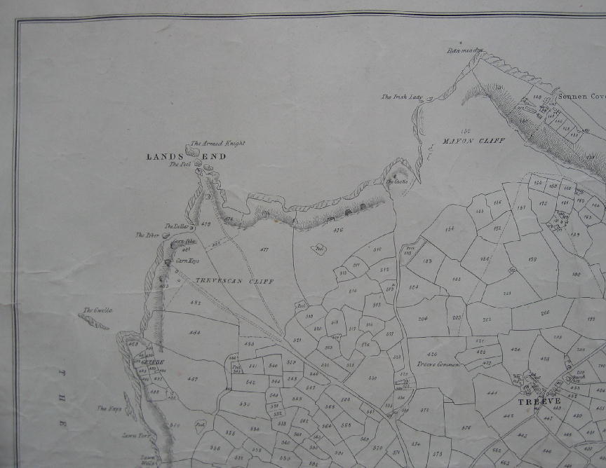
Size 12" x 18" plus margins, loosely inserted in art folder, stiff boards, with ties, arranged geographically from the west with small numbers 1-21 mounted neatly at the tops of the sheets. Pasted inside one board is a printed index map to the sheets. Comprises:- Sheets LXI X.E. & LXVII N.E. (Morvah); LXI S.W. (Zennor); LXVII N.W. (Pendeen Watch); LXVII S.W. (Pendeen); LXXIII N.W. & N.E. (St. Just); LXXIII S.W (Sennen Cove); LXXVIII N.W (Sennen & Land's End); LXXVIII S.W (Gwennap Head); LXXIV N.W (Mounts Bay & Lamorna); LXXIV N.E (Marazion & St. Michael's Mount); LXXVII N.E & S.E (Penberth); LXXIV (N.W (Penzance town); LXXIV Mousehole; LXVIII N.W (Trewey Common); LXVIII S.W (Gulval, Newmill); LXVIII S.E (Ludgvan); LXVIII N.E (Nancledrea); LXI N.E & S.E (St. Ives); LXXIII S.E (St. Buryan); LXXIII N.E (Sancreed); LXVII S.E (Chun Downs). All Second Editions 1908 (Revised 1906), reprints from 1930's and 1940's. Some maps have mines and mine shafts very neatly underlined in red. Loosely inserted in the folder are two large sheets, 1970 reprints of Sheet 33 and 31/32 of the Old Series one inch maps, with extensive cartographical notes by Dr. J.B. Harley. 1930's and later. £185.00


    A further selection of CORNISH Items on Main Site
    Back to the Top

    Devon


  23. County of Devon REGISTER OF LICENCES January, 1903. Records licences in tabular form, borough by borough, with columns for Parish, Population, Acres, Name of House, No. of Licensed Houses, Name and Address of Owner, Occupier, date of last transfer, number of licensed houses within one mile. 76 pages, size 19" x 13", cloth boards, gilt title on front board. Inner hinge partly split. 1903. £80.00

  24. Ordnance Survey THE SECOND PART OF THE GENERAL SURVEY OF ENGLAND & WALES, CONTAINING THE WHOLE OF DEVON, And a Portion of the adjoining Counties. Done by the Surveyors of His Majesty's Ordnance, under the Direction of Lt. Col. Mudge, of The Royal Artillery, F.R.S. A set of maps, with the original title sheet, covering all of Devon, except for Lundy, and including parts of Cornwall, Dorset, Somerset, and South Wales. Scale l" to 1 mile. Copper plate engravings, on 8 sheets, plus title sheet, dissected and mounted on linen, folded over to bind edges. Each sheet has a printed paper label to verso, numbered from 1 to 8 and listing the main towns on each sheet in differing typefaces. Main roads coloured in pale brown. Sheet Nos:- 20, 21, 22, 23, 24, 25, 26, 27. Two sheets have some small areas of foxing in the margins, and small areas of light browning at centre fold, otherwise a clean set, contained in a contemporary box in the form of a book, full calf, gilt lines, leather label, gilt arms of the 'Ordnance' on front of lower portion of box. Some restoration work to edges of calf box, strengthening leather at corners with small inserts of leather, where it was originally bumped, fore-edges of box with new cream paper. All First editions. 1809. £950.00
    The sheets all correspond to Margary state one, having the borders which enable it to be fitted together to form a composite map. Sheet 27 differs from the first edition noted in Margary as it does not have the words 'Meridian of Butterton Hill' before the Longitude in the top margin.


  25. Rock and Co., London VIEWS OF TORQUAY 50 engraved vignette views. Each size approx. 3" x 3«", in boards with gilt title, size 6" x 8«". Cloth on boards very stained and worn, spine spotty and frayed, inner hinge cracked, first view and front endpaper loose. 1860. £70.00
    Despite the state of the binding the plates are very clean.


  26. Turner (J.M.W.) DARTMOUTH Engraved view. From a drawing by Turner, engraved by George Cooke. Size 6" x 9", plus margins, mounted in burgundy card mount, size 14" x 16", with gold line. Description of Dartmouth printed on verso. 1840. £25.00
    Shows a quay in foreground with two small boats loading barrels, the town on the right, mouth of the estuary with castles in the distance.


  27. Werrington and St. Giles ORDNANCE SURVEY MAP Scale 6" to one mile. Size 30" x 18", dissected, linen-backed, folding into 8vo morocco wraps with gilt title. Extends from St. Stephen to Northcott. No margins. c1907. £16.00


    A further selection of DEVON Items on Main Site
    Back to the Top

    Dorset


  28. Netherbury PARTICULARS AND CONDITIONS OF SALE of a Valuable Copyhold Estate in the Parish of Netherbury, which will be Sold by Auction by Mr. F. Pittis, at the White Hart Inn, Beaminster... 24th day of November, 1830. 3pp., small folio, plus docket title, folded. With schedule of the fields, orchards etc. The purchase price, £ 3843.5s.0d, has been added in ink. 1830. £40.00
    The estate was called 'Perry's and Ford's', occupied by John Galpin, with a dwelling house and three cottages.


  29. Stourpaine RELEASE of messuage at France in Stourpaine, George Long to John Parker, Surgeon, of Blandford. Vellum, 18" x 22", armorial wax seal. 1727. £25.00

  30. Wynford Eagle, Puncknowle, Winterbourne Abbas ORDNANCE SURVEY MAP marked with the Duke of Bedford's estates at Swyre and Kingston Russell. Scale 6" to 1 mile, made up of nine quarter sheets joined, linen backed, no borders or marginal information. Size 36" x 54", folded. Two estates extending from Chesil Beach to Swyre and Hamilton Wood, and another around Kingston Russell and Long Bredy shaded in pink, darker pink outline. With note on verso in pencil 'Dorset Estate Dec. 17th 1909.' Folded to 13" x 9". Second Edition 1909. £90.00


    A further selection of DORSET Items on Main Site
    Back to the Top

    Durham


  31. Sunderland PRICE LIST of Colling & Pinkney. Patent Self Reefing & Furling Apparatus. On Her Majesty's Royal Letters Patent. Lithographed on one side of 4to sheet, blue paper. Royal coat of arms, and small illustration of a ship's mast with sail, letters indicating where fittings to be placed. Traces of folds. Small tear in text. c1860. £16.00
    'The Ship to pay for fitting up, also for spars & chains'.


  32. Teesdale & Co. Publisher MAP OF DURHAM Engraved fully hand-coloured map, size 13" x 16". 1832. £40.00
    Shaded in wards.


    A further selection of DURHAM Items on Main Site
    Back to the Top

    Gloucestershire


  33. Bryant MAP OF THE COUNTY OF GLOUCESTERSHIRE being the bottom third only of the complete map. Scale 6 miles = approx 8". Size 24" x 66", plus margins. Fully hand-coloured. Border along bottom and sides, 1" margin at top. Linen-backed, with five vertical folds, along one of which, the fold going through the vignette, the paper has cracked. Scale bar, engraved view of Gloucester Cathedral, Explanation, and five small inset maps showing outlying parts of the County. Published by A. Bryant, 27 Gt. Ormond Street, Nov. 1st 1824. £130.00
    Covers the whole of Bristol, Chepstow, North Nibley, Tetbury, Badminton, Marshfield. The complete map measures 73" x 66".


  34. Gloucester Boundaries REPORT ON THE PROPOSED DIVISION OF THE COUNTY OF GLOUCESTER; 1pp, with a folding plan of the county by R.K. Dawson, coloured in outline. Scale approx. 7 miles to 1". Folio, disbound, some slight offsetting. Shows Polling Places, Places of County Election, Borough Towns to return 1 and 2 Members. 1837. £26.00
    The text shows population in the different towns.


  35. Greenwood (C. & J) MAP OF THE COUNTY OF GLOUCESTER. From an Actual Survey Made in the Year 1823. Corrected to the present Period and Published Jany. 26. 1831. Hand-coloured, size 23" x 28", plus margins, dissected and mounted on linen, edged with silk tape, folding to 8vo, marbled endpapers, small stamp with name of library adjacent to the title, some slight off-setting. With fine large vignette view of Gloucester Cathedral. Greenwood & Co., London: 1831. £70.00

  36. Kitchin (T) A NEW MAP OF GLOCESTERSHIRE Drawn from the best Authorities. Engraved map, size 8" x 10", plus margins. Title with vignette with tress and view of river top right 1774. £25.00


    A further selection of GLOUCESTERSHIRE Items on Main Site
    Back to the Top

    Hampshire and Isle of Wight


  37. Bacon's PLAN OF PORTSMOUTH From the Ordnance & Actual Surveys. Size approx 12«" x 18", single fold at centre. Scale 6" to 1 mile. c1885. £20.00

  38. Lymington, Freshwater ORDNANCE SURVEY MAP Sheet 330. Scale 1" to 1 mile. Size 13" x 19" plus margins, linen-backed. Areas shaded in different colours (in hundreds). Edges dusty. Some amendments made in red ink, for example some place names crossed through and others underlined, some small red crosses around Newport, some names added, for example 'Totland' and 'East Boldre.' Stamp in the top margin 'Bd. of A & F Stock Sheet. If borrowed to be returned to the Survey Branch'. Three stamps of Board of Agriculture in margin. Feint signature bottom right. Railways inserted to 1888. £25.00

  39. Shackleton (Keith) (Painted by) THE SHELL GUIDE TO HAMPSHIRE Poster, lithograph and letterpress printing, glossy surface. Size 29" x 20". Illustration showing waterside view with fisherman, model of a man of war, various birds, butterflies, trout etc. c1960. £35.00


    A further selection of HAMPSHIRE and ISLE OF WIGHT Items on Main Site
    Back to the Top

    Herefordshire


  40. Gentleman (David), Artist SHELL GUIDE TO HEREFORDSHIRE Poster, lithograph and letterpress printing, glossy surface. Illustration showing hop fields, oast houses, corbels from Kilpeck Church, Nell Gwyn, Hereford cattle, etc. Description and map with key below. Overall size 29" x 20", metal hanger top and bottom. Red and yellow Shell logo at bottom. Pin holes at corners. c1960. £32.00

  41. Greenwood (C. & J) MAP OF THE COUNTY OF HEREFORD. From an Actual Survey Made in the Year 1831. Corrected to the Present Period & Published April 1st 1834. Engraved by J. & C. Walker. Hand-coloured, size 23" x 28", plus margins, dissected and mounted on linen, folding to 8vo, marbled endpapers, small stamp with name of library adjacent to the title, few small spots, anda small amount of light browning. With fine large vignette view of Hereford Cathedral. Published by Greenwood & Co. London: 1834. £70.00


    A further selection of HEREFORDSHIRE Items on Main Site
    Back to the Top

    Hertfordshire

    GRAND JUNCTION CANAL

  42. Box Moor A PLAN SHEWING THE COURSE OF THE GRAND JUNCTION CANAL through Box Moor and the Quantity remaining thereof as Common, in the Parish of Hemel Hempstead, Hertfordshire. Lithographed plan hand-coloured, on thick paper backed with linen, scale 4 chains to an inch, size 22" x 29", plus margins. Large decorative title, compass rose. Billingsgate is at the top left corner, Two Waters and the Bell Inn bottom left. Shows Canal, river, buildings in red, gardens with small trees, roads, gravel pit, Back Drain, springs, mile stones, Aqueduct, Great Wharf, Smith' Shop, Lock Houses and gardens, Brewery, area of Common around Canal shaded green. Adjoining owners named. There is a Reference Table bottom left with reference to cottages and gardens giving names of occupiers, and acreages, pieces sold to Canal Company, Quantity Taken for Canal, Towing Path, Lock Houses, Gardens, Back Drain, Bank etc., piece sold to Fourdrinier. Larger buildings such as Duck Hall, Cangles etc., named on map. Many small horizontal creases in surface of paper, two or three where paper has split along crease (only about 1«"). Trace of vertical fold. Lacks all but a small portion of silk edging tape. 1820. £240.00
    Bottom right are the buildings of Fourdrinier's Two Waters Paper Mill (the first mill was downstream at Apsley), one of the first to use machinery in the manufacture of paper. Box Moor Wharf was built at the end of the 18th century with the proceeds of the sale of common land to the Grand Junction Canal Company, the income going to the poor.


    A further selection of HERTFORDSHIRE Items on Main Site
    Back to the Top

    Kent


  43. Snave and Brenzett PARTICULARS AND CONDITIONS OF SALE of Desirable Freehold Property Comprising A Brick and Tiled Dwelling House, Stable... eleven Enclosures of Excellent Pasture Land... For Sale by Auction... 28th day of June, 1904. 2p., folio, plus 1p. conditions of sale, folding coloured plan. Creases, map and pages with repaired tear at old fold, title very dusty at edges. 1904. £20.00

  44. Yalding A MAP OF THE PARCELS OF LAND LAYING IN THE PARISH OF YALDING the Property of Willm. Thorpe, Gentlemen. Manuscript map in colour on vellum, size 23" x 24". Shows plots of land along 'Lattenford Street', with buildings, field boundaries, orchard with small trees, adjoining owners named, ownership of hedges. Reference table top right which is topped by a crude head of a lady. Explanation of the table, and how hedges are indicated, 'E Contains the House Barn Oasthouse and Yards'. Inset bottom right is a small plan 'Map of Four fields of land called (?) the Property of Willm. Thorpe'. This small title and map very faded and indistinct, and browned. Colourful title cartouche top left, crude compass rose, scale bar with dividers, scale at bottom edge very faded, but appears to read 'A Scale adapted to these two maps of 12 Rods to the Inch'. Waterstaining to the bottom left hand corner of the map, not affecting the main map, names of adjoining owners faded. Brown stains just below top border, and on Reference Table. No date. c1750? £140.00
    One of the adjoining owners is 'Lady Austen', of the novelist Jane Austen's family. A Richard Thorpe witnessed the will of John Austen III of Horsmonden. Next to the main property is 'Schoolhouse land'.


    A further selection of KENT Items on Main Site
    Back to the Top

    Lancashire


  45. Accrington INVENTORY of 'Printing Machines, Calenders, Mangles, Winces, Steam Engines... and other machines fixtures articles and things now in and upon certain buildings and premises situate at Broad Oak near Accrington... in the occupation of Frederick Grafton as tenant to Messieurs Hargreaves Brothers and Company. 1856. Signed by Thomas Whittaker and James Parke, Appraisers. 309 pages in manuscript, including Index, in a neat hand throughout, 4to, cloth boards, morocco spine, spine split, front inner hinge broken. Marbled endpapers. Loosely inserted is 'Inventory of Valuation of Machinery, Pipes &c in Bell Shop and Long Shop. 15th April 1867.' 9p, sewn in wraps. 1856 and 1867. £65.00
    Gives detailed description of machines, with measurements, etc. Includes Machine Room, Cooling Room, Gearing, Laboratory, Pattern Cloth Room, Block Print Shop, Bleaching Place, Soaping Place, Worsted Bleaching Place, Boiler House to Madder Dye House, etc.


  46. Colne W.B. WHITE & SONS LTD. Red Scar Works, Colne, Lancashire. Makers of All Kinds of Power Looms, Dobbies, Textile Machinery and Accessories. Established 1849. Catalogue on 51pp., 4to, finely printed on glossy paper, printed wraps. 41 full-page illustrations, plus colour frontis., illustrating looms, winding machines, etc, and 5 pages illustrating small parts. Staples rusty hence two leaves loose at centre. n.d. c1910. £45.00


    A further selection of LANCASHIRE Items on Main Site
    Back to the Top

    Lincolnshire


  47. Gentleman (David), Artist SHELL GUIDE TO THE ROADS OF BRITAIN Sewstern Lane. Poster with picture of the lane south of Grantham. Below is description and small map with illustration of drovers. Size 29" x 20", metal hanger top and bottom. 1950's. £30.00


    A further selection of LINCOLNSHIRE Items on Main Site
    Back to the Top

    London


  48. Cassell, Petter and Galpin, Pub. LONDON (Western Sheet). Sheet from the nine-sheet map originally published by Edward Weller in the Weekly Dispatch newspaper. Lithographed, size 17" x 25", title along top, border on left. Scale 1 mile = 9¬". Traces of central fold. London, Published by Cassell, Petter & Galpin, La Belle Sauvage Yard, Ludgate Hill E.C. 187-. £150.00
    Covers Paddington Workhouse, Lords Cricket Ground, Regents Park Basin, Round Pond in Kensington Gardens. Cassell, Petter & Galpin published between 1858 and 1878, when it became Cassell, Petter, Galpin and Co.


  49. Cassell, Petter and Galpin, Pub. CENTRAL SHEET OF THE NEW EDITION of Cassell's Large Nine Sheet Map of London, Scale, Nine Inches to the Mile. Sheet from the nine-sheet map originally published by Edward Weller in the Weekly Dispatch newspaper. Scale 1 mile = 1¬". Lithographed, size 17" x 25", title as above along top, slight trace of central fold, the word 'London' after 'La Belle Sauvage Yard' has been chipped from the imprint in the bottom margin. London, Published by Cassell, Petter & Galpin, La Belle Sauvage Yard. 187-. £180.00
    Blackfriars bridge is at the centre at the bottom of the plan, The Tower in bottom right corner. Covers Trafalgar Square, St. James Square, British Museum, The Foundling Hospital, St. Pauls', Bunhill Fields, etc.


  50. Princess's Theatre, Oxford Street PLAYBILL Triple playbill for 'Henry The Fifth', March 29th, 1859, advertising 'Farewll Season of Mr Charles Kean'. On thin paper, large sheet folded in three, making 3 pages, each size 10" x 20". Some slight brownish 'shadowing' outlining the letters of the main heading. One page is an address from Mr. Kean, giving his view of the play and his production, and thanking his supporters. 1859. £40.00
    Between Acts 4 and 5 was a special 'Historical Episode' 'taken from the Descriptions given by the Chronicler' presenting Henry V entering London after the battle of Agincourt.


  51. Theatre Royal, Drury Lane DOUBLE PLAYBILL advertising the programme for Feb. 16th, 1857. Size 19" x 19", folded vertically and printed on two pages, variety of decorative type faces. Francis, Printer, Strand. 1857. £45.00
    Programe included 'Black Book' and the Christmas pantomime 'See Saw, Margery Daw: or Harlequin Holiday and the Island of Ups & Downs' (the last word printed upside down), with 130 Ladies of the Corps de Ballet, and the 'Grand Scenic and Mechanical Effects, Exhibiting, in process of Construction The Fairy Factory of Fancy'. One of the scenes was in 'Mappin's Cutlery and Shilling Razor Warehouse' with 'A Pair of Sharp Blades' etc.


  52. Weller (Edw.), Red Lion Square, drawn & engraved by LONDON (South Sheet). Sheet from the nine-sheet map originally published by Edward Weller in the Weekly Dispatch newspaper. Scale 9¬" = 1 mile. Lithographed, size 17" x 25", title and scale bar along top, border along bottom. Traces of central fold, border very slightly clipped along bottom edge for approx. 2". Weekly Dispatch, 139 Fleet Street. (1860's). £180.00
    Shows Westminster Abbey, Houses of Parliament, Millbank Penitentiary, 'Bricklayer's Arms Railway Station', Kennington Oval, etc.


    A further selection of LONDON Items on Main Site
    Back to the Top

    Monmouthshire


  53. Greenwood (C. & H) MAP OF THE COUNTY OF MONMOUTH. From an Actual Survey made in the Years 1829 & 1830. Corrected to the Present Period and Published Jany. 26. 1831. Hand-coloured, size 22" x 28", plus margins, dissected and mounted on linen, edged with silk tape, folding to 8vo, marbled endpapers, small stamp with name of library adjacent to the title, some slight off-setting. With fine large vignette view of Tintern Abbey. Greenwood & Co., 1831. £65.00

  54. Hoyle (Walter), Painter SHELL GUIDE TO MONMOUTHSHIRE Poster, lithograph and letterpress printing, glossy surface. Illustration showing Sugar Loaf Mountain, Skirrid Fawr, Welsh farmhouse, White Castle etc., description and map with key below. Overall size 29" x 20", metal hanger top and bottom. 1950's. £34.00


    A further selection of MONMOUTH Items on Main Site
    Back to the Top

    Norfolk


  55. Aldridge (John), Artist SHELL GUIDE TO NORFOLK Poster, lithograph and letterpress printing, glossy surface. Illustration showing watery landscape, 'flush work' building, Holkham Hall, book of Sir Thomas Browne, various birds, etc. Description and map with key below. Overall size 29" x 20", metal hanger top and bottom. Red and yellow Shell logo at bottom. 2" tear at bottom along metal stretcher. 1950's. £30.00

  56. Forncett St. Peter, Wacton A HIGHLY PRODUCTIVE AND VALUABLE ESTATE FOR SALE the Eleventh of August, 1849. 7pp., folio, folded with docket title, attractive double page hand-coloured plan, with church shown in elevation. Some slight off-setting on plan. 1849. £32.00

  57. Milne (T) A MAP OF THE COUNTY OF NORFOLK reduced from the large Survey in Six Sheets by Thomas Milne Esq. Engraved map, size 24" x 35", parkland, marshland, roads, county boundaries etc., hand-coloured. Dissected and mounted on linen, scale 2 miles = 1 inch. Inserted in original marbled slipcase which is very rubbed, label faded. Two 3" splits at linen at folds, some light dustmarking in sea area top right, 3 small yellowish marks from old sellotape stains in centre of map, small area of rubbing with loss of printed surface just less than half and inch square east of Guestwick, another smaller area of surface loss south of Shipdham. London, Published by the Proprietor W. Faden... Charing Cross 1803. £150.00


    A further selection of NORFOLK Items on Main Site
    Back to the Top

    Northamptonshire


  58. Brigstock, Wadenhoe, Geddington, Corby TWO ORDNANCE SURVEY MAPS Scale 6" to one mile. Each size 36" x 39". Sheet XVIII N.E. and sheets to south and west, and Sheet XVII N.E. and sheets to south and west. Dissected and linen-backed, folding into grey endpapers with Stanford labels, inserted in cloth-covered 8vo slipcase. Second Edition 1901. £38.00
    Covers Lowick to Upper Benefield, Weekly to Middleton. Shows good detail of Boughton House and grounds, Rushton Hall, Glendon Hall etc.


  59. Walgrave, Old & Broughton PARTICULARS AND CONDITIONS OF SALE of Valuable Freehold Estates.... To Be Sold by Auction... 22nd June, 1860. 3pp., plus docket title, folds. Schedule. 1860. £22.00


    A further selection of NORTHAMPTONSHIRE Items on Main Site
    Back to the Top

    Nottinghamshire


  60. Gentleman (David), Artist SHELL GUIDE TO NOTTINGHAMSHIRE Poster, lithograph and letterpress printing, glossy surface. Illustration showing Newstead Abbey, coal mines, bargeware, 'Sons and Lovers', Flawford Madonna etc. Description and map with key below. Overall size 29" x 20", metal hanger top and bottom. Red and yellow Shell logo at bottom. c1960. £35.00

  61. Sherwood Forest ORDNANCE SURVEY MAP Scale 1" to 1 mile. Sheet 113. Size 13" x 19", plus wide margins. Published 1908. £20.00
    Covers Cuckney, Ollerton, Girton. Good black impression.


  62. Walker (J) & (C) NOTTINGHAMSHIRE Folding engraved, hand-coloured map, showing Parliamentary Boundaries, dissected and mounted on linen, engraved area approx. 12«" x 15«", plus margins, folding into 12mo cloth boards, original label. Boards slightly faded, slight browning along two inches at one section edge. 1841. £16.00


    A further selection of NOTTINGHAMSHIRE Items on Main Site
    Back to the Top

    Oxfordshire


  63. Clegg (Ernest), Designed and drawn by OXFORDSHIRE Dedicated by kind permission to Sir A.P. Herbert. Decorative map in bright colours, size 20" x 15", plus margins, on thick paper. Decorative title with view of Oxford and badges of Oxfordshire regiments, views of Ditchley House, Blenheim, etc., around the edge. With extract from Churchill's speech in Washington, Dec. 26, 1941, notes on Penicillin, Radar, Broadwell R.A.F. Station, Churchill at Ditchley, British Farms. On the map are indicated products such as sugar beet, watercress, etc. 1945. £36.00

  64. Hoyle (Walter), Artist SHELL GUIDE TO OXFORDSHIRE Poster, lithograph and letterpress printing, glossy surface. Illustration showing river with Magdalen Tower, dinosaur skeleton, William Morris wallpaper, etc. Description and map with key below. Overall size 29" x 20", metal hanger top and bottom. Red and yellow Shell logo at bottom. 1950's. £30.00

  65. Raine (Rd.) PLAN OF AN ESTATE AT SYDENHAM AND CHINNOR in the County of Oxford, The Property of Henry Burrows Esq., by Richd. Raine 1828. Manuscript plan in ink and wash colour on vellum, size 25" x 22", plus margins. Scale 5" = 6 chains. Title in a variety of decorative lettering styles, with flourishes, compass rose, scale bar. Shows buildings (some in pink some in grey), roads, 'Chinnor Footway', parish boundary, hedges drawn along boundaries of fields and of roads, orchards and gardens, coppice areas. Pasture areas shaded green, arable in buff lines. 'Sydenham Village' marked in bold Gothic lettering, with small drawing of Church in elevation. Adjoining owners named. Reference Table bottom left, with numbers on plan (1-32), with Description of Premises, State, Quantities. Extends from the road from Thame to Chinnor top right, to the road from Tetsworth to the Church on the left. An interesting feature of this map is the many narrow strips of land in 'Sturt Furlong'. 1828. £300.00
    A very finely drawn and lettered plan. Richard Raine (1799-1848) is listed in Eden's Dictionary of Land Surveyors as 'of Doughty St., London and Woodstock, Oxfordshire.' The Burrows family were originally woollen drapers from Thame.


    A further selection of OXFORDSHIRE Items on Main Site
    Back to the Top

    Shropshire


  66. Gotch (Bernard C.), Artist GATEHOUSE, STOKESHAY CASTLE original linocut, black and white. Size 7" x 5", on thin paper mounted along top edge on slightly larger thin card. Signed 'Bernard Gotch' in pencil below border, and titled in capitals. Letter 'G' in bottom corner. 1940's or earlier. £20.00
    Gotch illustrated various books including W.H. Hudson's 'A Shepherd's Life' (1910).


  67. Greenwood (C. & J) MAP OF THE COUNTY OF SALOP. From an Actual Survey Made in the Years 1826 & 1827. Corrected to the Present Period & Published Feby. 24th 1830. Engraved by J. & C. Walker. Hand-coloured, size 23" x 27", plus margins, dissected and mounted on linen, edged with silk tape, folding to 8vo, marbled endpapers, small stamp with name of library adjacent to the title. With fine large vignette view of Shrewsbury. Published by Greenwood & Co. London: 1830. £70.00


    A further selection of SHROPSHIRE Items on Main Site
    Back to the Top

    Somerset


  68. County of Somerset REPORT OF COMMITTEE on the County Prisons, and Places for Holding Assizes & Sessions. 18pp., 4to, sewn at margin. Separately paginated. With tables showing number of Commitments from each Division 1848-1852; Expense of conveying prisoners in Execution and for Trial; Salaries at Somerset County Gaol, Shepton Mallet House of Correction, proposals for the Gaol at Bath etc. 1853. £34.00
    Begins with the names of the Committee members who were appointed to consider the prison accommodation of the County. The Committee recommended having two Gaols in the county, Taunton and one other, to be decided.


  69. Greenwood (C. & I) MAP OF THE COUNTY OF SOMERSET From an Actual Survey Made in the Year 1820 & 21. Corrected to the Present Period and Published July 4th, 1820. Engraved by James & Josiah Neele. Hand-coloured, size 23" x 27«", plus margins, dissected and mounted on linen, edges bound in green silk tape, folding to 8vo, marbled endpapers, small stamp with name of library adjacent to vignette, small amount of light browning. Large fine vignette of Wells Cathedral. C. Greenwood & Co., London: 1820. £75.00

  70. Ilchester A TRUE TERRIER of all such Glybes burgages lands and Tenemts. as belonge to the rectory & Parsonage of Ivelchester... made the 6th day of November 1626... Extracted from the Registry of the Consistorial Episcopal Court of Wells... Manuscript on vellum, size 16" x 8", folds. Lists thirteen tenements, some with adjoining owners. With nine names at the end. Signed as a true copy by E. Parfitt, Deputy Registrar. c1830. £28.00
    For example: 'One Burgage in Bare Close between the lands of John Goff and Ede Masters'.

    PARISH SURVEY

  71. Tucker (J.M), Surveyor SURVEY OF THE PARISH OF WEARE IN SOMERSET 1815 4to, full calf, lacks calf on spine, calf on boards very worn and torn. 55 double-page spreads, with columns for no. on map (not present), Proprietors, Premises, Cultivation, Measure, Value per Acre, Annual Value, Rate, followed by 75 pages giving Proprietors in Alphabetical Order, with premises, cultivation. 1815. £240.00
    807 Proprietors listed.


  72. Wells TO BE SOLD BY AUCTION for the Lives of three healthy Persons; At the Bull's-Head Inn, in the City of Wells... 26th day of January Instant... The Under-Mentioned Messuage Lands and Premises; Situate in the Tithing of Coxley and near to the said City... Handbill, size 15" x 10", some light creasing. Some prices and purchasers' names added in ink. Lists 10 Lots, with name of field, acreages, occupier. Printed by J.E. Lewis, of whom may be had Stamps for Bills.... 9th January 1815. £45.00
    Includes land called South Croft at Polsham, Folly-Ground, Dwelling House at Coxley.


    A further selection of SOMERSET Items on Main Site
    Back to the Top

    Staffordshire


  73. Greenwood (C. & J) MAP OF THE COUNTY OF STAFFORD. From an Actual Survey Made in the Years 1818 & 1819. Corrected to the Present Period & Published Feby. 24th 1830. Josiah Neele, sc. Hand-coloured, size 23" x 28", plus margins, dissected and mounted on linen, edged with silk tape, folding to 8vo, marbled endpapers, small stamp with name of library to lower corner. With fine large vignette view of Lichfield Cathedral. Published by Greenwood & Co. London: 1830. £70.00

  74. Hollington PARTICULARS of Very Valuable Freehold Stone Quarries, Building Land, Substantial Stone Cottages at Hollington, Public-House, Blacksmith's Shop, Cottages and Garden at Beamhurst... to be Sold By Auction... 9th May 1857... 1p., folio, with details in a variety of large decorative type-faces at top, and list of the 13 Lots in the bottom half, plus conjoint leaf with docket title, and a full-page hand-coloured plan. Docket title very dusty. 1857. £28.00


    A further selection of STAFFORDSHIRE Items on Main Site
    Back to the Top

    Wiltshire


  75. Sun Fire-Office FIRE INSURANCE CERTIFICATE for the insurance against loss or damage by fire of John Payne's Property at Melksham, Wiltshire, which consisted of 'a Dwelling House and Cheese Chamber communicating called Bowerhill near Melksham in tenure of Uriah Glass - all Thatch'd'. Printed certificate, 1791, with manuscript inserts, on thick paper, size 19" x 12", horizontal folds. Finely printed, with bold copper engraving, size 4" x 5«", Clark, Sculpt. Moorfields, showing a fireman with axe, and another man carrying a sack of good, in front of a building, illustration of fire engine, large sun with a face, tools etc. Impressed stamps, signed by three Trustees with small impressed stamps of the Company. On the verso is a memorandum, on the death of John, signed with wax seals by the sons, assigning the policy to Richard Payne... together with... PROPOSALS From the Sun-Fire-Office in Cornhill, May 3rd, 1787. Folio sheet printed on both sides in double columns, with large sun at the top, name of Payne and number of policy written at the top in ink. S. Clarke, Broken-Row, Moorfields. 1787-92. £60.00
    John Payne is described as a Goldsmith, as are his sons.


  76. Wheatley (William Walter) MANOR HOUSE, YATTON KEYNALL Watercolour, initialled, of the house looking across the path in front, figures by the gate, woman in the doorway and another at first floor window, view across fields on right, trees on both sides. Initialled. Size 11" x 15", painting completely filling paper, in buff mount, overall size 17" x 23". c1860. £200.00
    William Walter Wheatley (c1811-1885) was a prolific painter of antiquities, churches, and old buildings in Wiltshire and Somerset. He worked for various patrons including George Weare Braikenridge. Born in Bath, he lived for a time in Rode.


  77. Wheatley (William Walter) LONGBRIDGE DEVERILL as it was about 1845. Church, Bridge, etc., all altered. Property of Marquis of Bath. Watercolour, size 11«" x 15«", in buff mount, size of mount 18" x 23". Lettered neatly on back of mount as above. Initialled 'WWW' bottom right. c1860. £220.00
    A very attractive scene showing people on wooden bridge, two attractive thatched cottages in foreground, one with washing hung out, other cottages surrounding church, many figures. Trees in background. Wheatley (c1811-1885) was employed over a period of ten years by Francis Weare Braikenridge, the Bristol antiquarian, to record old houses, churches, monuments, etc., in Somerset. It was hoped they might be used to illustrate a new edition of Collinson's Somerset. He was born in Bath, and lived for a time at Rode in Somerset.


    A further selection of WILTSHIRE Items on Main Site
    Back to the Top

    Worcestershire


  78. Abberton HISTORICAL FREEHOLD ESTATE to be Sold in 44 Lots on Thursday, September 7th, 1905 at the Grand Hotel, Birmingham. The Abberton Estate, Worcestershire, comprising the Entire Parish of Abberton, and a large Part of the Parishes of Flyford Flavel, Naunton Beauchamp, Bishampton, North Piddle, Kington, Dormston and Grafton, containing about 2,408 Acres... the Manorial and Residential Estate of Abberton with Country Mansion, Part of Village... The Manor Farm, Abberton Mill, Baynhall Farm, The Court Farm with the Advowsons of Kington and Dormston... 40pp., size 18" x 11", original wraps with photo, some scuffing of surface of paper on part of front wrap, foxing and some dust-staining on front wrap. 15 very large coloured folding plans, key map on back wrap. 23 photographs in text, many with groups of people, cart horses, pony carts etc. Some damp sports on top half of title page, and two spots on first page with Summary of Lots. 1905. £95.00
    With interesting historical notes on the Manor and Hall.


  79. Alcester and Redditch AUCTION SALE PARTICULARS Ludlow & Briscoe will Sell... on Thursday June 20th, 1907, at 4 p.m., The Worcestershire Estates of the Late Miss Phillips... Divided into 39 Lots.... The Cook Hill Priory Estate... The Nunnery Wood Property, An Attractive Freehold Sporting Estate Adjoining and Woodland Cottage... Cook Hill Farm... Gannow Farm, Rush Farm, Inkberrow... Tookey's Farm, Astwood Bank... 24pp., size 18" x 11«", wraps printed in red and black with photo, recent new cloth spine. With 5 very large folding coloured plans, and two single page plans. Key map on back wrap. 7 photographs in text. 1907. £80.00
    'Cook Hill Priory... comprises the quaint brick and stone and half-timbered Homestead, constructed on the site of, and partly from the materials of, the old Priory, together with a brick and stone-faced wing erected about the reign of George II, and a very old and interesting Chapel adjoining...' The estate was granted to Nicolas Fortescue on the dissolution of the monasteries.


  80. Greenwood (C. & I) MAP OF THE COUNTY OF WORCESTER. From an Actual Survey Made in the Years 1820 & 1821. Corrected to the Present Period & Published Feby. 24. 1830. Engraved by J. & C. Walker. Hand-coloured, size 23" x 28", plus margins, dissected and mounted on linen, edged with silk tape, folding to 8vo, marbled endpapers, small stamp with name of library adjacent to the title. With fine large vignette view of Worcester Cathedral. Published by Greenwood & Co. London: 1830. £70.00


    A further selection of WORCESTERSHIRE Items on Main Site
    Back to the Top

    Yorkshire


  81. Badmin (S.R), Artist SHELL GUIDE TO YORKSHIRE Poster, lithograph and letterpress printing, glossy surface. Very attractive illustration showing Scarborough castle, Bolton Abbey, high tea with parkin etc., Wuthering Heights, Whitby in distance, etc. Description and map with key below. Overall size 29" x 20", metal hanger top and bottom. c1960. £36.00

  82. Castleford PLAN AND PARTICULARS of Valuable Building Sites at Castleford, to be Sold by Auction... 16th January, 1873. 2pp., folio, folded with docket title. 1873. £30.00
    Comprised 29 plots of land north of Albion Street. The streets are marked as 'Intended'.


  83. Hull SECOND REPORT of the Committee Appointed to Obtain Additional Dock Room at the Port of Hull. 3pp., folio, folded with docket title. Ross, Printer, Bowlalley-Lane, Hull. 24th February, 1820. £30.00
    'The Port of Hull unquestionably possesses local advantages superior to most other sea-ports in the United Kingdom, and it is painful to reflect, that, by the disjointed situation of the docks, these advantages are in a great measure rendered inefficient...'


    A further selection of YORKSHIRE Items on Main Site
    Back to the Top

    Scotland


  84. Grant (Keith), Artist SHELL GUIDE TO SHETLAND Poster, lithograph and letterpress printing, glossy surface. Illustration showing rocky bays, stacks, Brock of Mousa and Jarlshof, wheelhouse, pullover, Viking comb, school of dolphins, etc. Description and map with key below. Overall size 29" x 20", metal hanger top and bottom. Red and yellow Shell logo at bottom. c1960. £38.00

  85. Hogg (Alexr.) A GENERAL VIEW of the City & Castle of Edinburgh, the Capital of Scotland. Copper engraving, size 8" x 11", plus margins, decorative border. Shows view looking across the city towards Fife, figures in the foreground. Paper slightly darkened at edges, with some creases and edge tears in side margins... together with a similar engraving with two views, Montrose and Channery, which is slightly creased. Two items. 1784. £15.00
    Both engravings are from Hogg's 'The New British Traveller'.


  86. Rosoman (Keith), Artist SHELL GUIDE TO INVERNESS-SHIRE Poster, lithograph and letterpress printing, glossy surface. Illustration showing Braeriach in the Cairngorms, cairn from Culloden Moor, Flora Macdonald, capercaillie and black grouse, salmon flies, cairngorm brooches, bagpipes, etc. Description and map with key below. Overall size 29" x 20", metal hanger top and bottom. Red and yellow Shell logo at bottom. c1960. £35.00


    A further selection of SCOTTISH Items on Main Site
    Back to the Top

    Wales


  87. Greenwood (C. & J) MAP OF THE NORTH WEST CIRCUIT OF THE PRINCIPALITY OF WALES, COMPRISING THE COUNTIES OF ANGLESEY, CAERNARFON & MERIONETH. From an Actual Survey Made in the Years 1830 & 1831. Corrected to the Present Period & Published April 1st 1834. Engraved by J. & C. Walker. Hand-coloured, size 23" x 27", plus margins, dissected and mounted on linen, folding to 8vo, marbled endpapers, small stamp with name of library to lower corner. With fine large vignette view of Bangor Cathedral. Published by Greenwood & Co. London: 1834. £70.00

  88. Greenwood (C. & J) MAP OF THE SOUTH WEST CIRCUIT OF THE PRINCIPALITY OF WALES, COMPRISING THE COUNTIES OF CARDIGAN, PEMBROKE AND CAERMARTHEN. From an Actual Survey Made in the Years 1832 & 1833. Corrected to the Present Period & Published April 1st 1834. Engraved by J. & C. Walker. Hand-coloured, size 24" x 30«", plus margins, dissected and mounted on linen, folding to 8vo, marbled endpapers, endpapers slightly rubbed to lower corners. With fine large vignette view of St. David's Cathedral. Published by Greenwood & Co. London: 1834. £70.00

  89. Greenwood (C. & J) MAP OF THE SOUTH EAST CIRCUIT OF THE PRINCIPALITY OF WALES, COMPRISING THE COUNTIES OF GLAMORGAN, BRECON AND RADNOR. From an Actual Survey Made in the Years 1826 & 1827. Corrected to the Present Period & Published January, 26. 1831. Engraved by Josiah Neele. Hand-coloured, size 24" x 27«", plus margins, dissected and mounted on linen, folding to 8vo, edged with silk tape, marbled endpapers, small stamp with name of library adjacent to the title. With fine large vignette view of Llandaff Cathedral. Published by Greenwood & Co. London: 1831. £70.00


    A further selection of WELSH Items on Main Site
    Back to the Top

    General


  90. Devon and Cornwall SET OF FOURTEEN ORDNANCE SURVEY MAPS Scale 1" to 1 mile. Sheet 28 (Lundy), Sheet 29 (Hartland), Sheet 30 (Bodmin), Sheet 32 (Lizard), Sheet 33 (Penzance), Sheet 34 (Truro) and in a separate box Sheet 20 (Bridgwater Bay), Sheet 21 (Honiton/Taunton), Sheet 22 (Exeter, Teignmouth), Sheet 23 (Dartmouth), Sheet 24 (Plymouth), Sheet 25 (Tavistock), Sheet 26 (Bideford, Okehampton), Sheet 27 (Ilfracombe). Dissected and linen-backed, folding to 13" x 9", silk edging tape, small key maps on front, red star. Main roads coloured buff. Borders pasted on. A few small foxing spots on Lundy sheet. Inserted in glossy folded card with red star with Gardner imprint, in two fine heavy dark blue morocco slip-cases, with lift off tops, gilt lines, gilt title, gold sides. Published 5th Jan. 1813, by Lt. Col. Mudge, Tower. Later, c1820. £1,200.00
    Margary state 3. With the scarce Lundy sheet.

    PROVOSTSHIP OF ETON

  91. Eton College LETTER from Dr. William Barford to Edward Wynne Esq. Dated Canterbury Nov. 6. 1781. 39 lines on two sides 4to, conjoint leaf with address on verso, addressed to Edward Wynne Esq. at Paper Buildings, Temple, London, Canterbury postmark, wax seal torn away leaving hole in paper below address. Docketted on verso 'Dr. Barford about the Provost-ship of Eton on Dr. Barnard's death. 6 Decr. 1781 tho' dated Nov 6'... together with... TWO LETTERS addressed to Edward Wynne at Essex Street, The Strand, London, from J. Brooke at Eton, with a poem by Wynne, the three folded together and docketted by Wynne 'Brooke and my answer in verse. 1752'. Both letters with address panels, broken wax seals, postmarks. The first, Dec. 14, 1751 describes a play, presumably put on at the school 'I suppose this will find you in the midst of your Jollity which we now begin to have a Scent of: we have finished our Play... the Subject Matter is the Story of Elijah...' he describes the plot, which involved '50 young prophets'. 2p., small 4to. The other letter, dated Eton March 29 1752 is a jocular poem of 58 lines, with a few lines in Latin, describing him wandering lonely around Eton, being forced to stay for the holidays 'While Thame's meanders mournfull roll/On the deserted banks I stroll... I Mother Eton's gloomy state/In sad contentment contemplate...' His 'Dame' had brought him a letter from a family called Cornwallis who could not receive him for the holidays. He ends 'Dame's Compliments - and now I'll end/So, hoping that you mind your Book/Believe me yrs. sincerely Brooke/ P.S. I have no Frank, tis very true/Or else I'd Frankly send it you'. Wynne's reply is a poem of 18 lines, 2p., sm. 4to, based on Horace 'I sigh not to be made a Bishop/Nor heed what wind may bring the fish up'... together with... 'On the resignation of the Revd. Dr. Lloyd M.A. late second master of Westminster School, The King's Schollars presented him with a piece of Plate... ' with the Latin verse in 14 lines extolling Lloyd (Qui in Scola Westmonasteriensi/circiter annos 47... etc.' 1 page, sm. 4to in a rather childish hand. 5 items. 1751-1781. £175.00
    Barford thanks Wynne for his kind letter and for 'the creditable light in which you place me', but says he does not feel equal to 'the great office in question', and as he is now growing older 'I am desirous of living for the discharge of parochial duties, for the few Friends who esteem me, and for myself: to these offices I am still commensurate, and it would be criminal in me to disquality myself from executing what is in my power by possessing a place of which I feel myself unworthy...'. Educated at Eton and Kings College Cambridge, Barford became a tutor at King's and then for a short while chaplain to the House of Commons. He was then made a prebendary of Canterbury. Wynne was writer of legal works. At the time of the letter from Brooke he would have been only 17.


  92. Gloucestershire and Wiltshire GEOLOGICAL SURVEY SHEET Sheet XXXIV. Scale 1" to 1 mile. Hand-coloured map. Size 27" x 33", coloured key in margin. Railways inserted to 1890. Blindstamp of Board of Agriculture, 1893. £75.00
    Covers Minchinhampton, Tetbury, Chippenham, Cirencester, Swindon.


  93. Kitchenware TRIPLEX '22' Cooker. Brochure with details of Aga-type cooker, 4to, 6pp., three illustrations of the different models, one in green. Elegant wraps showing green cooker on black background. c1935. £12.00
    The Triplex Foundry was in Great Bridge, Staffordshire.


  94. London & South Western Railway BOOK OF REFERENCE Amesbury and Military Camp Light Railway. 1897. 11pp., printed on one side only, folio, printed wraps, cloth spine. Tables with columns for Property, Owners, Lessee, Occupiers. Cloth spine damaged so front wrap loose. 1897. £32.00

  95. (Moll, H) A NEW MAP OF THE RIVERS And Sea Coasts of England. Engraved map, size 11" x 11", central horizontal fold. Title and scale bar top right. Shows the Counties and Rivers (which are named), ports along the coasts, main towns. 1720. £60.00

    COASTAL DEFENCES

  96. Palmerston Forts SET OF MAPS TO ACCOMPANY THE REPORT OF THE ROYAL COMMISSION on National Defence. 1860. Set of nine maps, scale 1" to 1 mile, in a plain cloth-covered slip-case, size 13" x 7". All maps except (ii) are from the Ordnance Survey, Zincographed at the Ordnance Survey Office Southampton, under the directionof Capt. A de C. Scott, R.E., linen-backed but not dissected, folding into marbled endpapers. Water features hand-coloured, each map marked with red and green circles in watercolour, to denote 'Sites for Works recommended by Royal Commission', and 'Existing Sites' respectively. Maps comprise: (i) THAMES, MEDWAY, SHEERNESS AND CHATHAM. Size 14" x 20" plus margins. Areas outlined in light blue marked 'Can be inundated'. Shows a ring of forts from Gadshill to Lorne Battery, linked with a dotted red line, others at Isle of Grain, Furze Hill, Oakham Ness etc. (ii) SPITHEAD, NEEDLES AND THE ISLE OF WIGHT. Surveyed by Captn. Sheringham R.N. 1851. Malby & Sons, Lithographers. Size 24" x 36". Sea shaded in duck egg blue, land in buff. Many soundings, symbols to show gravel, clay, shell, information about tides, heights above high water on land, and depth of water at high water. Forts coloured red and green as above. Shows line of forts along Portsdown, Black House, Roome, Bembridge, etc. many fortifications in clusters such as between Alum Bay and Hurst Castle, many red lines joining the smaller red circles, line of existing forts coloured green from Fort Monkton to Elson Fort, etc. (iii) WOOLWICH. Size 10" x 12" plus margins. Shows one 'site of works recommended' near Shooters Hill, yellow dot at East Ham and yellow lines to show projects alluded to in the Report. (iv) PLYMOUTH. Size 11" x 11" plus margins. Shows line of forts in red from St. Stephens round to Staddon, and other places, existing works at Tregantle, etc., 'Red lines shew the course of Ships entering the Harbour'. Soundings in feet shown. (v) DOVER. Size 11" x 6" plus margins. (vi) PORTLAND. Size 11" x 7«". Works existing and in progress only shown. (vii) PEMBROKE DOCKYARD AND MILFORD HAVEN. Size 11" x 25" plus margins. Recommended chain of works around Pembroke Dock, works at Tenby, Caldy Island, Gravel Bay etc. (viii) CORK HARBOUR AND HAULBOWLINE. Size 10" x 8" plus margins. Scale 3 miles to an inch. (ix) MAP OF THE SOUTH OF ENGLAND. Shewing the spaces enclosed by the Works of Fortification recommended by the Royal Commission. February 1860. Scale 10 Miles to an Inch. Size 18" x 36". Areas blocked in red corresponding to the 6 area maps, Ireland (Cork) not shown. 1860. £340.00
    The government was concerned about the threat of invasion from France under Napoleon III and a Commission was instructed in 1859 to 'examine the plans of the works now in progress at Portsmouth (including the Isle of Wight & Spithead), Plymouth, Portland, Pembroke, Dover, Chatham & Medway' and to consider making the dockyards defensible in as short a time as possible. The text of the actual Report is not present.


  97. Peachey (James) LETTER dated St. James Street, April 15, 1752. To 'Mr Timy. Waldo'. 1p., 4to, blank conjoint leaf with 'For Mr. Timothy Waldo'. 26 lines in a neat hand, setting out details of financial transactions between them. 'I left with yr clerk Last week the mastr. in chancerys Report of what was due To Each Person in the Bill mentioned... due to me at midsumr. 1747 the sum of £ 5333 7s from which deducting the Purchase money clear of cost of Suit £ 3811 15s...' Tipped onto album leaf down left side. 1752. £30.00
    The Waldo family owned Hever Castle in Kent. Timothy Waldo is described in 'British History Online' as 'an eminent merchant of London'


  98. Somerset and Dorset A SURVEY AND VALUATION of the Farms, Lands and Tenements belonging to Mrs. Clarissa Vigor in the Parishes of Mark, Winford and Kinston-Seymour in the County of Somerset and in the Parishes of Buckland-Ripers and Broadway in the County of Dorset. Done in 1788, 1789 and 1790 by Richard Richardson of the Devizes. Manuscript, very neatly written. Title page in bold lettering with a variety of calligraphic styles, one page 'General Summary', and 12 double-page spreads ruled in columns for Premises, State in 1789, Quantity, Per Acre, Annual Value, Remarks, written on rectos only. 4to, size 10" x 8", marbled boards, calf spine. The name of the tenant is added in pencil top right. 1790. £95.00

  99. Stanford's Geographical Establishment MAP OF ENGLAND AND WALES Showing the Areas of the Principal Electrical Power Companies. Specially Prepared for Geo. D. Atkin & Co. Reproduced from the Ordnance Survey Map. Colour-printed map, size 34" x 42", dissected and mounted on linen. Scale 10 miles to the inch. Folding into green cloth boards, size 11" x 7", paper label on front board. May 1929. £55.00
    With key to colour shading for 15 Electrical Companies and coloured borders for 11 Schemes.


  100. Venerable Bede BEDE'S ECCLESIASTICAL HISTORY Translated from the Anglo Saxon Version of King Aelfred. Manuscript transcription on 535 pages, in volume size 12" x 9". Written in a clear bold hand, approx. 20 lines per page. Fore-edges and bottom edges of paper uncut. Half calf, marbled boards, gilt title on spine. Calf split at hinges. Calf rubbed at edges. With armorial bookplate of The Revd. Jarvis Kenrick, Blechingly. Paper watermarked 1828. A later owner (possibly Kenrick) has corrected a mistake in the page numbering, and put in headings in the top right margins e.g. 'Augustine's death', and notes on title 'This omits the text of several letters and also chapters bearing on Scottish history...' c1830. £110.00
    Jarvis Kenrick was a Vicar in Chichester, and later Rector of Caterham. His son, also Jarvis Kenrick, was a footballer who scored the first ever goal in the F.A. Cup, in 1871.


A further selection of BRITISH TOPOGRAPHY & LOCAL HISTORY Items on Main Site
Back to the Top
TO ORDER or for further information contact Lesley Aitchison :-
Tel:- ( 0117 ) 9076899
Email :- lesley@localhistory.co.uk
Go to LESLEY AITCHISON'S Home page
NOTE:
This is an old catalogue and many of these items are probably sold.
Please contact as I may have similar items in stock.
This page shows the range of items I specialise in BUYING and SELLING.
Copyright © Lesley Aitchison - 2014. All rights reserved.